All Activity
- Past hour
-
Yea. If one does happen, I can’t see it being on the same level as February, 2018. That SSWE was just off charts, very highly anomalous. I’d have to say the chances of seeing two in less than a decade is extremely unlikely, but I guess stranger things have happened
-
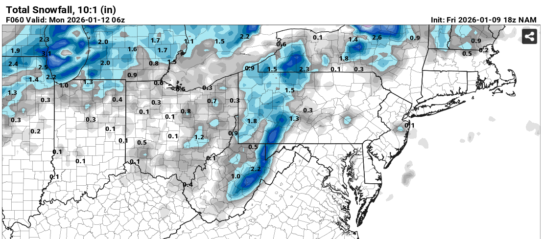
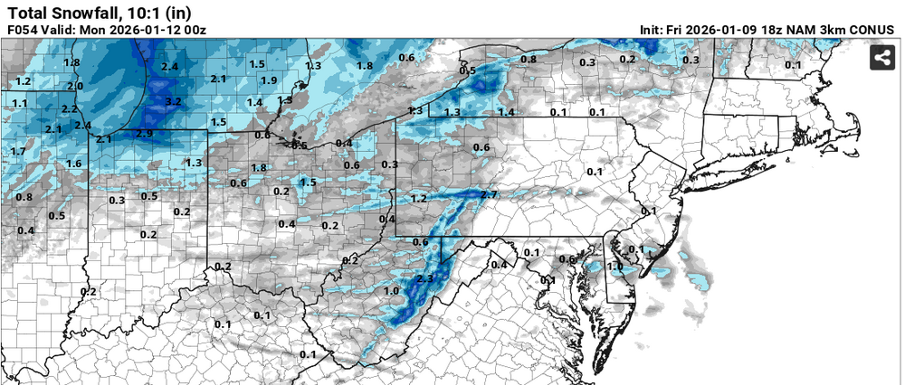
Continuing what it was showing earlier, the NAM Nest still likes Sunday afternoon for some of us getting a burst of convective snow. The CAPE field is non-zero, and other mesoscale models hint at the same idea:

-

Pittsburgh/Western PA WINTER ‘25/‘26
colonel717 replied to Burghblizz's topic in Upstate New York/Pennsylvania
As we know these little events are the bread and butter of our winters. Hopefully we can pull an inch or 2.
-
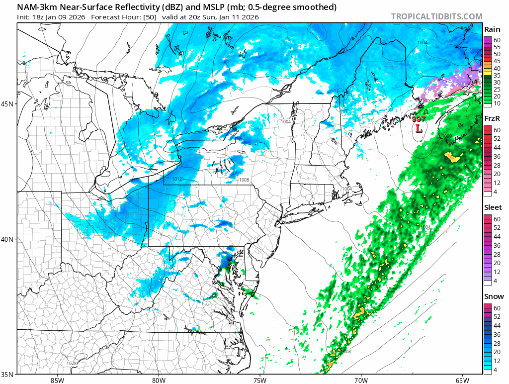
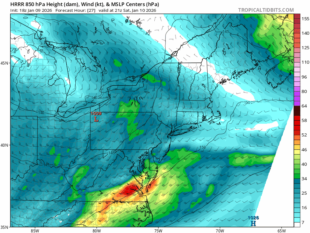
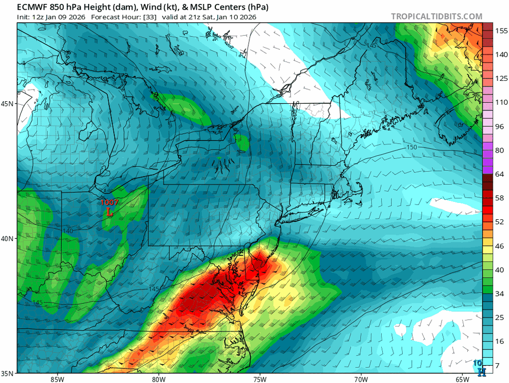
FWIW, the HRRR has a much weaker and more veered 850 mb wind field than most of the other guidance. The images below show a massive difference in the intensity of the overrunning.
-

Occasional Thoughts on Climate Change
TheClimateChanger replied to donsutherland1's topic in Climate Change
So I've been working on a new concept I call "climate analog pairs" and basically it looks to pair a location's current climate with a late 20th century climate of another location hundreds of miles south. I actually think it's more intuitive going in the opposite direction. As a millennial, you may want to determine where you can locate the climate of your childhood. Unfortunately, it's no longer going to be in your hometown but rather hundreds of miles north of your hometown. I think this is a better way of looking at climate change - rather than saying its warmed a couple of degrees, one could say instead it's warmed so much that the local climate has been replaced with the late 20th century climate conditions 200 miles south of here. Here's the thread where I explain the concept and then address a couple of anticipated objections. Any thoughts? -

Winter 2025-26 Short Range Discussion
A-L-E-K replied to SchaumburgStormer's topic in Lakes/Ohio Valley
this is our moment -
nice, was thinking that we ended up right around 2"
-
I wouldn’t be shocked if we trend firmly towards the first event not delivering soon and the models really hone in on system 2. There’s definitely a path for storm 1, but my thinking: Current mess outside - initiates the changes we need late weekend. Pattern becomes more favorable. Storm 1 - lays out the plates, fine china and silverware. Establishes cold profiles and makes way for storm 2. Storm 2 - Delivery
-
Powell, I hate to hear that. Hang in there.
-
JB, Steve D , DT and Henry Marquisity also.
-

2025-2026 ENSO
so_whats_happening replied to 40/70 Benchmark's topic in Weather Forecasting and Discussion
I am honestly on the fence with it. Typically we only see a full destruction of the SPV 1-2 times a decade. I have a feeling we may have to wait but hope I am wrong. -

E PA/NJ/DE Winter 2025-26 Obs/Discussion
Birds~69 replied to LVblizzard's topic in Philadelphia Region
Incoming rain junk heading in. Dark-gloomy-ominous looking clouds outside... 50F/Going to be a raw night/Sat -

January 2026 regional war/obs/disco thread
brooklynwx99 replied to Baroclinic Zone's topic in New England
you're right. just kinda hard to take sometimes when someone's insulting your intelligence in that way. i worked my ass off for this lmao -
The Euro Weeklies this afternoon definitely support that CFS MJO map. Get a good window from say Jan15-22nd-ish. Then, we roll a ridge complex through to end the month, then do it again to start February. The interesting thing will be if the cold can actually retreat or if it gets trapped under a HL block. The Euro control had the EC cold throughout the run. Just kind of seems like it is going to be difficult to push the cold out of the pattern for long periods of time, but I could be wrong! Ripe, ripe, ripe for an ice storm if we push a 500 ridge into the SE but the surface doesn't respond to the AN heights, ie stays cold.
-

January 2026 regional war/obs/disco thread
CoastalWx replied to Baroclinic Zone's topic in New England
You don’t have to engage. We all seen your posts and your reasoning and the quality of your posts. It should just roll off your back. -
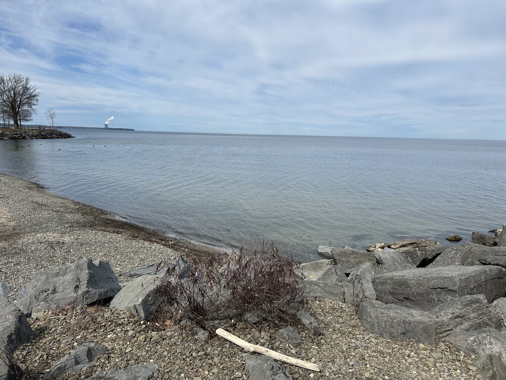
I took the photo below in April 2024. This from a park in upstate NY called Mexico Point State Park. It’s on the shore of Lake Ontario right in the heart of the snow belt country. It looks and feels like the shore of LI Sound. A town called Pulaski just a few miles away recorded 4 feet of snow in two days with a lake effect event in the past two weeks. If you want to see KU style snow events each year this is where you need to be.
-
I don't want to "attack" anybody. I'm going to stop responding to specific posts that are personal in nature. I've made my point. Wishing deep snow for everybody.
-

January 2026 regional war/obs/disco thread
Damage In Tolland replied to Baroclinic Zone's topic in New England
That depends. Did you vote for DJT? -
January 2026 regional war/obs/disco thread
CoastalWx replied to Baroclinic Zone's topic in New England
Posting something showing a trend or what not is not a forecast. You have no idea what he forecastsor what his record is. So it’s kind of shitty for you to attack his expertise. It’s a Weather forum. This forum really shouldn’t be used as a grade of people’s forecasting skills, unless they put their balls out there. If you want to grade people on how they talk about the pattern, feel free to go ahead and personally I think he knows his stuff because when I see his posts describing the pattern, I don’t necessarily disagree with his reasoning. So don’t be a dick and attack someone who is a degreed met. This field already has enough dicks in it. -
I disagree. Prove me wrong. I've been posting on this board for a very long time. I've never read a solid forecast from you. Maybe you only provide them privately. You post the same thing on several sub forums. It's pretty much always the same thing.
-
January 2026 regional war/obs/disco thread
brooklynwx99 replied to Baroclinic Zone's topic in New England
i literally won most forecasting competitions in my classes at school and had a negative Z-score in WxChallenge. just stop it -
Pittsburgh/Western PA WINTER ‘25/‘26
TheClimateChanger replied to Burghblizz's topic in Upstate New York/Pennsylvania
Really can't beat this, with temperatures nearing 70F in southeast Ohio. -

Richmond Metro/Hampton Roads Area Discussion
chris624wx replied to RIC Airport's topic in Mid Atlantic
12Z GFS is a beaut for NE NC/SE VA late next week! -
Encouraging 3-4 week outlook. https://www.cpc.ncep.noaa.gov/products/predictions/WK34/
-
I think one of the big issues with storm 1 is its coming down too far east and doesn't have time to dig enough to our west and amplify. If we can move the trough slightly west and continue the trend of having a taller western ridge we could still score from that one.