All Activity
- Past hour
-
 Next winter you will be begging for mercy.
 -
 C'mon man...just enjoy the little stuff too. Winter really got to ya, didn't it? (Now with the missed blizzard I definitely understand the Eeyoring for that, lol Took me a day and a half to shake the bad mood from that one!)
 -
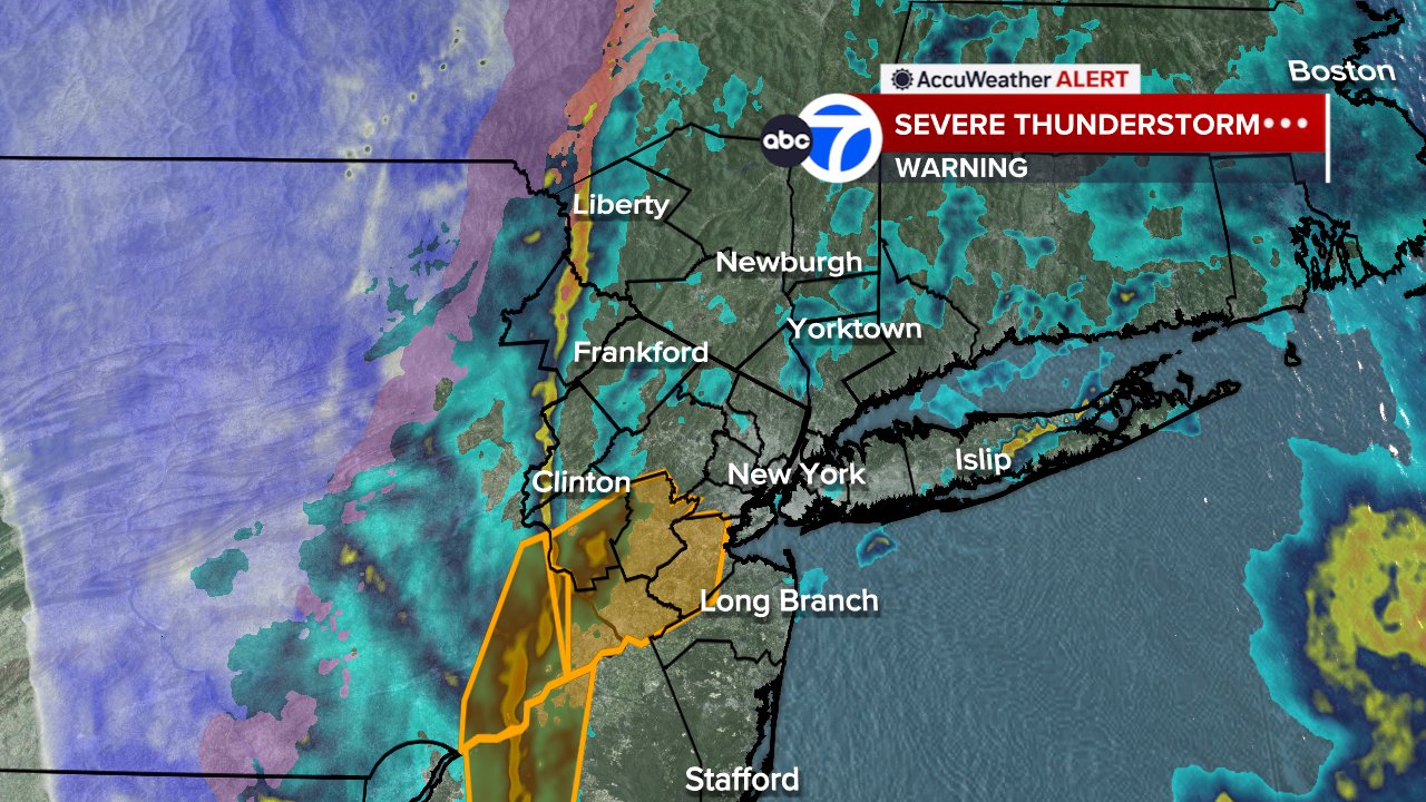
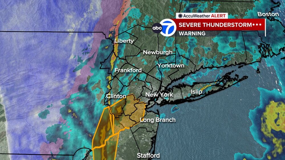
Squall line approaching. Severe warned over western nj
-
Cool radar shot from Channel 7
-
(002).thumb.png.6e3d9d46bca5fe41aab7a74871dd8af8.png)
E PA/NJ/DE Spring 2026 Obs/Discussion
ChescoWx replied to PhiEaglesfan712's topic in Philadelphia Region
Plenty of downed trees in the area - we had the power go out 5 times with the generator on and off. Temp down to 39.3 and the rain has changed to snow just to my west in NE Lancaster County -
I thought it was supposed to rain and be windy?
-
2.09 going to really put stress on already high rivers here and not all snow had melted
-

Central PA Spring 2026 Discussion/Obs Thread
Mount Joy Snowman replied to Voyager's topic in Upstate New York/Pennsylvania
Had a period of steady sleet with a temp of 37 and now it appears I’m transitioning to snow as the temp has dropped to 35. Glorious. I need to go to bed but…..snow. -

E PA/NJ/DE Spring 2026 Obs/Discussion
enpawx_observer replied to PhiEaglesfan712's topic in Philadelphia Region
42 here, down 18 in the past 20 or so minutes. My PWS which is not in an optimal position for northerly wind reported a 28mph gust, but the guy up the street who has one in a better position reported a 58.2mph gust on wunderground. -
Quite the CAD in the lee of the Whites. 41˚ at KMWN, warmer than anything in basically an Ossipee-Bridgton-Crawfords triangle. Although anyone over about 1000' AMSL is warmer. Meanwhile KHIE is 58˚.
-
Pingers here...can't remember the last time we had two T-storm to frozen events in one winter, lol
-

Pittsburgh/Western PA WINTER ‘25/‘26
TimB replied to Burghblizz's topic in Upstate New York/Pennsylvania
Lucking into a semi-respectable March snow total from one overperforming event in what has otherwise been a torchy, April-like month is really something. That puts the official seasonal total over 50”. -
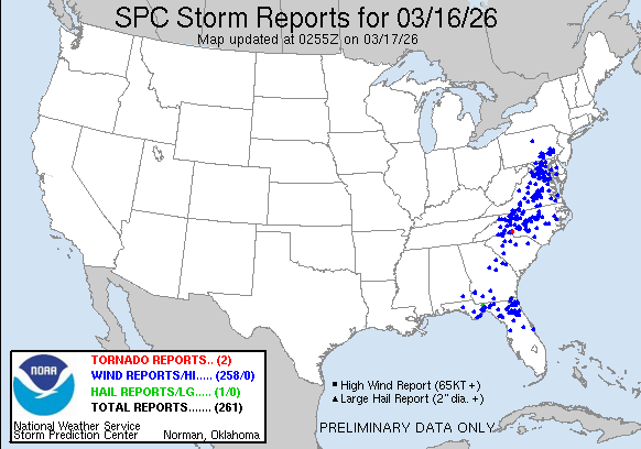
Here’s a tally as of 10:55PM EDT today: only 2 tornadoes and 1 large hail event! But there still were 258 high wind reports! So, it wasn’t exactly quiet:
-

E PA/NJ/DE Spring 2026 Obs/Discussion
Birds~69 replied to PhiEaglesfan712's topic in Philadelphia Region
Electrical fires seem to be the hot ticket... Fire Incidents Incident No. Incident Type Incident Location Municipality Dispatch Time Station F2608362 ELECTRICAL FIRE OUTSIDE N TOWNSHIP LINE RD PERKIOMEN 2026-03-16 23:05:24 STA66 F2608361 ELECTRICAL FIRE OUTSIDE MORNINGSIDE DR & VILSMEIER RD MONTGOMERY 2026-03-16 23:02:38 STA18 F2608359 ELECTRICAL FIRE OUTSIDE EGYPT RD & SCHA-RA LN LOWER PROVIDENCE 2026-03-16 23:03:22 STA53 F2608358 ELECTRICAL FIRE OUTSIDE INDIAN GUIDE RD & MARBLE LN WHITEMARSH 2026-03-16 22:59:27 STA29 F2608357 ELECTRICAL FIRE OUTSIDE SOUDERTON RD & RAMP RT309 NB TO RT113 BUCKS COUNTY 2026-03-16 23:00:24 STA74 F2608356 ELECTRICAL FIRE OUTSIDE MAIN ST & OAK DR LOWER SALFORD 2026-03-16 23:00:28 STA89 F2608355 FIRE INVESTIGATION BURNSIDE AVE & ALEXANDER DR WEST NORRITON 2026-03-16 22:59:06 STA46 F2608354 FIRE ALARM CHRISTOPHER LN & DEAD END LOWER SALFORD 2026-03-16 22:56:42 STA89 F2608350 ELECTRICAL FIRE OUTSIDE SUMNEYTOWN RD UPPER SALFORD 2026-03-16 22:55:47 STA78 F2608349 WOODS/FIELD FIRE CHALK AVE & ERBS MILL RD WHITPAIN 2026-03-16 22:54:23 STA33 F2608348 FIRE ALARM HUNSICKER RD & HEATH RD FRANCONIA 2026-03-16 23:04:35 STA72 F2608347 ELECTRICAL FIRE OUTSIDE CHARLOTTE ST & JEFFERSON AVE POTTSTOWN 2026-03-16 22:56:58 STA69 F2608346 FIRE ALARM RITTENHOUSE RD & CLEMENS RD TOWAMENCIN 2026-03-16 22:55:39 STA76 F2608342 ELECTRICAL FIRE OUTSIDE EGYPT RD & VARNUM RD WEST NORRITON 2026-03-16 22:53:34 STA46 F2608341 FIRE POLICE NEEDED MAGAZINE RD MARLBOROUGH 2026-03-16 23:03:50 STA42 F2608340 UNKNOWN TYPE FIRE CHARLOTTE ST & CHERRY ST POTTSTOWN 2026-03-16 22:55:27 STA69 F2608339 ELECTRICAL FIRE OUTSIDE 2ND AVE & ARCH ST ROYERSFORD 2026-03-16 22:51:06 STA98 F2608336 ELECTRICAL FIRE OUTSIDE BUCHERT RD NEW HANOVER 2026-03-16 22:49:23 STA37 F2608331 ELECTRICAL FIRE OUTSIDE GERLOFF RD LIMERICK 2026-03-16 22:44:19 STA51 F2608330 ELECTRICAL FIRE OUTSIDE PINEFORD RD & FARMINGTON AVE UPPER POTTSGROVE 2026-03-16 22:41:50 STA79 F2608329 VEHICLE ACCIDENT BIG RD & SHORT RD NEW HANOVER 2026-03-16 22:40:36 STA37 F2608328 ELECTRICAL FIRE OUTSIDE WELSH DR & N PLEASANT VIEW RD LOWER POTTSGROVE 2026-03-16 22:40:57 STA58 F2608327 FIRE INVESTIGATION WARREN ST & BEECH ST POTTSTOWN 2026-03-16 22:39:39 STA69 -
No one at TSA-just walk on through lol
-

E PA/NJ/DE Spring 2026 Obs/Discussion
MGorse replied to PhiEaglesfan712's topic in Philadelphia Region
This is how these types of events have been treated for decades. Also, not every spot in a warning experiences wind damage. -

Central PA Spring 2026 Discussion/Obs Thread
CarlislePaWx replied to Voyager's topic in Upstate New York/Pennsylvania
Quick update...I should have actually looked outside. It is completely snowing, moderately, and it already has been accumulating on the grass, mulch, and my car. There might even be a few tenths of accumulation so far. Another good indicator is my grill cover is also totally white. Temp now 32.7 degrees. -

E PA/NJ/DE Spring 2026 Obs/Discussion
Tatamy replied to PhiEaglesfan712's topic in Philadelphia Region
I saw exactly what you did. It’s not common and there is already reports on social media of power outages. It relates to where these downbursts occurred. -

Pittsburgh/Western PA WINTER ‘25/‘26
RitualOfTheTrout replied to Burghblizz's topic in Upstate New York/Pennsylvania
Borderline snow squall rolling through, wind ripping and moderate to heavy snow. -

E PA/NJ/DE Spring 2026 Obs/Discussion
CoolHandMike replied to PhiEaglesfan712's topic in Philadelphia Region
Yeah PECO is gonna have an interesting night. Been there and done that. Stay safe, everyone. https://www.peco.com/outages/experiencing-an-outage/outage-map -
 I mean wasn’t expecting much, but got a sloppy car topper. I’ll take it.
- 1,026 replies
-
- 3
-

-
- severe
- thunderstorms
- (and 1 more)
-

Central PA Spring 2026 Discussion/Obs Thread
canderson replied to Voyager's topic in Upstate New York/Pennsylvania
Marginal snow in the city -
I just took an enjoyable walk in 47F windy post cold frontal 34F dew-point Canadian air at a park. I love strong cold fronts! Trash bins and other things were blown over there from this wind. Looking forward to more walks in this great wx the rest of the week. Looking for a low in the mid 30s at KSAV followed by a mid 50s high tomorrow making for one of the coldest St. Patrick’s Day parades in a long time! Erin go Blarney!
-

Central PA Spring 2026 Discussion/Obs Thread
Blizzard of 93 replied to Voyager's topic in Upstate New York/Pennsylvania
Thunder & lightning with heavy snow in Marysville at 11 pm ! -
 Snow in Hanover, but the back end is close. Just another reminder how this winter was a disappointment with snow.