All Activity
- Past hour
-
54 / 37 off a chilly low of 43. Upper 60s to near 70 today in what will likely be the nicest day (sun - wise) till next Thu or Friday. A very warm Fri but it looks quite cloudy, any longer breakd gets the war m spots to mid 80s. Cut off low to our west this weekend keeps clouds and a warmer humid/southerly flow. Rain Sat/Sun from more scattered areas of showers, rain and some tstorms. Cutoff heads east Mon - Wed and latest forecasts bring 2- 4 inches of rain or more in the higher spots total from 5/3 - 5/8. Beyond there more near normal overall between 5/9 - 5/14. No strong warmth / ridging looking till mid month and post mid month.
-
Saturday maybe. Don't see it being sunny on Sunday.
-
52 degree's leaving home and a gorgeous 44 at work. That crisp air feels amazing.
-
chilly but no frost. 40 Massive solar loading yesterday so the battery was fully charged going into the night. Plus, with green up accelerating we're adding WV into the diurnal thermal state/cycle. These two factors probably helped the typical radiators from bottoming out lower.
-
No thread of 20% coverage 5" areal til this evening... if then. WPC has 4" bullseye over NNJ through 7 days. Helpful rains but spread out over days and dependent on back end bigger rains next Mon-Wed. Streams are low flow but urban problems could result. Major league Baseball games from Atlanta to Boston DC, Phil;ly, NYY likely to see some delays or cancels this weekend-early next week... and outdoor activity definitely impacted. For now through Monday morning... biggest rains ensemble modeled I95 northwestward (inland where widespread 1.5-2" anticipated). Thereafter the focus may shift... and that will be the driver to get us to 5+. That latter still has a fair amount of uncertainty. There has to be a map of rainfall deficits. I took a look back the past 9 months via HPRCC and it looks to me like our area has deficits of 4-9". There probably is better data out there that someone can share. I did look at DEP reservoir levels as of yesterday... unless I'm misinterpretating... we're closer to normal than I thought... did I misread less than 5% below normal?
-
While shorter PDO cycles in a warming climate may be a new concept to some on this forum, this has been a topic of interest in the climate community for a while now. It’s acknowledged that the decadal cycle broke down in 1998. This is why the PDO has been seeing such quick shifts from one phase to another since then. https://journals.ametsoc.org/view/journals/clim/29/16/jcli-d-15-0690.1.xml#:~:text=Abstract The impact of climate change on,in response to global warming or cooling. In the control simulations the model PDO has an approximately bidecadal peak. In a warmer climate the PDO time scale becomes shorter, changing from ~20 to ~12 yr. In a colder climate the time scale of the PDO increases to ~34 yr. Physically, global warming (cooling) enhances (weakens) ocean stratification. The increased (decreased) ocean stratification acts to increase (reduce) the phase speed of internal Rossby waves, thereby altering the time scale of the simulated PDO. https://www.fisheries.noaa.gov/west-coast/science-data/climate-and-atmospheric-indicators These decadal cycles broke down in late 1998 when the PDO entered a cold phase that lasted only five years. This cold phase was followed by a warm phase from 2003 to 2007 and an abrupt change to a cold phase from 2008 to 2013 (with a short interruption during the moderate El Niño in fall/winter 2009-2010). The PDO then switched phases again in 2014 and remained positive until 2018. This period coincided with a large marine heatwave and El Niño that negatively impacted the marine ecosystem in the NE Pacific during that time. Since 2020, the PDO has been consistently negative, reaching the most negative values since 1955 in both 2022 and 2023.
-
Will be sunny here, Saturday and part of Sunday.
-
To me a bad April is like 2018 when it was still snowing regularly almost until the 20th. However, a really good April needs at least one threat into this region (that verifies, not Monday's overhyped trash).
-
This was the 3rd warmest April on record for Long Island. Time Series Summary for ISLIP-LI MACARTHUR AP, NY - Month of Apr Click column heading to sort ascending, click again to sort descending. 1 2017 53.4 0 - 2010 53.4 0 2 2023 53.3 0 3 2025 52.8 0 4 2002 52.3 0 5 2012 52.2 0 6 1991 52.0 0 7 2019 51.9 0 8 1976 51.5 0 9 1974 51.4 0 10 2008 51.3 0
-
40F for the low, April to me flew by! Happy May Wiz hope you get your severe weather.
-

E PA/NJ/DE Spring 2025 Obs/Discussion
Albedoman replied to PhiEaglesfan712's topic in Philadelphia Region
OK Mt Holly, what do you guys have to say about this 40 degree diurnal temp change today? Woke up at 38 degrees this morning with a projected high of nearly 80 degrees? Wow have not seen this range in temps in a 12 hour time frame in a very long time on a nice day. Definitely living back in the CA Mojave desert environment in eastern PA from my younger days. -

E PA/NJ/DE Spring 2025 Obs/Discussion
PhiEaglesfan712 replied to PhiEaglesfan712's topic in Philadelphia Region
PHL finishes April with a 56.6 avg temp, which is 2.6 degrees above the 1981-2010 average. PHL is on track for a 5th straight spring with well above average temperatures. For the 2024-25 season, PHL finished with 8.1 inches of snow, which is the 7th time in 9 years (dating back to the 2016-17 season) that PHL finished with below average snowfall. 2017-18 is the only season in that timespan that had slightly above average snowfall, while 2020-21 had near average snowfall. - Today
-
Enjoy the sunshine today. Will be the last time we see it for 7 days
-

E PA/NJ/DE Spring 2025 Obs/Discussion
pl0k00n111 replied to PhiEaglesfan712's topic in Philadelphia Region
I am hoping the rain stops next Saturday, planning a outdoor party. -
2024-2025 La Nina
PhiEaglesfan712 replied to George001's topic in Weather Forecasting and Discussion
With April over, PHL officially finishes the 2024-25 season with 8.1 inches of snow. This is the 7th time in 9 seasons (dating back to 2016-17) that PHL has finished below average in snowfall. 2017-18 was the only season in that timespan that finished slightly above average in snowfall (and that was due to a record snowfall in March), while 2020-21 finished near average in snowfall. -
The Saturday after next looks pretty good.

-
Holy Shibt! That's a lot of rain potential. We could use it, or even half of it. The kids have field day tomorrow, hopefully the weather holds long enough to get that in. Sounds like it should.
-
kicking off the month with another soak, lots of flowers and the northside in full bloom right now
-
April AI vs. Actual Outcomes: AI showed a cool bias for the monthly mean temperatures. The extent of "skill" it has in monthly forecasts remains uncertain.

-
Yeah I wouldn’t call April nice. Had some warmth but a lot of winds, clouds, and days that never really materialized. An average April but not a nice April IMO . Still waiting for that really great spring stretch of weather
-
George BM I absolutely love your idea of severe weather! I really enjoyed this. Forecast Discussion SAT 31 MAY 2025 655pm EDT One of our senior forecasters, GBM, who has been with NWS for nearly twenty years, recently referred to our ongoing destructive wet weather this past month here in the greater Washington Metropolitan Region. Some communities have experienced upwards of 2 FEET of rainfall. We are not certain how this has happened, but Barry has explosively deepened into a strong Category Five hurricane with 195 mph winds. FL winds were reported by hurricane hunters, when converted to mph, as 237 miles per hour. This is a very serious situation. Barry has been buffeting the coastal Carolinas for the past two days as it moves slowly north. Modeling has indicated that the storm will interact with a trough which will pull Barry into the mouth of the Chesapeake Bay then catastrophically slow down in the Bay, possibly for 12 to 24 hours. Barry will probably cause generational impacts over the eastern Carolinas and Virginia over the upcoming 24 to 48 hours. Catastrophic Category Five wind gusts, extreme storm surge up the Bay, unbelievably strong battering waves on top of the surge as well as unprecedented amounts of rain will impact the entire region. Twenty to thirty feet of surge up the Bay with fifteen to twenty foot waves on top of the storm surge will produce extreme damage and severe beach erosion. Rain will be torrential, with rates of 2 to 4 inches at times within the stronger rainbands. Barry is a slow moving storm and is expected to possibly stall in the Bay. Evacuations are underway in Eastern Virginia. Everyone except for essential personnel are urged to leave the coastline and move as far inland as possible. It's not just extreme surge and waves and extremely high winds and freshwater flooding that are concerns with Hurricane Barry. It's tornadoes as well. Numerous tornadoes are expected over the Carolinas and Virginia. Further updates will be issued.
- 1 reply
-
- 1
-

-
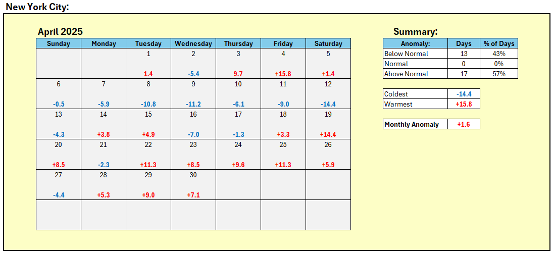
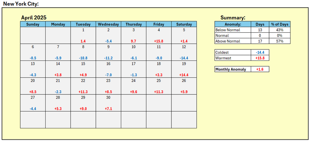
New York City's April Mean Temperature: 55.3° (1.6° above normal).
-
Down to 37F here in E CT.
-
HWO mentions the potential for flash flooding for the eastern WV panhandle this afternoon and evening.
- 1 reply
-
- 1
-

-
39.7° Not even close.