All Activity
- Past hour
-
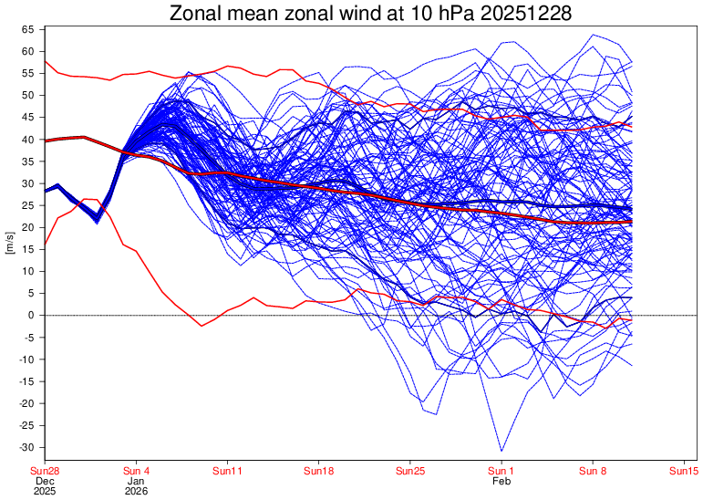
Check out how much weaker the SPV forecast is at 10 mb based on the 60N mean zonal wind on the Euro Weeklies! One week ago (12/21 run): quite strong just about all Jan through Feb 4th with no end in sight (mean 40-47 m/s): Today (12/28 run): near normal Jan 10th-Feb 11th (mean only 25-35):

-
Hard to get above normal precip if we have a -epo
-

E PA/NJ/DE Winter 2025-26 Obs/Discussion
Hurricane Agnes replied to LVblizzard's topic in Philadelphia Region
I just went up a degree. It has been hovering around 32/33 for hours and whatever frozen was sitting on/in my weather station rain gauge spout, has begun to melt and tip the bucket (at 0.07" at post time). Had bottomed out at 23 just after 2 am and am currently at my high of 34, with changeable skies (have had sun pop in and out today). Have been watching that precip field but have had nothing but virga here when the sun wasn't out. -
A lot colder euro weeklies today on the East Coast!
-

2025-2026 ENSO
michsnowfreak replied to 40/70 Benchmark's topic in Weather Forecasting and Discussion
Weeklies continue to show cold in the Great Lakes the entire run. The widespread cold signal for Jan 19-26 is very stark for so far out. -
Happy to hear that. AllSnow had a distinctive voice in these forums, it is missed.
-

Ice Ice Baby December 28-29 Storm Discussion
CT Valley Snowman replied to Baroclinic Zone's topic in New England
29 here under cloudy skies. -
Eh I don't pay much attention to temps on the extended products. I will roll with this h5 look mid-late month with an impressive EPO ridge and a stretched TPV- that's a cold look if you follow the flow. Also a gradient pattern with a flat SE ridge where waves can track along the boundary that should be to our south at times. Also hints at a -NAO and low heights in the 50-50 region.
-
down time ? I am currently under a Winter Weather Advisory
-
Trash night…sweet!
-
Yeah I don't know about this dude...I'm willing to see more next year before making a judgment, but dumbdy-dumb decisions like that make you wonder.
-
Can’t take away what we never had bud. Wild that you live and die off these 300 hour clown maps each day. Must be stressful
-
CAD doing its magic in NC! I’m jealous of you caddies. Consider that here it is still 70.8 here (with overcast). But even this is better than high 70s with sunny 24 hours ago and better than earlier this afternoon. This contrast between GA and NC was forecasted quite well. Yesterday’s high at KSAV was a sweaty record tying 80.
-
Had a little coating of snow/freezing fog this morning. I don't know what to call it? Lasted till about 9:30 am. Coated all surfaces, including roads. High today was 32.0. Temp dropping now. Down to 30.4, which I don't like with possible freezing rain coming in.
-
glad you posted this in the banter thread
-

Ice Ice Baby December 28-29 Storm Discussion
wxeyeNH replied to Baroclinic Zone's topic in New England
I just noticed that the NWS upgraded my area to a Winter Storm Warning. I know Dendy was not overly impressed yesterday and Tip for several reasons was not impressed earlier. It is currently 34/14F. Any changes in thoughts or basically just some slippery roads and some glazing but not enough for power concerns etc. -

E PA/NJ/DE Winter 2025-26 Obs/Discussion
PhiEaglesfan712 replied to LVblizzard's topic in Philadelphia Region
I was iced last January, as well as in late February/early March 2015. -
Definitely agree with your data backed analysis lolol
-
He's doing fine
-
Euro weeklies are still below or around normal, but have lost the AN precip during the 2nd period to a little BN unfortunately.
-
Dumbest throw I have ever seen.
-
Terrible. Sanders was a 5th round pick for a reason.
-
Snow finally filled in along the shore. Starting to accum now.
-

Central PA Winter 25/26 Discussion and Obs
Itstrainingtime replied to MAG5035's topic in Upstate New York/Pennsylvania
How much is expected? -
Tomer Burg @burgwx Very much in alignment here - not sure exactly when things fully kick off but once they do I suspect we'll have at least a 2-3 week window more favorable for moderate-major snowstorms vs. climo. South of NYC is likely more favored than north of NYC given Greenland block climo, but too soon to specifically rule NYC nor anyone else out. 12:21 PM · Dec 28, 2025 · 1,663 Views


