All Activity
- Past hour
-
He’s moving in mysterious ways
-
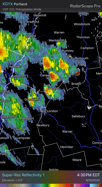
The rotational couplet is slamming the south side of the city. Too broad to be tornadic, but definitely local enhancement to the wind wrapping around.
-
Peak wind gust of 73MPH at MDW.
-
Peak wind gust of 61MPH here at ORD.
-
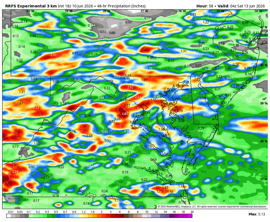
WB 18Z RRFS. More rain chances through Friday evening.
-
I would say yes if the clouds don't interfere. Boston and BDL got near 90 today. Worcester could only manage an 84°.
-
And a third time... and fourth time... can pick out the same two or three car alarms over and over
-
Central/southern part of the Chicago metro is getting rocked. Seeing a lot of 80-90 mph outbound bins from KLOT not too far off the deck.
-
Damn good storm imby. It wasn't one of those pours for 5 minutes and that's it. It kept coming and coming. It's still steady moderate rain and thundering. I'd estimate an inch or more. It was a classic thunderstorm.
-
Winds were howling but have slacked and it's gone pure dark jungle as the line approaches, v sick
-
Fuck load of car alarms just fell for it. I did too not gonna lie twice in 45 seconds now dude I thought it was kinda past already
-
Some rotation moving into Chicago. An inflow notch is visible.
-
Not fully shocked but that’s pretty robust from SPC at range
-
Got sorta split by this batch at home. Probably will be under 0.3” on the day. Hoco mesonet stations much higher.
-

Junorch obs and discussion 2026
Damage In Tolland replied to Damage In Tolland's topic in New England
Stein River East you think ? -
Yea that line was a gully washer. Curious to see if the stream next to my place is running again after that…it had dried up the last few days, though Catoctin Creek was flowing nicely 10 days ago when I crossed it to hike up Three Saws. There just hasn’t been any real precip issues here the last couple months…we’ve done pretty well in that department, relatively speaking.
-
Well I got what I wished for tbh can't complain from here Nice cold wind, pretty epic roll through overhead, let's do it again later
-
Hmmm (afternoon Day 3 update)
- 472 replies
-
- 1
-

-
- severe
- thunderstorms
- (and 7 more)
-
1.06 for the day; pleasant surprise.
-
Hello Afternoon Summer Thunderstorms! Been a long time! Sitting on the deck watching the storms roll in. Hoping for a direct hit, southern end of the line really perked up!
-
PDS Severe Thunderstorm Warning for the SW Chicago burbs
-
Storm seem to be intensifying as they near the Aberdeen proving ground. Will be interesting to see how the Upper Bay affects direction.
-
Another laughable miss this afternoon. .01" while areas 1 mile south and east got poured on.
-
This shows some of the 80mph+ wind reports and the extent of the squall line and some MPING damage reports
-

Central PA Summer 2026 Discussion/Obs Thread
Superstorm replied to Voyager's topic in Upstate New York/Pennsylvania
0.50” from first round .


