All Activity
- Past hour
-
Headlines up
-
Power out since 5 and tree down on a car with the wires but just 107 total outages so a small number and we are low priority. Plus it’s a Thursday holiday. The huge tree on University about 3 weeks ago put 900 out and we got prompt attention on that
-
Was in D.C. area this afternoon, numerous trees down and some unfortunately on cars that were on the roadway. Meanwhile back home 88 for a high.
-
Looks like dew points temps maxed out at 75/76 is the highest i see today. Slowly dropping now into the upper 60s.
-
 Paulmaxix joined the community
 -
What the hell kind of "storm" was this? For an enhanced risk? Fork found in kitchen.
-
High of 91. Dew points up near 80 made it feel like 110 at times. Can't wait until October.
-
Ended with around 0.52
-
Nice thunder and flashes off in the distance here at Killington, hopefully sticks together and I'll have to sacrifice the pop up shelter
-
Marine layer plus the air is further stabilized from the storm earlier.
-
.60" today
-
Managed to mostly split the gap earlier, but did get maybe a 0.1” from the south half of the line. Got to see 2 small shelf clouds though, and lots of lightning. Getting random showers now with some rumbles. Waiting for the random beginning of august impressive unexpected thunderstorm.
-
Man it’s a steam bath out there..we’re finally in it baby. I gotta take it nice and slow with the poor dog, though. She does struggle a little at her age with the heat.
-
Nice cool breeze out there. Enjoy it, it maybe the last time in a while.
- Today
-
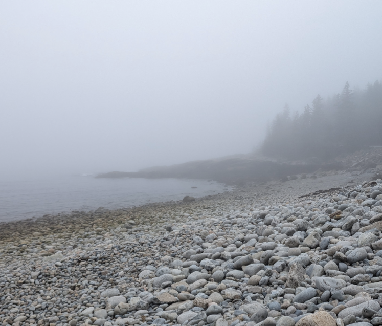
Yep. The place is a fog/rain forest. The water never really gets that warm. 60 plus maybe. We've done entire week long vacations and never seen the sun (pic attached was the last week of June in 2023). But often if you drive a few miles inland it can be sunny. Our relatives are across Frenchman Bay from Bar Harbor, and sometimes we can see the islands and town over there socked in with fog, while we have several mile visibility. August-September trend drier with less fog days but in the right set ups it's the same any month of the year. Anyway, hope you see the sun before you leave!
-
0.52", 2.72" for the month, 23.35" ytd, half way through the year this is pretty much average. Gonna need above average few months or wet fall to build the watertable back.
-
After yesterday's heavy rains and tornado sirens for 35mph gusts , today we got some fun tstorms with lots pea to marble+ sized hail and no warnings. Rain totals the past 2 days is almost 3".
-
Wednesday looks pleasant.
-
Lots of trees down from the afternoon storm here in Great Falls. Neighbors lost a big oak. Still lots of power outages. Fortunately ours was restored pretty quickly.
-
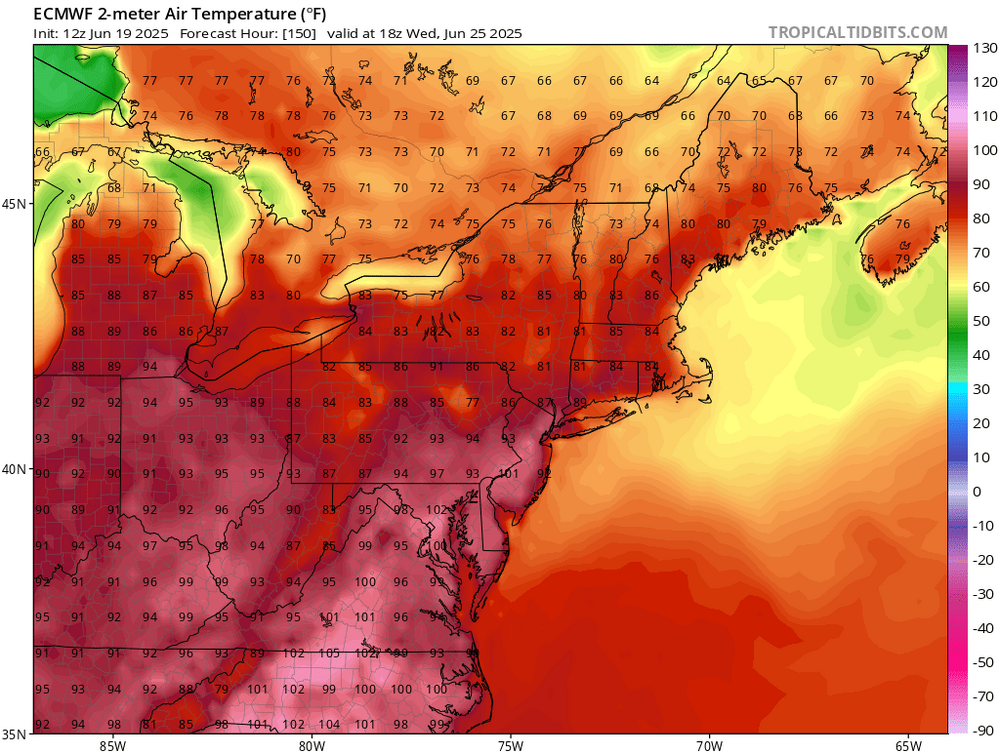
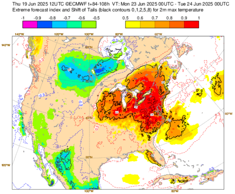
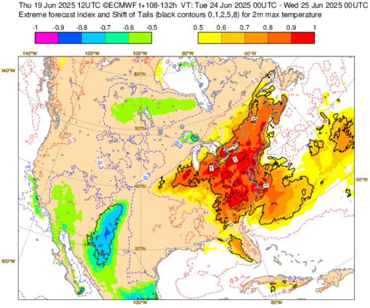
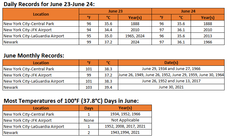
The operational ECMWF and GFS are now in good agreement that daily record temperatures will likely be challenged or broken during June 23-24 across the New York City region. June monthly records could be challenged, as well. EFI for June 23: EFI for June 24: Select Data:
-
Tons of small branches down across Eastern AA county as I assessed on my way into work. Crofton area had a bunch down as well along Rt3. Nothing too major seen on my assessment, but certainly took out some smaller dead branches in its path.
-

E PA/NJ/DE Summer 2025 Obs/Discussion
KamuSnow replied to Hurricane Agnes's topic in Philadelphia Region
Neighbor just west of us lost a couple, her trees probably saved some of ours.
-

2025 Severe Weather General Discussion
SomeguyfromTakomaPark replied to Kmlwx's topic in Mid Atlantic
Significant tree damage around takoma park. -
Up to 0.62" for the day and just over an inch since yesterday. Still some light rain to come through. Pretty respectable given all the misses this month.
-
lots of trees down and some very large ones too, I thought my windows were going to blow in that afternoon
-
88 here too, temperatures dropped after 12 noon


