All Activity
- Past hour
-
it is always surprising to see very hot temperatures occurring next to the warm front, regardless of it being a warm front. I have enough memories from being younger that thermal behavior was not like this, but i don't want to assume anything. It seemed like when it was very hot temperatures at a higher latitude, latitudes lower than it were also very hot. For many years now there have been so many instances of the hottest thermal activity jumping latitudes due to warm fronts and for one reason or another it feels like if this happened in the 1990s that it would be covered as an anomaly. But, did it actually used to happen as well ??
-
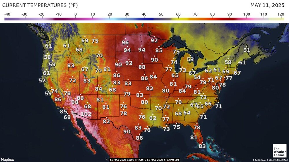
When this heat wave gets done with us by May 25th, all of central TX will be a burned out husk. I have a question for the pro Mets on here? Was 2011 Summer a NEG NEUTRAL ENSO? In 2011 entire forests burned in central Texas. It was like California in fire season. Because if it was, then this summer in Texas will be an INFERNO for sure. And, been real nice knowin' y'all.
-
We’ve reached 90 at MSP. Setting a new record high for today. There is a 200 acre wildfire burning north of @Brian Din Brimson MN. With the conditions the next few days it could get out of hand quickly if not contained.
-
Not wild about this. Hope the wind holds up. They will bump up when the wind decouples, but they’re still damn low.
-
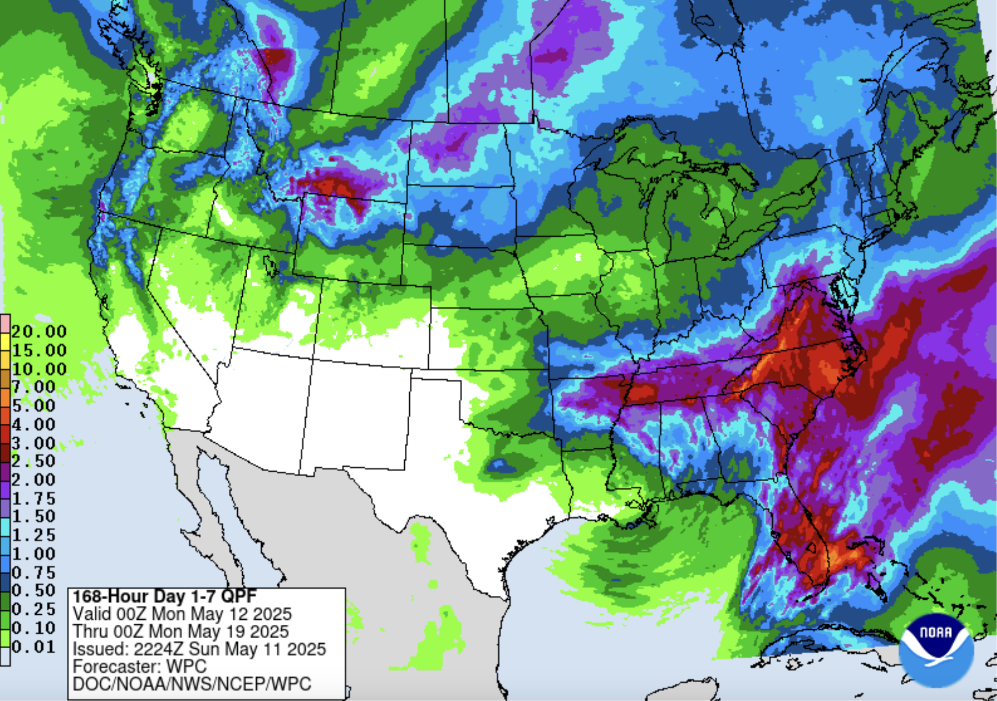
QPF looks good actually.

-
Starting a thread on this as the parameter space is fairly impressive with cape values exceeding 3500. looks like there will be an EML present which should keep convection limited and the 500-850 crossovers are favorable for discrete.
-
Oak dongs have begun there attack. Allergies engaged
-
RIP mom. You would have loved this day. .
-
Agreed! COC day up and down the coast. .
-
Closed the windows. The low humidity is making it feel a bit chilly.
-
I got another great (clear sky) sunset last night.
-
You’ll be fine . You’re not a huge radiator . Only places that will sniff 32 are like Norwood, Maple Hollow .. deep swampy sea level valleys . Most of those under advisory will hit 36 and someone will claim frost on their car roof to verify. These Mayorch frost advisories are always lol
-
May have a slight shot at mid 90s on Thursday here as dewpoints plunge in the afternoon.
-

2025-2026 ENSO
Stormchaserchuck1 replied to 40/70 Benchmark's topic in Weather Forecasting and Discussion
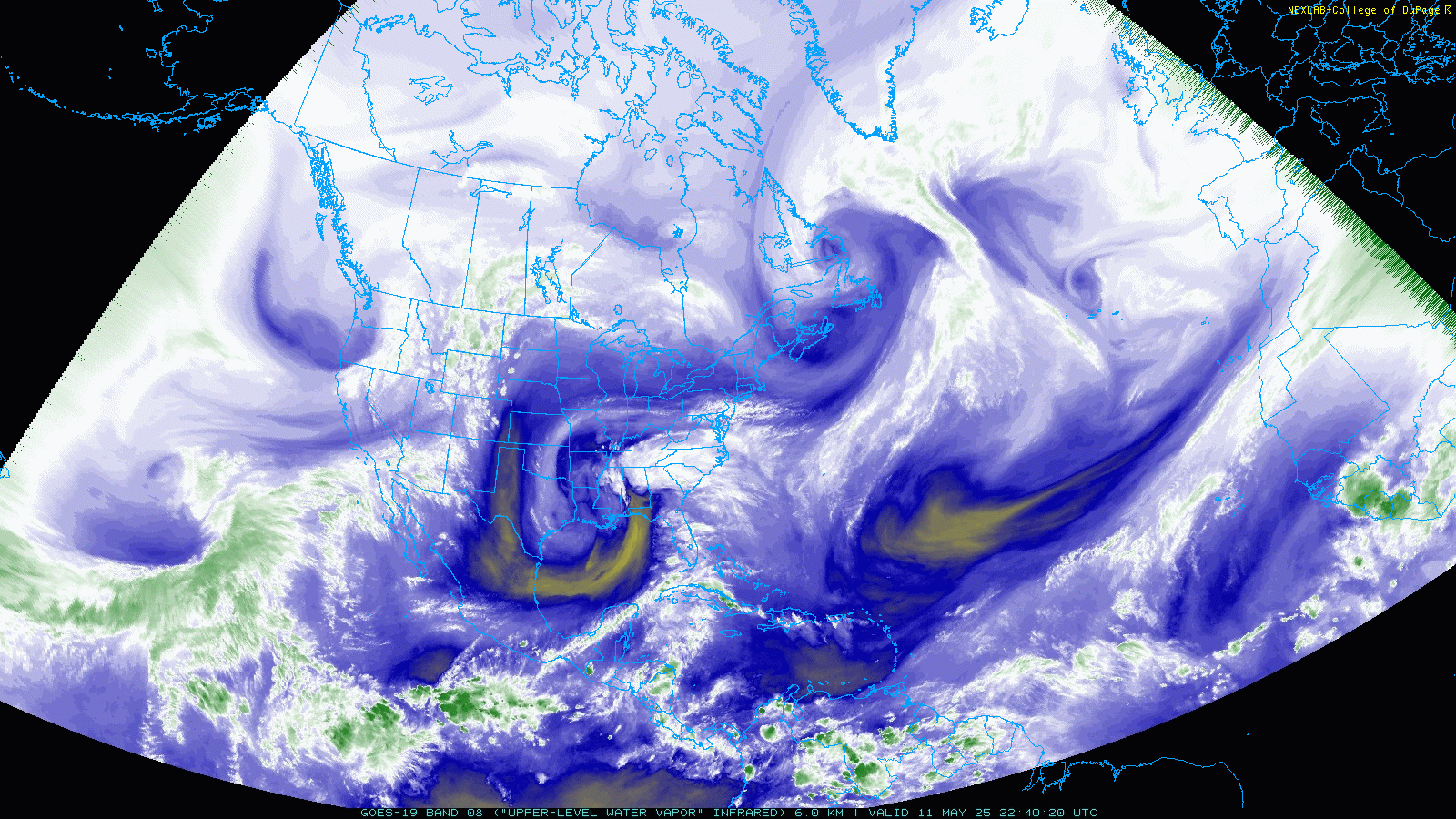
Nice progression of the warm pool on the CPC's subsurface -
If we keep getting these "drought busters" the area is going to become a desert. Instead we need a "build an ark" event in which case we might net half an inch.
- Today
-
You know, GFS actually looks better compared to its runs yesterday.
-

Spring 2025 Medium/Long Range Discussion
Powerball replied to Chicago Storm's topic in Lakes/Ohio Valley
^^^Fine with me!!! -
Higher terrain to the west, esp upslope areas. Probably not in the metros. 12z Euro probably has the right idea. LOL Gulf of America in a NWS AFD. Pathetic.
-
Guess that means the hatch will happen shortly. I had my first humming bird today at my feeder. Showed up yesterday, but I only got my feeder out today
-
Under bright sunshine, the mercury rose into the middle and upper 70s across the New York City area. Newark topped out at 81°. Tomorrow through much of Tuesday will be dry and pleasant days. Temperatures will generally top out in the lower 70s. Showers and/or thundershowers are possible Tuesday night into Wednesday. It will turn somewhat warmer on Thursday and the week could end with temperatures in the upper 70s to perhaps 80°. Meanwhile, parts of Texas will see extreme heat. The temperature could approach or set new May monthly high temperature records in such cities as Austin, Del Rio and San Antonio. The extended guidance has grown cooler for the second half of May than it had been. Both the CFSv2 and ECMWF weekly guidance are now in good agreement that the second half of the month could average near normal overall. The ENSO Region 1+2 anomaly was +0.1°C and the Region 3.4 anomaly was -0.1°C for the week centered around April 30. For the past six weeks, the ENSO Region 1+2 anomaly has averaged +0.68°C and the ENSO Region 3.4 anomaly has averaged -0.05°C. Neutral ENSO conditions will likely continue through at least early summer. Early indications are that summer 2025 will be warmer than normal in the New York City and Philadelphia areas. The potential exists for a much warmer than normal summer (more than 1° above normal). The SOI was -11.85 today. The preliminary Arctic Oscillation (AO) was +1.173 today. Based on sensitivity analysis applied to the latest guidance, there is an implied near 76% probability that New York City will have a warmer than normal May (1991-2020 normal). May will likely finish with a mean temperature near 65.7° (2.5° above normal).
-
Would fit well with our little local "tornado alley" down near EZF and across the bay into the La Plata/Southern Maryland area. Seems some of the guidance (not that it matters much at this range) wants to push the main threat to our south. That AI convective NCAR page is honking a bit for the Fri-->Sat timeframe though.
-
They’re already out here
-
Omg, if this wind would go away, today would have been perfect. Definitely dry, cold season airmass. Temp got up to 58 but it's chilly. Low temp overnight is 30-31 degrees. I'm super excited for tomorrow through Wednesday! I assume the black flies should be hatching shortly, but no swarms yet, so yay for that!
-
77 today
-

Central PA Spring 2025
Itstrainingtime replied to canderson's topic in Upstate New York/Pennsylvania
10/10 weather weekend regardless of what time of the year - just perfect weather to get outside.