All Activity
- Past hour
-
The PDO has a crossover effect on this. Unless we get a 1996 type fluke (very unlikely in the current PDO) a snowy winter is off the table. It’s going to be hostile. But how hostile matters. One of the biggest factors determining between a god awful or just meh winter will be the PDO. If it’s closer to -1 for the winter like last year we have a shot. If it’s hanging out around -2 to -3 we’re in trouble. But it didn’t really start to improve until around thanksgiving last year so we won’t know for a while. But it’s not just the models. Red is crushing blue in areal coverage at our latitude overall lately. And no it doesn’t mean we can’t get a snowy winter. But it does make them less likely.
-
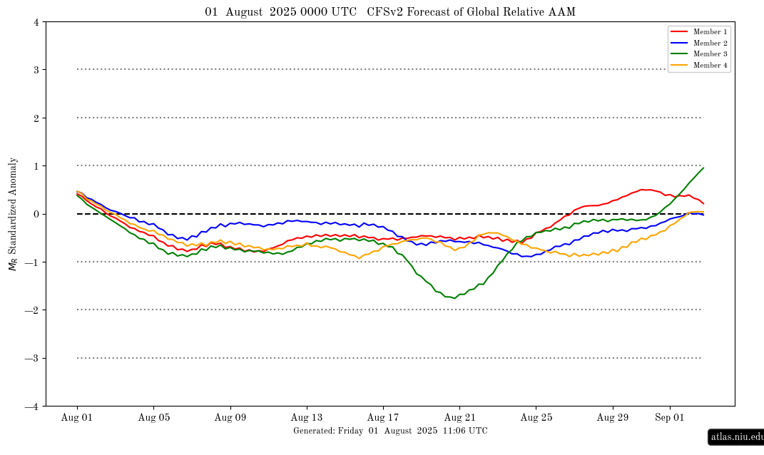
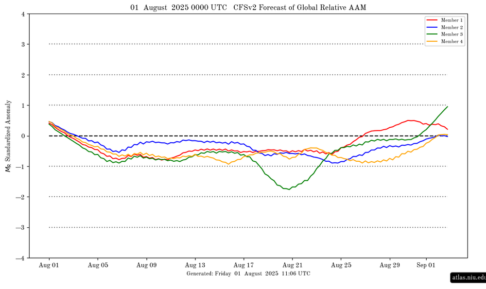
AAM finally going - (Ninaish):
-
I think Mother Nature heard your comments about the lack of rain in Marion @wncsnow
-
Overperformed to 27C/80F with low dews and fresh air on Fri. For a few days now WUN has 30C/86F continuously maybe starting Mon if we exceed by 2, all the way til the last slot on Mon the 11th! What a magnificent stretch it'd be.
-
It was steaming
-
 58.6 this am. Nice and crisp
 -
Wow what a region-wide soaker! Almost everyone participated. Some jabroni was asking if it was even going to rain lolz.
-
You wonder if today was coolest till mid/ late Octorcher
-
With a torch fall coming, gonna be speedos until Halloweenie.
-
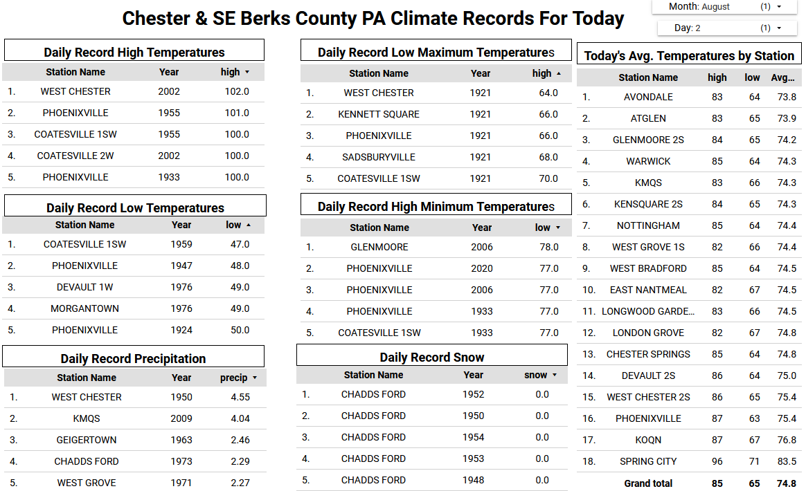
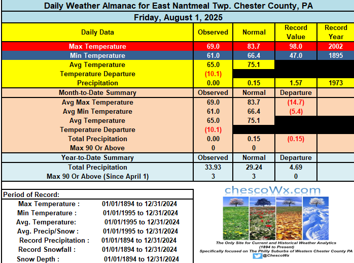
Yesterday was the 5th chilliest low maximum temperature for the date with highs remaining in the 60's at Atglen, West Grove and East Nantmeal and just past 70 degrees at most other locations. We should remain below normal today but with highs a good 8 to 10 degrees above yesterday. A great weather week ahead with temperatures at or a bit below normal for the first week of August. Low's this morning were in the 50's with the lowest at Warwick Twp. at 54.8 degrees. Lows continue in the 50's the next couple of nights with lows not too far from 60 for the rest of this week. So a great break for all of our A.C.'s.

-

E PA/NJ/DE Summer 2025 Obs/Discussion
ChescoWx replied to Hurricane Agnes's topic in Philadelphia Region
Yesterday was the 5th chilliest low maximum temperature for the date with highs remaining in the 60's at Atglen, West Grove and East Nantmeal and just past 70 degrees at most other locations. We should remain below normal today but with highs a good 8 to 10 degrees above yesterday. A great weather week ahead with temperatures at or a bit below normal for the first week of August. Low's this morning were in the 50's with the lowest at Warwick Twp. at 54.8 degrees. Lows continue in the 50's the next couple of nights with lows not too far from 60 for the rest of this week. So a great break for all of our A.C.'s.
-

Central PA Summer 2025
Mount Joy Snowman replied to Voyager's topic in Upstate New York/Pennsylvania
Low of 56. My weekend is inundated with kids birthday parties. Hoping to find time to make a fire one night. -
Noticed yesterday that the leaves on the Tulip trees were looking a littler leathery and ragged.
-
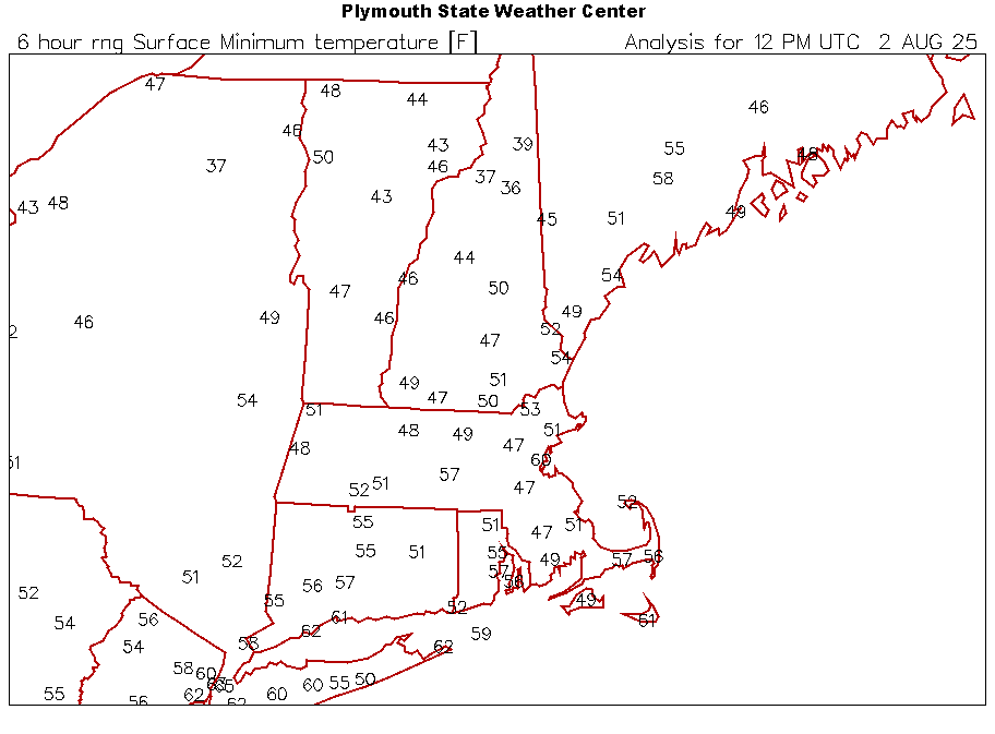
Mins this morning
-
It’s warmer in the pool
-
At least Camden yards will sell out every game this weekend lol
-
Beautiful morning.
-
Good. Keep lower Delmarva dry.
-
 What time are we expecting smoke
 - Today
-
Glorious morning in Marysville with a low of 56. Currently temp is 65 with a beautiful dew point of 55. Welcome to the last month of Met Summer! I am starting to see the finish line…
-

2025 Spring/Summer Mountain Thread
Met1985 replied to Maggie Valley Steve's topic in Southeastern States
Freaking beautiful -
 We'll see if something deepens underneath the building ridge in the weakness offshore
 -
Lol, not until October, at least, but I’m sure looking forward to snow map season!
-
Phenomenal sleeping weather.