All Activity
- Past hour
-
 12z Hrrr is a tease for SWCT with a sunrise surprise tomorrow … Aint happening James
 -
Low 26
-

November 2025 general discussions and probable topic derailings ...
Lava Rock replied to Typhoon Tip's topic in New England
well that was a bit of an annoying outage. -

November 2025 general discussions and probable topic derailings ...
dendrite replied to Typhoon Tip's topic in New England
I’m trying to think back to the last time we had a cloudflare outage and how the following winter ended up. There’s still time for Ray to make some minor adjustments. -

Occasional Thoughts on Climate Change
WolfStock1 replied to donsutherland1's topic in Climate Change
Perhaps Vogtle is an outlier, but it's still clear that costs are way above where they should be, based on the skyrocketing trend in the late 80's; and noting that that was generally for just completion of plants whose initial planning and design was done *before* TMI. Not sure what you mean by "the workforce" being the primary road block. Workforce expertise is flexible - if we started getting serious about nuclear energy and ramping it up, the workforce would follow, just like it has always done for so many other things (e.g. look at the explosion in AI recently, the explosion of the internet in the late 90's, etc. etc.). Demand creates the workforce - the workforce doesn't create demand. -

November 2025 general discussions and probable topic derailings ...
CoastalWx replied to Typhoon Tip's topic in New England
Need Tip to describe them. -

Central PA Fall Discussions and Obs
Mount Joy Snowman replied to ChescoWx's topic in Upstate New York/Pennsylvania
31 when I left the house. Site was down this morning when I initially tried to post. -
November 2025 general discussions and probable topic derailings ...
dendrite replied to Typhoon Tip's topic in New England
Did you like them? -
Ok that explains it. From 2002 to now, NYC has had 12 winters above 30", but the prior 32 winters, only 4. I think that stretch from 2002-present, but really 2002-2016, really skewed peoples expectations. This is correct. Often the area is between 15-25", but those bigger winters is what we crave.
-
To me, NYC has a very snowy climate. Then again, my avg annual snow is only 0.2” with most winters getting none. My area hasn’t received a foot+ of snow for an entire season since 1800. I’ve also lived in Atlanta, where their avg is still “only” 2”. So, when I see a city’s average at 20”+, ten+ times as much as ATL and 100+ times as much as SAV, that there is very snowy! Atlanta’s never even gotten close to 20” in a season! Aside: Cloudflare problems had been causing widespread outages this morning, including here.
-
nice! yeah its a really easy way to spend an hour or two when i should be studying, to waste time. grand forks does seem a little trigger happy on their eastern counties there...
-
Jeff Beradelli has stated that sudden stratospheric warming will begin today, dropping a polar vortex into the northeast by early next month.
-

December 2025 Short/Medium Range Forecast Thread
nrgjeff replied to John1122's topic in Tennessee Valley
Glad 2005-06 came up. December got nutty cold. Snow blanketed much of the country. Then it got warm. December cold broke around Christmas in KCMO, which was a little disappointing. January thaw was torch. For this year, operational models are of course all over the place. Thanksgiving weekend cold front CF may actually be faster on Thanksgiving rather than the weekend. Then a few milder days are forecast before the next CF. Weekly products the CFS gets cold established for the first week of Dec, fading during the second week of Dec. The ECMWF weekly doesn't seem to acknowledge the Thanksgiving weekend CF but starts the cold west to east trek the first weekend of Dec. Putting it all together, I think the first 1-2 fronts could be brief cold intrusions. Thanksgiving weekend and then middle of the first week or weekend of December. ECMWF weekly struggles to discern the fronts that week. CFS may lock in cold a week early. Perhaps after a couple fronts chip away at the warm pattern, by December 10 give or take a couple weeks can average truly below normal temps. See if we could get that through Christmas for a third week. Siberia continues to set the table.. for after we work through the North America warm week to 10 days. Temperature anomalies, blue is cold Sfc Press anomalies, red is higher
-
29.8
-
Low of 23.5 at 6:59 this morning. Just finished my last morning doing my friends farm. Was all layered up but by the time I was finished had peeled off almost all my layers.
-
November 2025 general discussions and probable topic derailings ...
dendrite replied to Typhoon Tip's topic in New England
Most dramatic cloud action of the winter? -

E PA/NJ/DE Autumn 2025 Obs/Discussion
Mikeymac5306 replied to PhiEaglesfan712's topic in Philadelphia Region
I remember (maybe in the MA forum) talk of the first legit winter storm was in the first week of December. Welp. Fantasy land 6Z has it. Albeit nothing to go crazy over. -
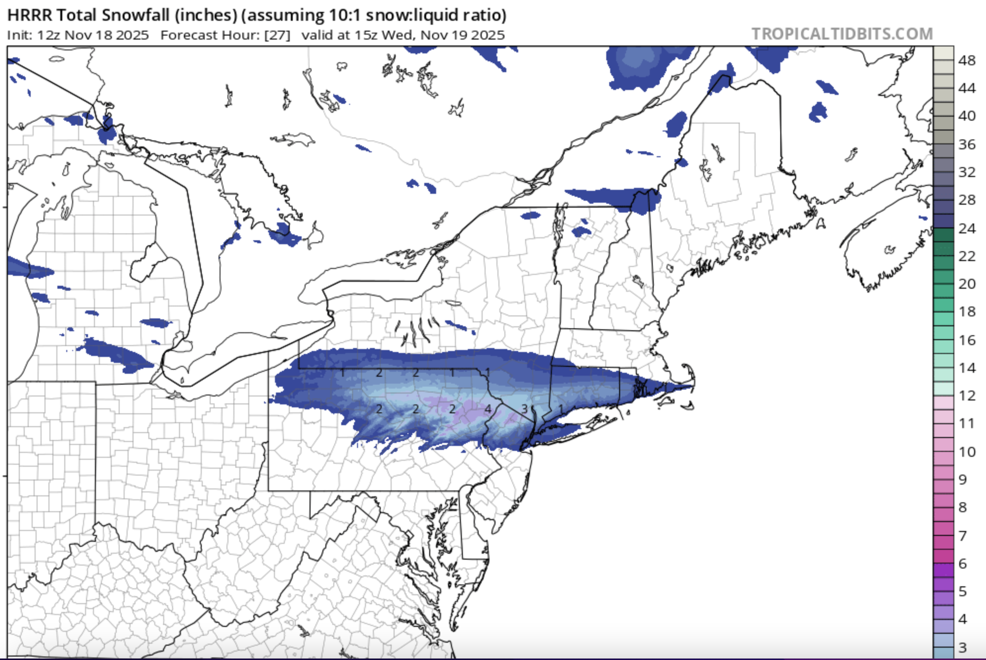
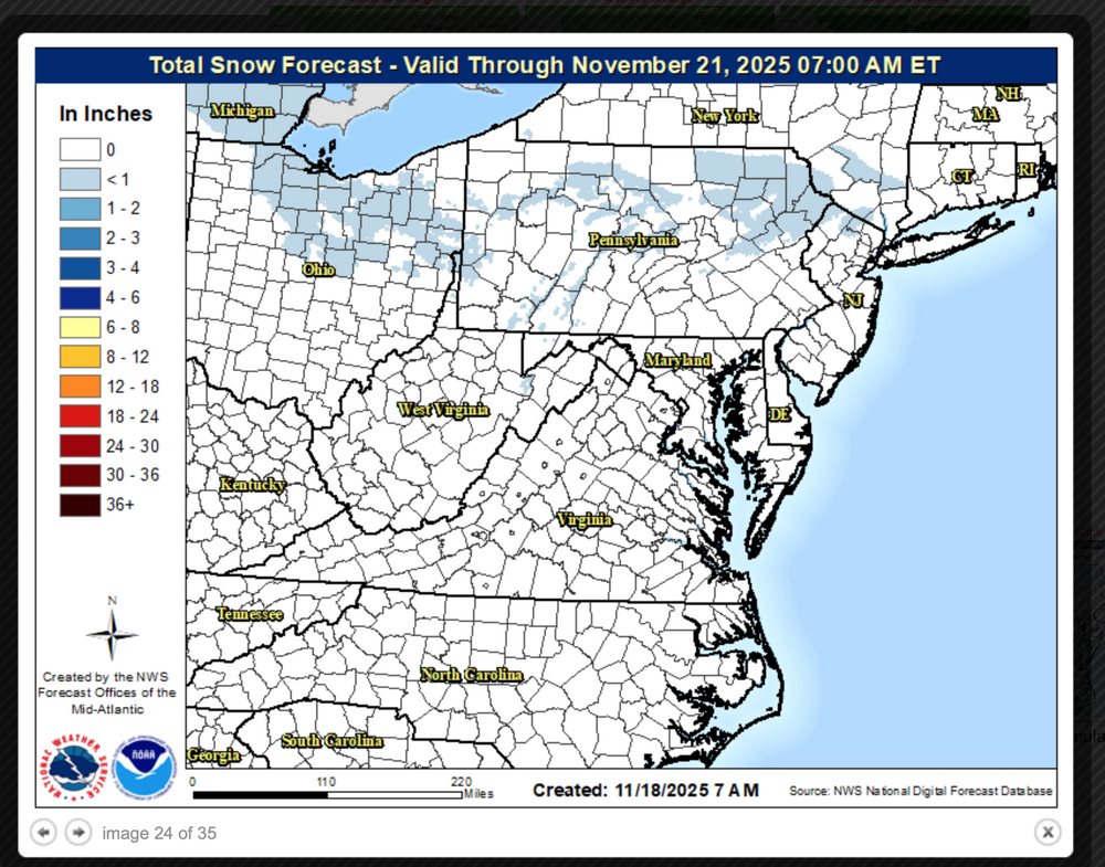
Well here's the thing... Globals overall have not held onto the structure of the oncoming short wave into confluence zone in NYS New England so have been depressed. 6z EC topped in favor of the 06-09z RRSFA, RAP, NAM3K and 12z HRRR. I sure hope the 12z/18 HRRR is not that far wrong... it could be too aggressive to the north but I expect a 2-4" stripe somewhere near I80 which would be a little south of the 12z HRRR axis. Uncertainty of course but we have to make decisions on what we do. So potentially embarrassing if it fails but this is what I updated locally. Updating I84 corridor 9AM. Plowing will probably be needed for at least the higher elevations tomorrow morning from northeast PA through nw NJ/se NYS into at least southern CT and possibly Hartford Ashford. Too much short term modeling that is at the leading edge of mesoscale modeling is upping amounts and predicting a decent 5 hour event that will require adjusted traveling times. Entire I84 region from the Poconos across nw NJ, se NYS into ag least the southern two thirds of CT 1AM-9AM Wednesday (tomorrow) morning. A 3-6 hour period of wet snow that likely accumulates 1-4"-especially grass. Valley roads 600 feet or below just wet because of temps just above freezing but accumulations on untreated pavements expected for the hills where the temp will drop to 30, especially 1000 feet or higher. The northern extent of the snow shield is a little uncertain but prepare for slower travel-delays in your early Wednesday morning travel. In my opinion there is an increasing chance of a 2 hour delay for high terrain schools I80 northward. Overall minor impact anticipated except during a period of heavier snow near dawn. The southern extent of snow somewhere between I80 and I78 and it probably will melt on most pavements south of I80. Monitor NWS forecasts and any advisory in their afternoon issuances. I suspect that their forecasts will become more formidable for our second accumulative snowfall of the season...and pavement covering too. I just dont think a 30-40% chc of precipitation covers it for tonight in nw NJ-NYC. Graphics are the NWS 7A snowfall forecast and the 12z HRRR which sort of mirrors the more conservative 06z EC. Click for clarity.

-
Its not a snowy climate but we do get big snowstorms once in a while.
-
Low of 24, coldest so far
-
Sorry lived in FL before 2022. Thus I have not seen first hand evidence that this place can be snowy.
-
29.5° in Havre de Grace. More interestingly almost everywhere was below freezing for 8+ hours.
-
0.48" here, on the high end of the model range. Up to 0.90" fell on the northeast edge of the city. It came with some decent lightning/thunder.
-
low 27
-
low of 29 in mclean


.thumb.jpg.ad3a2e31d30aff035044689b311a0540.jpg)