All Activity
- Past hour
-
Yes, they haven't updated the spreadsheet since July 1, so I suspect they've swapped out most by this point. Just wondering if there's been any cool bias? I would argue, yes, but I'm wondering if anyone else has noticed this. It looks like the stations that were running on legacy sensors did much better for heat early on this summer versus the stations that had swapped in the new sensors.
-

September 2025 OBS-Discussion centered NYC subforum
PhiEaglesfan712 replied to wdrag's topic in New York City Metro
This is as good as you're going to get at this time of year. Watch us have 100-degree heat at this time next year. -
2025-2026 ENSO
PhiEaglesfan712 replied to 40/70 Benchmark's topic in Weather Forecasting and Discussion
FWIW, the last 2 -IODs that were as strong as this year torched in November-February. The only difference is that (outside of Baltimore and DC), we got the blizzard in mid-March 2017, otherwise 16-17 would have been a snow shutout like 22-23. The big difference this time around is that we had a cool August (2016 and 2022 had record warm Augusts).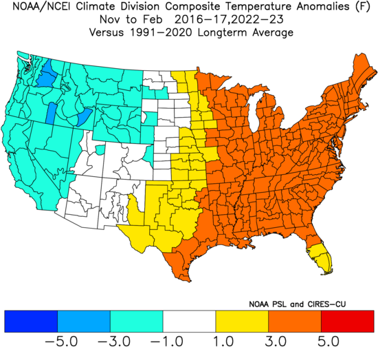
-
lol, I'm not risking the well. the "lawn" at this point can continue to hibernate
-
I don't believe it's happened yet. Last I heard there was an issue at one of the test sites that caused them to pause the replacement plan, but that was like 9-10 months ago back when we weren't trying to cut NOAA's already meager funding in half. EDIT: Looks like they have begun to roll some out to southern region stations. EDIT2: On second look, it looks like they are done with half of the stations. Around here: BDL, HFD, IJD, ACK, BED, BOS, BVY, FIT, HYA, MVY, ORH, TAN, PVD, UUU, WST, and PYM.
-
There are outliers to every subset but Nina’s in general are colder and drier than other enso states lately. That produces less variance across our region due to meso scale climate factors (elevation, slight changes in latitude). So in general that equates to better for places further SE in our region and worse for places NW wrt “normal”
-
any consideration to the nada model ?
-
Yeah, the issue is that failed harvests, catastrophic floods, other major disasters, etc, have all happened many times before and it's really impossible (and intellectually dishonest) to pin any single event directly to climate change. Now, if some regions started seeing repeated, mass casualty level heat waves, or as you said rising oceans began causing large scale flooding in major cities, then I think that would grab enough political attention to take serious action.
-
stream of smoke heading this way on satellite.
-
Starting to be like the snowstorm models
-
They dropped Erin a couple of times early in detection, too. just sayn'
-
One big difference tomorrow between the NAM and GFS is the difference in lapse rate in the lowest km. This could be the difference in getting damaging wind gusts that are more scattered/concentrated versus localized.
-
We are only in September. Winter outlooks by the models and people for the past few years haven't been good. Grain of salt this far out
-
Just saw a video from a met from NH of the Saco. She had never seen it so low.
- Today
-
Meh
-
-
I have the WS-5000 and have had no complaints. In fact, with Energizer Lithium batteries I somehow have yet to have to change ANY of the sensor batteries...and it's been over 2 years I think. Has to happen eventually....they just keep going. I have a few temp sensors, a lightning one. Never installed the rain gauge because I don't have a good spot, and the wind direction is unreliable because it's not sighted properly - but for everything else it's been fantastic. The power supply for the console went haywire and died recently but got an Amazon replacement and it went back to normal.
-
Heading down to Karns for high school football this evening. It looks like the storms will arrive here after Friday night lights are done. At least I hope so.
-
@North Balti Zen Glad I could help! Lots of choices out there, but that Ambient is best bang for what it delivers and the accuracy component of it all. I know you want as close to perfect as possible, so that is a solid choice! I think you'll love it!
-
Sniffed this out firstly on Monday! Some knew ...Northeast... A wave of low pressure is forecast to develop over eastern PA early in the day, translating northeastward along the front and into ME by late afternoon. Stronger heating and steep low-level lapse rates should develop from VA into eastern PA/NJ and into interior southern New England, with MLCAPE around 1500 J/kg as an areal average. As the warm air mass develops and accelerates north ahead of the cold front, both instability and shear parameter space will become favorable for severe storms, including supercell potential. A line of storms is expected by 17 to 18Z, from eastern PA toward the Hudson Valley, expanding N/S and pushing east through the afternoon. Given 40-50 kt effective deep-layer shear and enhanced low-level shear with the midday surface theta-e surge, the initial storm mode may be cellular along the boundary, with a brief tornado or two possible along with some hail. Damaging winds are then most likely as outflows merge, and spread east across the remainder of the region through late afternoon.
-

O'Brother Septorcher
Prismshine Productions replied to Prismshine Productions's topic in New England
Same, .3 here Sent from my SM-S166V using Tapatalk -
If I were running the team, I would trade Jalen Carter as soon as possible, hopefully get a lot of picks out of it, and let someone else pay him in the offseason (and be their problem). We should have kept CJGJ instead. The difference between CJGJ and Carter is that CJGJ knows where the line is, and doesn't cross it. Can't say that about Carter.
-
My thought hasn’t changed on that so far. Although I was on board with 91L developing, I still think the basin overall will continue to be hostile until mid September or more likely after the 20th.
-
zzzzz
-
I would bet there's not even a trickle going thru there right now.


