All Activity
- Past hour
-
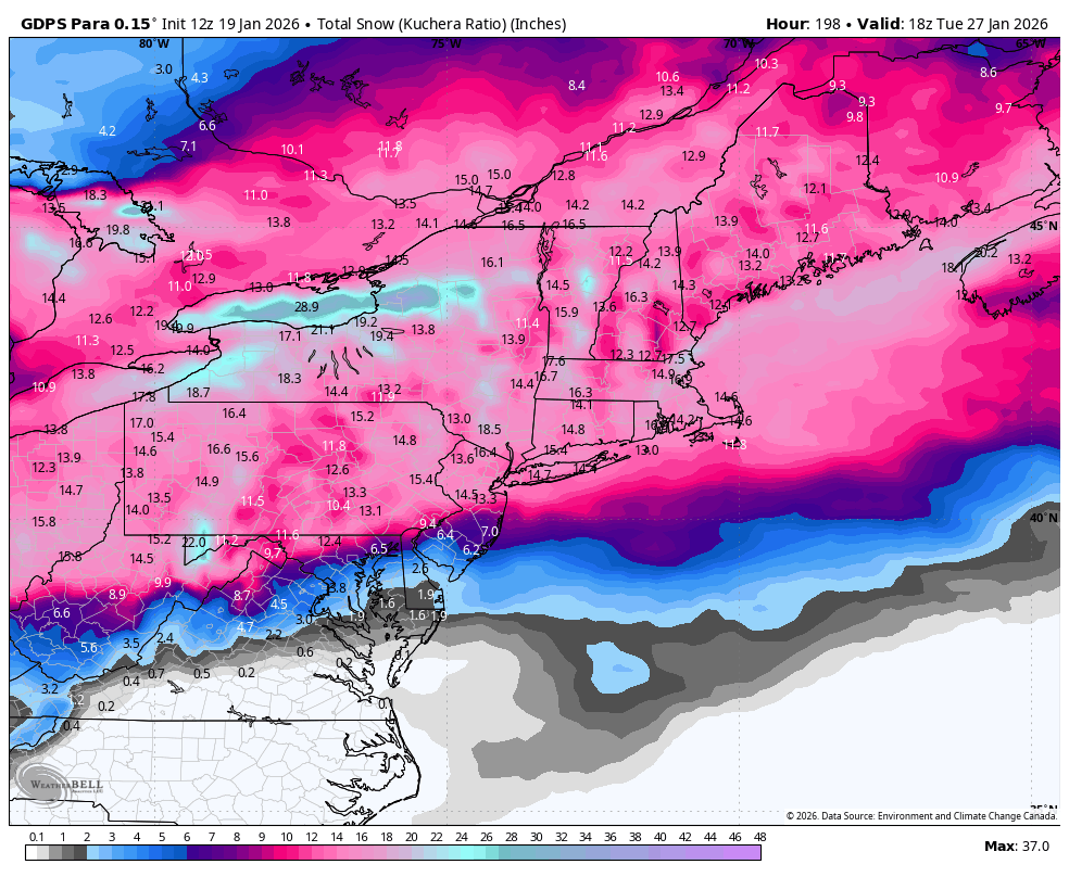
And Central Park does it again. You would think that their ratios should usually fall somewhere in between Newaks and LGA since they are located in the middle. This is only two events, so a skeptic might say it's just an aberration. Let me assure the doubters it isn't. This happens much more often than it should and rarely the other way around. It all comes down to being sloppy with when they take measurements, or don't at all. This is what happens when you don't have a professional manning the ruler (it's actually a pretty simple device to work with). Jan 2026 Weekend Event.pdf
-
THANK YOU
-
Ill have to check and i dont think we'll quite be in the single digitis in the city / metro areas byt of recent Jan 3 2014 comes to mind. Will need to check (low teens then)
-
Trends have been great today, but still leaning in he @WxUSAF camp and weighing towards the ensembles until we get inside HR 84.
-
TAKE YOUR WORDS BACK. Mother Nature isn’t capable of doing it, I don’t think she has that dog in her (reverse psychology).
-
So honest question is anyone really concerned about suppression with a 1053 high to the north?
-
I'm leaning suppression less because of what the OP models are showing this far out and more just the pattern/strength of high/depth of cold. I can't think of the last time NYC saw a significant snowstorm at 10 degrees, we don't have 90s climo anymore. Could it happen? sure I guess. It's also possible the models could be overdoing the high/cold etc.
-
EuriAI gives us 2 more monsters after this weekend while the Eps snowfall this run increases by 1.5" imby after this weekend! Lol wtf Sure hope technology wins this run.
-

January 2026 regional war/obs/disco thread
ORH_wxman replied to Baroclinic Zone's topic in New England
Had to be sub -40C stuff on a Montreal express trajectory. The perfect storm of ingredients to get those types of numbers. -
0z Sunday
-
Never say never
-
And showing the suppressed GFS isn't going to get clicks.
-
I will wait until Wednesday/Thursday to take the threat serious. We saw the flip flopping last storm
-

January 2026 regional war/obs/disco thread
dendrite replied to Baroclinic Zone's topic in New England
Yeah I’ll take the over on a high of -5° here. Although 5-10° wouldn’t surprise me. I’d love to know what the mid level temps were for 12/29/33. The afternoon high up here was -15°. That’s like 10° colder than anything else on record up here. -
https://x.com/AccuRayno/status/2013290491517743459 bernie rayno buys the euro AI the most, favoring nothern solutions, says there will be 15:1 ratios
-
Ummmm, You get your girlfriend to change her birthday to Tuesday
-
My goodness, 12z Euro Ai, CMC, GFS have the 2nd system coming into focus next wednesday.
-

January 2026 regional war/obs/disco thread
Sey-Mour Snow replied to Baroclinic Zone's topic in New England
Just a bone for the NNE crew. In Canada we trust ..
-
He's vegan, have some class.
-

Central PA Winter 25/26 Discussion and Obs
pasnownut replied to MAG5035's topic in Upstate New York/Pennsylvania
GFS....yeah you can laugh at that one CMC qpf distribution sounds close to euro AI??? Huhh Regardless...plenty of time for changes that will happen, for better or worse. -
It’s not possible, every single one of your posts are debbie downers. How could you actually be optimistic.
-
Welllll… this may not be the only one we are tracking. Carver may need a new coffee machine for the upcoming weeks. .
-

-

January 25/26 Jimbo Back Surgery Storm
WinstonSalemArlington replied to Jimbo!'s topic in Southeastern States
it’s been a while since we’ve been at 90-100% chance of greater than an inch five days out -

E PA/NJ/DE Winter 2025-26 Obs/Discussion
Newman replied to LVblizzard's topic in Philadelphia Region
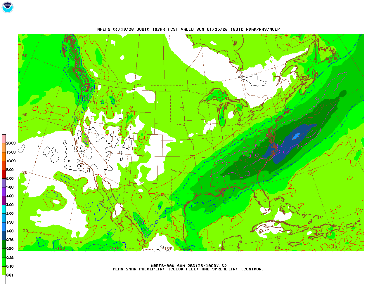
This was a great shift north on the NAEFS from 0z to 12z. I've found that the NAEFS are just as useful as some of our other ensembles because they take the CMC and GFS guidance combined. It's sorta like a North American specific grand ensemble. Just SE of I-95/Philly jumped from 0.25 to 0.5" of QPF. 0.25" extends well up towards I-80 now. Obviously jumping ahead a bit here, but for those who end up on the northern side of the precip shield and aren't smoking cirrus, you'll usually have a solid 700mb fronto band set up and can eek out additional inches that way.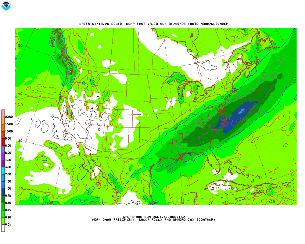


.thumb.jpg.9707d4addca3d84715ae3d888c5c10d6.jpg)