All Activity
- Past hour
-
6z Euro is congrats Dendrite for Wed but then a qpf inch plus of snow on SNE Friday Saturday
-

Early Monday morning 2/16 last minute event OBS/Discussion
BBasile replied to The Iceman's topic in Philadelphia Region
0.33" of rain. -

Presidents' day Snow potential
weathermedic replied to WeatherGeek2025's topic in New York City Metro
Picked up 1" on colder surfaces. Temp made it down to 30 at my station in Sheepshead Bay Brooklyn -

Is we back? February discussion thread
Damage In Tolland replied to mahk_webstah's topic in New England
That Sunday night storm has some eps support but that setup the GFS shows is shaky -

Presidents' day Snow potential
sussexcountyobs replied to WeatherGeek2025's topic in New York City Metro
Picked up .7" last night -
6z GEFS has it.
-
-

Presidents' day Snow potential
coastalplainsnowman replied to WeatherGeek2025's topic in New York City Metro
From the lack of observations I'm guessing this was one of those rare south shore specials? 2.5" (maybe slightly more) on grassy surfaces. 1.5 on the sidewalk. Clung to everything too. While there's definitely pavement showing on my side street, it's a bit of a snowy/slushy mess. Will enjoy the look before it's gone by this afternoon. Nice little event here. -
Staying power will be in the freaking middle of Spring I bet.
-

-
What little rain we got was beneficial for the forrest fires.
-
Pretty big model battle underway for day 2.5. Skynet could be way out to lunch here or would be a helluva coup if this whiffs n of the pike. Gfs is just right.
-
0.69"
-
Soon
-

Central PA Winter 25/26 Discussion and Obs
mahantango#1 replied to MAG5035's topic in Upstate New York/Pennsylvania
Congrats on this astounding snow victory! -
When does today’s snow start?
-

Presidents' day Snow potential
donsutherland1 replied to WeatherGeek2025's topic in New York City Metro
Overnight, New York City received 0.08" of precipitation. The 0z HRRR followed closely by the 0z GGEM did best with the final amount.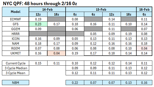
-
This will be a great pattern for the West coming up. Very fast Pacific flow with plenty of snowfall in those areas. Poor storm separation between systems crossing the CONUS. So any coastal storms tracking to our south run a suppression risk with kicker lows coming into the West Coast. The warmer further north systems will tend to cut or hug.
-
Accumulating snow ended up not too far away from N and NE MD last night. A fair number of 2-4" reports up near west Chester and areas WNW of Philly.
-
Euro AI doesn't support it
-
Let's just get the 6z gfs and call it a winter
-
1” flat here in bed stuy Brooklyn. 24.7” on the season
-
The Big California Blizzard of 2026 is taking its sweet time getting to the Sierran Resorts this morning but it's still on track. Light snow has started at Mammoth and steady driving snows are accumulating at Palisades Tahoe Resort farther north. The 8200 foot Scope at Tahoe shows high winds blowing a drift on the Scope Platform. As the day wears on temperatures will remain in the low 20s along with strong winds gusting to 60 mph, well over 100 mph at the ridges. Snow will continue and become very heavy with rates increasing to 2-3 inches per hour. Massive amounts of Pacific moisture will be hurled against the Cordillera and forced 11000 feet into the atmosphere resulting in torrential snows that will train for hours and hours and hours. Snow will rapidly pile up and strong 50 to 60 mph winds will blow the snow all over the place, at times resembling a milkshake froth with near zero forward visibility and serious whiteouts that will make it quite possible for travelers to get lost in and then easily freeze to death in very similar to Luke Skywalker on Hoth. Huge brobdingnagian cornices will form on numerous ridges greatly increasing avalanche dangers throughout the Sierras for the next 4 days. I expect both Tahoe and Mammoth will be shut down out of an abundance of caution probably by Tuesday as ridiculous snow rates continue to pile up. Radar shows a huge blob of yellow slamming hard directly against the Sierras. This blob is just undulating and constantly being resupplied by more moisture off the Pacific storm system. The entire region is in for a tremendously overwhelming amount of snow; some communities are forecast to see possibly as much as EIGHT FEET of new snow by early Friday. This is no time to be anywhere in the disaster region. Palisades Tahoe Live Webcams: https://www.palisadestahoe.com/mountain-information/webcams#tab=palisades Mammoth Resort Woolly Lot Cam: https://www.mammothmountain.com/on-the-mountain/mammoth-webcam/woolly-cam Mammoth Resort Main Lodge Cam https://www.mammothmountain.com/on-the-mountain/mammoth-webcam/main-lodge They are not using the big lights at the Main Lodge any more but they have enough lights near the building to see the snow coming down.
-
Is we back? February discussion thread
Damage In Tolland replied to mahk_webstah's topic in New England
What about Wednesday and Friday? AI’s are colder for Wednesday -
2 inches of new snow here. that is on the existing snow and car tops, pavement far less.