All Activity
- Past hour
-
Wizards have the #1 pick in the draft
-
Next weekend’s temps look very appealing. Hopefully the start of a new pattern that brings in the type of humidity that makes the mid Atlantic, the mid Atlantic.
-
Getting quite active all over. Could be one of those sneaky good days.
-
started off cool this morning but once the sun broke through the clouds it got warm humid pretty fast.
-
Radar looks subpar. Gonna need a new pattern. Bring on summer.
-
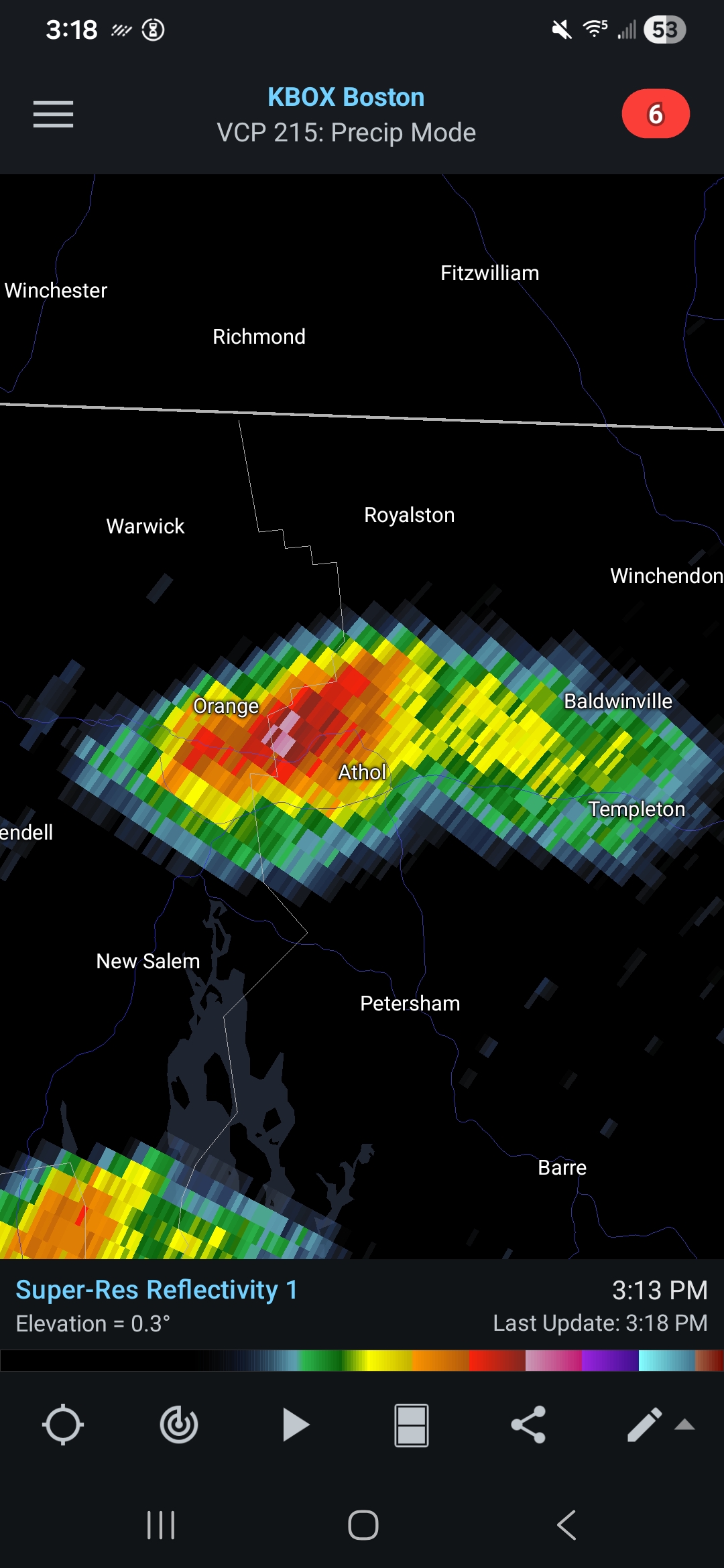
This popped up quick LFG

-

2026-2027 Strong/Super El Nino
Stormchaserchuck1 replied to Stormchaserchuck1's topic in Weather Forecasting and Discussion
Not really seeing much of a N. Pacific low or negative anomaly in the NPH area (-NOI) thus far. -

Central PA Spring 2026 Discussion/Obs Thread
Itstrainingtime replied to Voyager's topic in Upstate New York/Pennsylvania
It'll be very short lived but an impressive little punch nonetheless. -

Central PA Spring 2026 Discussion/Obs Thread
canderson replied to Voyager's topic in Upstate New York/Pennsylvania
I said the exact same this morning as we walked into church. -
Central PA Spring 2026 Discussion/Obs Thread
Itstrainingtime replied to Voyager's topic in Upstate New York/Pennsylvania
70/64 with a light shower in progress. Humidity caught me off guard this afternoon. -
Wasn't aware of this variant. Thought it had something to do with diet. Nice to have so many birds back this year. Last year was scant.
-

2026-2027 Strong/Super El Nino
snowman19 replied to Stormchaserchuck1's topic in Weather Forecasting and Discussion
Yes. The next WWB late month is modeled as being amplified by an Equatorial Rossby Wave (ERW), which would trigger another DWKW and another big subsurface and surface warming push into the EPAC. If so, we would see a bunch of TC’s develop like the models are starting to advertise, causing more westerlies behind them, in their wake -
Made it to 76. Mostly cloudy now
-
I wonder why they don't get it?
-
Can you add an intuitive threadex interface to your app please.
-
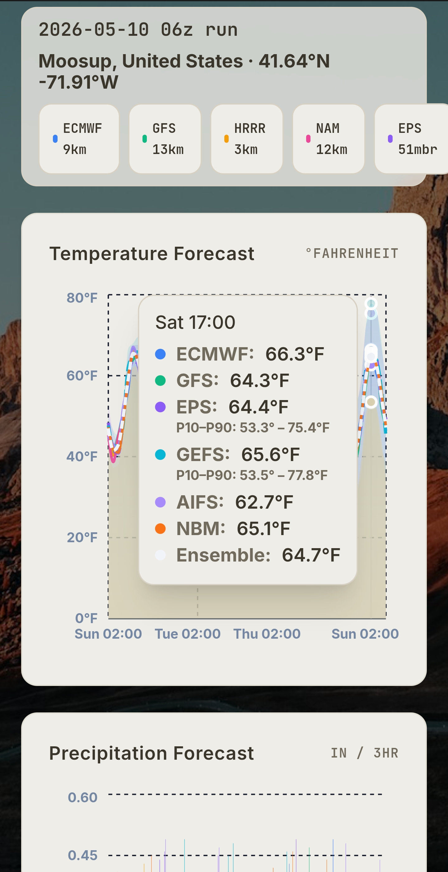
The NAM on Wednesday afternoon is interesting…… .
-
30-yr average at DCA is 10.65" for M-A-M. Lowest recently was 6.49" in 2023. 1986 is the modern times dud at 3.47". Most of the region is in the 4-7" range since March 1st, but DC to Annapolis and south are in worse shape. DCA is sitting at 3.72" and there are even spots in Calvert County and across the Bay that are ~2". There has not been a sub-6" Spring since 2006, so we are in rare territory if we don't get some substantial rain in the next 3 weeks.
- Today
-
Clouds look impressive to my west im sure the mountains will eat up most of the moisture
-
For NC piedmont and foothills it’s a matter of when not if we slip into exceptional drought. Long range looks dry and hot and obviously we missed most of the rain from last couple weeks.
-
Thursdays drought monitor will be interesting. I’d expect some marginal improvement along and south of I-85 but I’d say the foothills to the piedmont and southern VA are all about to be in an exceptional drought.
-

2026-2027 Strong/Super El Nino
jaxjagman replied to Stormchaserchuck1's topic in Weather Forecasting and Discussion
These westerlies the models have been showing has been countered with strong easterlies,so they have failed to get much past the IDL,maybe its gonna be different this time,probably could be the strongest ERW east of the IDL yet in this event
-

2026 Mid-Atlantic Severe Storm General Discussion
SnowenOutThere replied to Kmlwx's topic in Mid Atlantic
Thanks for the confirmation, I’m just spitballing in these threads after seeing the mesoanalysis page so it’s nice to hear I’m on the right track. Quick question but what is downdraft cape in relation to cape itself? Seems a bit like an oxymoron from the name itself. -
For the time being, and relative to date, the NH T mean has risen warmest comparing other curves in dataset for this product, https://climatereanalyzer.org/clim/t2_daily/?dm_id=nh
-
Multiple rumbles. Looks like we’re going to get 7-10’d.