All Activity
- Past hour
-
I’ve said it before, but I wish the O’s pitching was managed better.
-
Haven’t seen a more dismal (overall) background state for tropical activity since I was in middle school. MDR is the coldest it has been in years, subtropics are scorching, monstrous El Niño peaking intensity near late season.
-
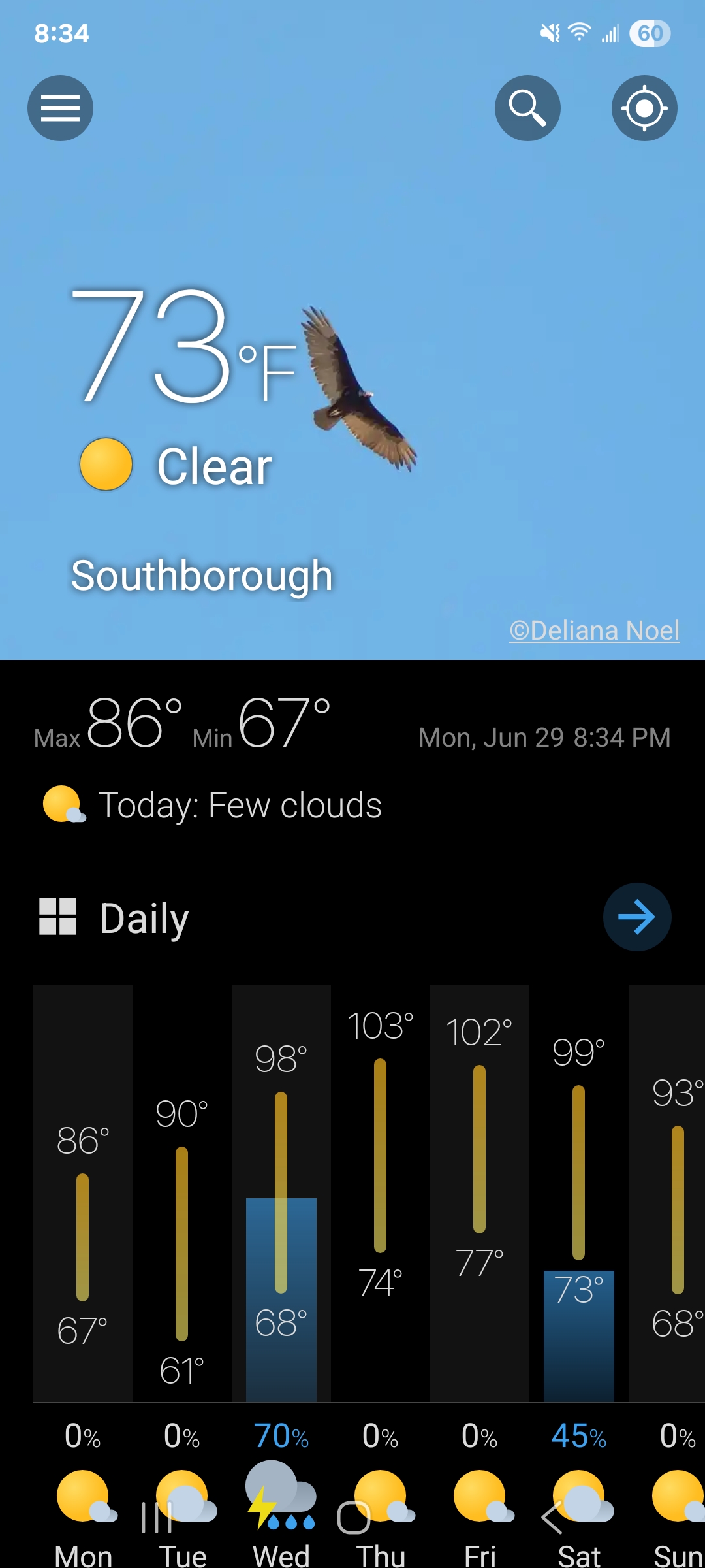
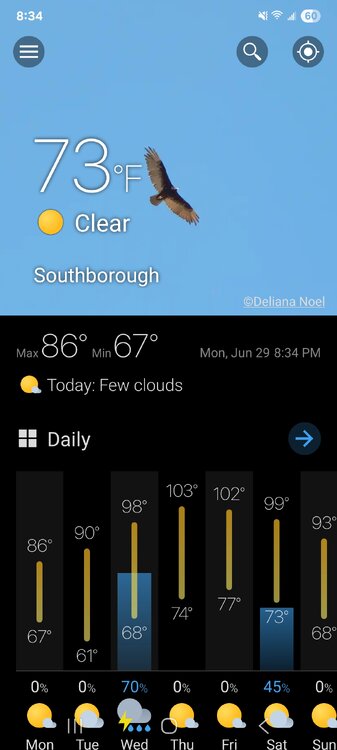
Can't wait to scour out the comfortable weather. 73° / 53° and clear blue skies.
-
Yes, there is a pithy saying "facts are meaningless without context!" This is why knowledge and understanding is history (wx or otherwise) is paramount, Things looks a lot different when you have this as part of your knowledge base. And I know this is cliche, but the longer you live, the more you see things better in this case. You realize that "this has happened before, and we did just fine overall, so it is really going to be that bad or are things that bad?" Don't get me wrong, there is impact and the negative, but what, do ppl really expect no impact or negative at all ever from wx? Geez, what planet are they living on? And you have to ask, how did we ever survive before the age of more advanced technology that makes us *far* safer and more resilient to wx?! This is the problem we face -- we have made great strides in improving things across the board for mitigating wx impacts, but you have this odd human tendency to just refocus on what bad or negative is left, and run w/ that, as if it way worse than before and the end is nigh.
-
The big question for us this week is when do the storms begin to reach our area. The Euro says Wednesday night, but other models say not til the weekend.
-
@SnowenOutThere Metrology is important(essential) to meteorology. Not sure that it is taught in a meteorology program(probably not), but imo it probably should be. If not, you can get a more profound understanding of some of the questions you seek by learning a bit more about it. Just a suggestion.
-
Speaking my language when we’re talking tropical
-

Central PA Summer 2026 Discussion/Obs Thread
canderson replied to Voyager's topic in Upstate New York/Pennsylvania
Hit 89 today. With NE winds. It’s going to absolutely roast here -

2026 Spring/Summer Mountain Thread
Maggie Valley Steve replied to Buckethead's topic in Southeastern States
83 for my high temp this afternoon and no rain here today. Congratulations Buckethead! -
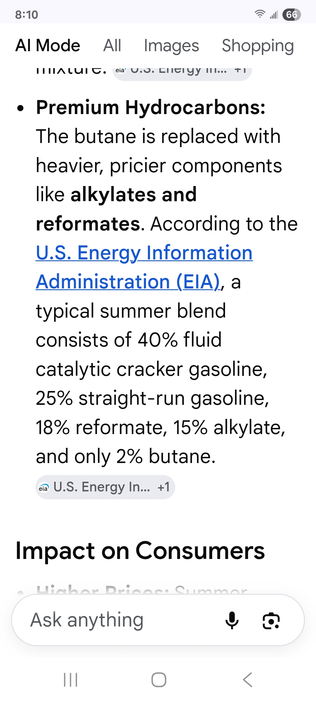
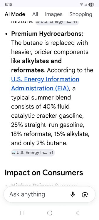
Actually I just looked it up. Ethanol percentage stays the same (rip off). The summer blend doesn't evaporate as fast. Apparently that's why it's more expensive.
-

Junorch obs and discussion 2026
CT Valley Snowman replied to Damage In Tolland's topic in New England
You might hit 96-97 if everything breaks right. -
I stand corrected. Thx! That makes the 1975 event even more insane. Since you had the all-time NE record temp of 107 set at EWB and 100s on Cape Cod, that still would suggest sig NW flow subsidence, and yet dews still that high? You wrote: "I just think that its kind of ironic how even with all this global warming that is happening, we still haven't been able to beat 1975" Ironic is an understatement. There is more to the story, as always the case when you have front and center heated debate/problem as to what is what. You could also say why something like the record heat/Dust Bowl of the 1930s has not occurred again, or why New England got 5 direct hurricane strikes from 1938 to 1960, and it has been almost 35 years since our last direct hurricane strike (all-time record gap). or why 31 of 50 U.S. states have recorded their all-time max temp from 1900-1937. There are numerous examples like the above all over the globe. How did such events in a cooler globe that match or exceed what has occurred in recent decades w/ the globe that much warmer? This is not rocket science or conjecture, it is basic logic. These past events are a matter of fact, and can't be discounted/ignored simply b/c it doesn't fit a narrative. What this proves is that the effects of a warmer globe are *not* linear and uniform. The MSM and alarmists act like *all* gets worse across the board everywhere b/c of warmer mean temps. That is an inane and vapid notion/mindset. The Earth's climate is a chaotic, non-linear, coupled system, yet you get too many treat is as 1-2-3. Example? Warmer ocean temps and that means bigger and more intense hurricanes. Yes, everything else being equal, that is true. What they conveniently ignore is changes to mean RH vertical depth in the tropics/subtropics, changes to vertical wind shear, and general circulation changes. Ocean temps are only one part of equation for hurricanes. Hurricanes, esp. intense ones, require very specific conditions, and everything has to line up properly. Throw one thing off (shear, moist environment, or SSTs), and that puts the breaks on this significantly. And I would argue that SSTs are the least important b/c you have more than warm enough SSTs in large areas across the globe to support intense TCs, or a TC at all, and how many occur per year? It is more of a delicate balance than one may think, and "more" (higher temps in this case) does not always work in a nice, neat linear fashion, esp. when it comes to complex systems.
-
DVN had 95 for us today. We hit 90.
-
A lot of crap does get thrown out there without context, and that definitely makes it hard to appropriately communicate when the true historic events happen. I think that for the most part it makes sense to use the written historical record, which obviously varies by location and quality control but is easiest to understand. I’ve personally communicated this coming heat wave in CT as “high end” or upper echelon if everything breaks toward overperforming, but critically, contextualizing what that means by showing the actual historical record for heat here. But I also lean in a lot more on heat index when talking about human impact.
-
Block heater
-
Today's Highs: New Brnswck: 92 PHL: 90 EWR: 89 TEB: 89 LGA: 88 NYC: 88 ACY: 87 ISP: 87 TTN: 87 BLM: 85 JFK: 84
-
Today's Highs: New Brnswck: 92 PHL: 90 EWR: 89 TEB: 89 LGA: 88 NYC: 88 ACY: 87 ISP: 87 TTN: 87 BLM: 85 JFK: 84
-
I probably need that up here in SLK. This winter obliterated my battery. That said, I like walking out in -20°…
-
I hit 90.3 in Huntington Station, which is consistent with a 91 just a few miles away in Commack.
-
I wish we could hit 100 here just to say we did it.. but not sure that's even possible
-
another quake video from the other day https://x.com/Breaking911/status/2071626498885206234
-
Yeah jesh this dry period has been something else. It looks like if you get underneath one of these storms at Buckethead mentioned you could have some strong cells with torrential rainfall and hail.
-
Junorch obs and discussion 2026
CT Valley Snowman replied to Damage In Tolland's topic in New England
My BOX p&c is 103 Thursday. I'm a bit skeptical, but man that would be sweet. - Yesterday
-
Hey I knocked the heated steering wheel, until my recent rig has it. I won’t lie, having an odd satisfaction leaving for the mountain and work at 4:45am and it’s -15F… but that steering wheel feels nice and warm lol. My wife always jokes I’ll go wander around Mount Mansfield in the brutal cold measuring snow and skiing, and then like a heated steering wheel. I do want the AC seats though, ha.
-
https://x.com/TylerSebreezy/status/2071380465630490940 The NSSL machine-learning severe probabilities show the classic "ring of fire" setup over the next 10+ days around our heat dome. The Northern Plains to the East Coast will have ingredients in place to support intense thunderstorm clusters/complexes and an MCS threat.