All Activity
- Past hour
-
Cue the Ralph Wiggum NAM GIF lol
-
2025-2026 Fall/Winter Mountain Thread
cold air aloft replied to Buckethead's topic in Southeastern States
I can tell you how this will play out where I am. It will be in the 20's with sleet/ZR in Buncombe County and rain with temps in the mid 40's IMBY with roaring SW winds a few hundred feet above me sounding like a 747. Having a warm nose take a way your winter storm is bad enough, but listening to it just adds to the misery lol. -

Pittsburgh/Western PA WINTER ‘25/‘26
Rd9108 replied to Burghblizz's topic in Upstate New York/Pennsylvania
Deep Mind
-
NAM heights are a little bit lower than 6z, and the Canadian HP is 1047 instead of 1045
-
NAM must run off a 1970 computer, it is so slow....
-

“Cory’s in LA! Let’s MECS!” Jan. 24-26 Disco
mahk_webstah replied to TheSnowman's topic in New England
Oh, I think you’re right. But I think it’s not just weenies who assume that the top range of a forecast is what will verify. The general public I think falls into that trap. -

Winter 2025-26 Short Range Discussion
Malacka11 replied to SchaumburgStormer's topic in Lakes/Ohio Valley
I feel like this is a cart before horse situation... Usually the CAD comes first but I wonder whether Alek might've gotten to these last two clippers or something -
1" here
-

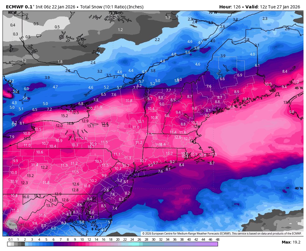
Possible Record Breaking Cold + Snow Sunday 1/25 - Tuesday 1/27
bluewave replied to TriPol's topic in New York City Metro
Good signal from the 6z Euro for at least a 6-8” floor around NYC and LI before any sleet arrives later Sunday using conservative 10-1 ratios which could be on the low side.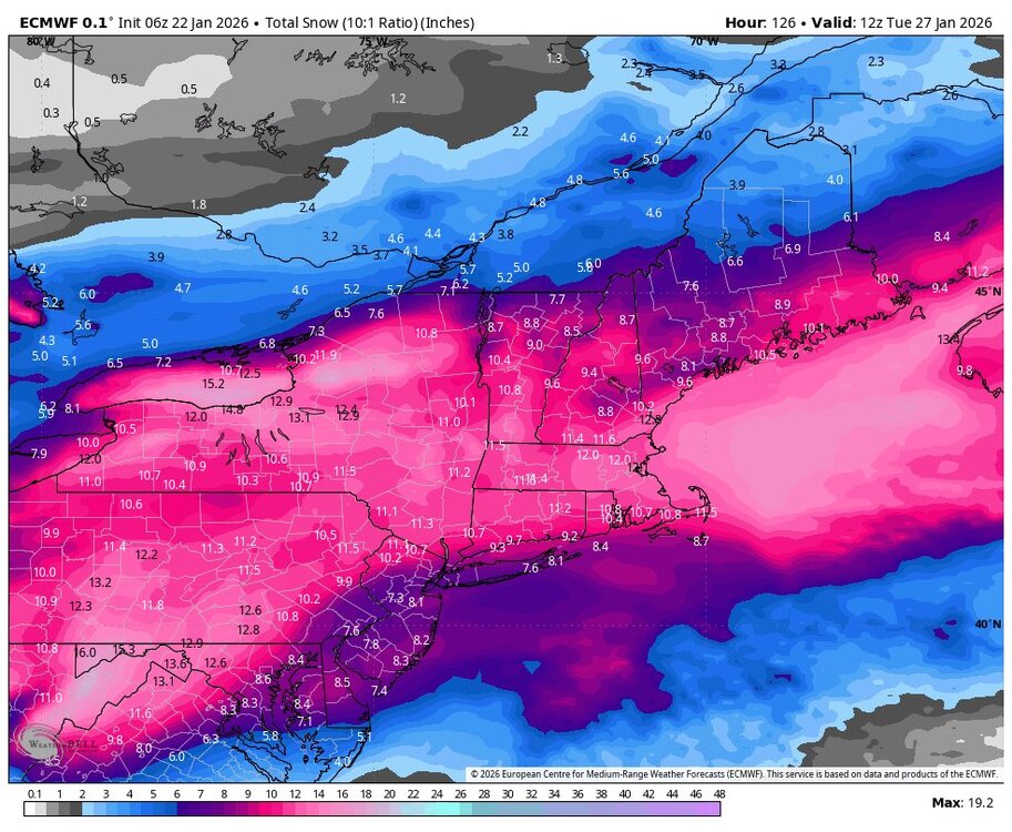
-

MO/KS/AR/OK 2025-2026 Winter Discussion
NWAflizzard replied to stormdragonwx's topic in Central/Western States
The 2-9 inch range in Paducah seems a little vague. -
It is really amazing how horrible the models are at forecasting winter storms 5 days out in 2026.
-
Winter better be over after next week.
-
12z NAM h5 48 06z NAM h5 54
-
I simply disagree. Weenies like it because they’re well weenies. If I had my forecaster hat on there is no way I would put that out over 3 days out. Maybe tomorrow I fine tune mesoscale jacks. Public or customers will see that and flip out. 10-18 would cover it for now.
-
Easier to clear every 6 hrs or so and keep a running tally until the end if its possible.
-
“Cory’s in LA! Let’s MECS!” Jan. 24-26 Disco
mahk_webstah replied to TheSnowman's topic in New England
Well, you know a lot more than I do lol. Maybe 10 to 20 would’ve been better. -

January 24-26: Miracle or Mirage JV/Banter Thread!
Scraff replied to SnowenOutThere's topic in Mid Atlantic
Me too, but I get to have beer along side it. Maybe late next week before the next HECS, we can have a happy hour / after work Sapwood meetup for those interested. -
Early changes on the NAM seem positive, let's see what it shows on the surface in a few frames.
-
Yeah I don’t see lollies to 24”.
-

January 25/26 Jimbo Back Surgery Storm
Thrasher Fan replied to Jimbo!'s topic in Southeastern States
Nice, dry weekend for most per the NAM. -
12z NAM h5 45
-
The phase looks like it will happen a bit later on this run. Both the northern and southern streams are hanging back a bit more.
-

“Cory’s in LA! Let’s MECS!” Jan. 24-26 Disco
Great Snow 1717 replied to TheSnowman's topic in New England
My 3rd string QB had to start the game... -

Texas 2026 Discussion/Observations
Stx_Thunder replied to Stx_Thunder's topic in Central/Western States
'Surprised to see SPC already mentioning the wintry thunder/convective potential in their current D3 outlook this morning. Which will only jump up the icing accumulation in ETX where it'd be most likely. -
Great post! Can see that 50/50 is trying to work it's magic here. Any amount helps to lock things in.