
cold air aloft
-
Posts
143 -
Joined
-
Last visited
About cold air aloft

-
2025-2026 Fall/Winter Mountain Thread
cold air aloft replied to Buckethead's topic in Southeastern States
Jack Daniel’s Single Barrel -
2025-2026 Fall/Winter Mountain Thread
cold air aloft replied to Buckethead's topic in Southeastern States
Light rain/sleet and 42 degrees in my area. -
2025-2026 Fall/Winter Mountain Thread
cold air aloft replied to Buckethead's topic in Southeastern States
How awesome is this y’all! We were long overdue for an event like this. Heavy snow, no friggin warm nose to worry about and it’s not going anywhere anytime soon. Enjoy everyone! -
2025-2026 Fall/Winter Mountain Thread
cold air aloft replied to Buckethead's topic in Southeastern States
-
2025-2026 Fall/Winter Mountain Thread
cold air aloft replied to Buckethead's topic in Southeastern States
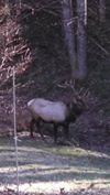
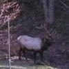
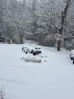
A cold ground makes all of the difference. Everything that is falling is sticking. My yard is solid white. -
2025-2026 Fall/Winter Mountain Thread
cold air aloft replied to Buckethead's topic in Southeastern States
Light flurries in Maggie. -
2025-2026 Fall/Winter Mountain Thread
cold air aloft replied to Buckethead's topic in Southeastern States
I really hope this is a Murphy to Manteo event., it would be great to see everyone cash in. -
2025-2026 Fall/Winter Mountain Thread
cold air aloft replied to Buckethead's topic in Southeastern States
I saw that post as well and while I respect that meteorologist, I thought that might just be a bit premature. -
2025-2026 Fall/Winter Mountain Thread
cold air aloft replied to Buckethead's topic in Southeastern States
20 degrees with a nice dusting of snow. Still flurrying a little. -
2025-2026 Fall/Winter Mountain Thread
cold air aloft replied to Buckethead's topic in Southeastern States
It’s going to be a skating rink tomorrow morning when all of this precip freezes with the crashing temperatures. -
2025-2026 Fall/Winter Mountain Thread
cold air aloft replied to Buckethead's topic in Southeastern States
44 and rain with a robust wind from the south. Don’t know exactly how much ice I got before the warm up, but that’s the most ice accretion I’ve ever seen here in Maggie. Like Met mentioned, this is still an ongoing event for many in Haywood County. One for the record books for sure. -
2025-2026 Fall/Winter Mountain Thread
cold air aloft replied to Buckethead's topic in Southeastern States
I really feel like this is going to be a historic event for those of us in the TN border Counties. -
2025-2026 Fall/Winter Mountain Thread
cold air aloft replied to Buckethead's topic in Southeastern States
I was skeptical of GSP’s Ice forecast for Haywood County based on my life experience here, but they are on target. -
2025-2026 Fall/Winter Mountain Thread
cold air aloft replied to Buckethead's topic in Southeastern States
The rain is picking up and my truck already has a nice glaze on it. -
2025-2026 Fall/Winter Mountain Thread
cold air aloft replied to Buckethead's topic in Southeastern States
29 and light ZR with a brisk NE wind.

