cold air aloft
-
Posts
143 -
Joined
-
Last visited
Content Type
Profiles
Blogs
Forums
American Weather
Media Demo
Store
Gallery
Everything posted by cold air aloft
-

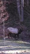
2025-2026 Fall/Winter Mountain Thread
cold air aloft replied to Buckethead's topic in Southeastern States
Jack Daniel’s Single Barrel -
2025-2026 Fall/Winter Mountain Thread
cold air aloft replied to Buckethead's topic in Southeastern States
Light rain/sleet and 42 degrees in my area. -
2025-2026 Fall/Winter Mountain Thread
cold air aloft replied to Buckethead's topic in Southeastern States
How awesome is this y’all! We were long overdue for an event like this. Heavy snow, no friggin warm nose to worry about and it’s not going anywhere anytime soon. Enjoy everyone! -
2025-2026 Fall/Winter Mountain Thread
cold air aloft replied to Buckethead's topic in Southeastern States
-
2025-2026 Fall/Winter Mountain Thread
cold air aloft replied to Buckethead's topic in Southeastern States
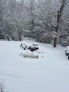
A cold ground makes all of the difference. Everything that is falling is sticking. My yard is solid white. -
2025-2026 Fall/Winter Mountain Thread
cold air aloft replied to Buckethead's topic in Southeastern States
Light flurries in Maggie. -
2025-2026 Fall/Winter Mountain Thread
cold air aloft replied to Buckethead's topic in Southeastern States
I really hope this is a Murphy to Manteo event., it would be great to see everyone cash in. -
2025-2026 Fall/Winter Mountain Thread
cold air aloft replied to Buckethead's topic in Southeastern States
I saw that post as well and while I respect that meteorologist, I thought that might just be a bit premature. -
2025-2026 Fall/Winter Mountain Thread
cold air aloft replied to Buckethead's topic in Southeastern States
20 degrees with a nice dusting of snow. Still flurrying a little. -
2025-2026 Fall/Winter Mountain Thread
cold air aloft replied to Buckethead's topic in Southeastern States
It’s going to be a skating rink tomorrow morning when all of this precip freezes with the crashing temperatures. -
2025-2026 Fall/Winter Mountain Thread
cold air aloft replied to Buckethead's topic in Southeastern States
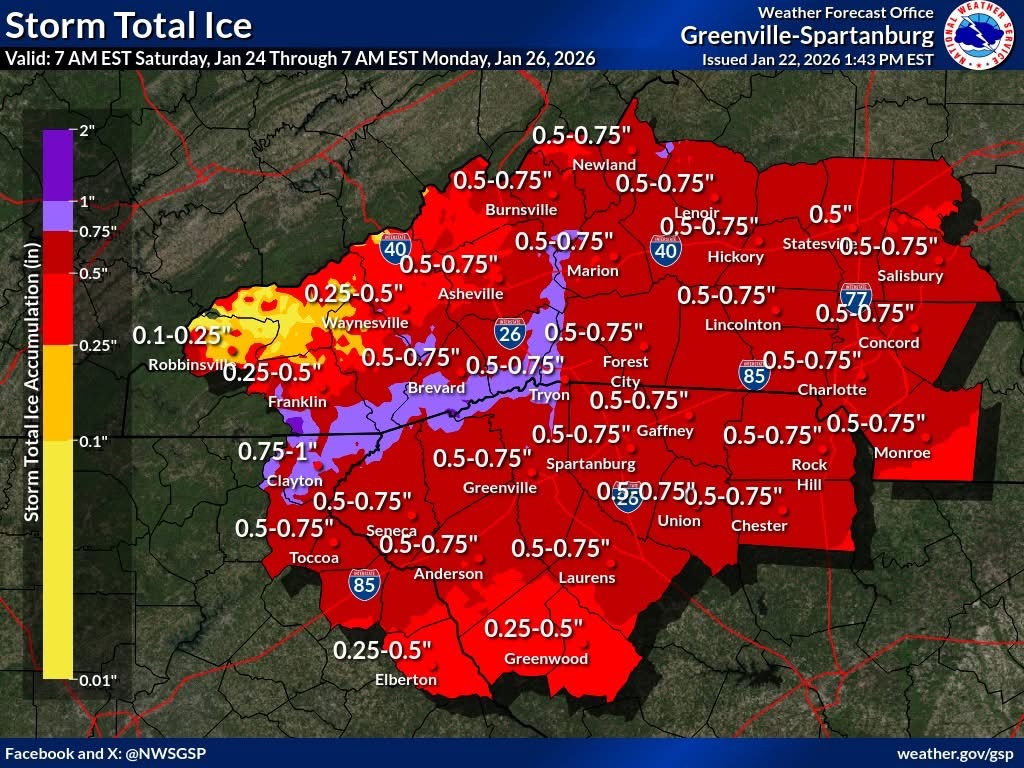
44 and rain with a robust wind from the south. Don’t know exactly how much ice I got before the warm up, but that’s the most ice accretion I’ve ever seen here in Maggie. Like Met mentioned, this is still an ongoing event for many in Haywood County. One for the record books for sure. -
2025-2026 Fall/Winter Mountain Thread
cold air aloft replied to Buckethead's topic in Southeastern States
I really feel like this is going to be a historic event for those of us in the TN border Counties. -
2025-2026 Fall/Winter Mountain Thread
cold air aloft replied to Buckethead's topic in Southeastern States
I was skeptical of GSP’s Ice forecast for Haywood County based on my life experience here, but they are on target. -
2025-2026 Fall/Winter Mountain Thread
cold air aloft replied to Buckethead's topic in Southeastern States
The rain is picking up and my truck already has a nice glaze on it. -
2025-2026 Fall/Winter Mountain Thread
cold air aloft replied to Buckethead's topic in Southeastern States
29 and light ZR with a brisk NE wind. -
2025-2026 Fall/Winter Mountain Thread
cold air aloft replied to Buckethead's topic in Southeastern States
34 with a few sleet pellets in my part of Maggie Valley. -
January 25/26 Jimbo Back Surgery Storm
cold air aloft replied to Jimbo!'s topic in Southeastern States
I think it’s like analytics in sports, we have all of this new technology to rely on that some people forget that life experiences and common sense are still worth something. There is still a place for the cagey, veteran baseball manager who will use analytics to a point, but still rely on his gut when to make a pitching change. Same with weather forecasters, models and data are wonderful tools, but you also need to rely on knowing how basic climatology works in your backyard. Just my two cents. -
2025-2026 Fall/Winter Mountain Thread
cold air aloft replied to Buckethead's topic in Southeastern States
Met and Steve, when is the last time y’all remember Haywood County having a major ice event, especially up through the Balsams? In my recollection it’s been maybe 20 years or more. A very rare occurrence around these parts if that verified.
-
2025-2026 Fall/Winter Mountain Thread
cold air aloft replied to Buckethead's topic in Southeastern States
I can tell you how this will play out where I am. It will be in the 20's with sleet/ZR in Buncombe County and rain with temps in the mid 40's IMBY with roaring SW winds a few hundred feet above me sounding like a 747. Having a warm nose take a way your winter storm is bad enough, but listening to it just adds to the misery lol. -
2025-2026 Fall/Winter Mountain Thread
cold air aloft replied to Buckethead's topic in Southeastern States
Less than 72 hours before the event, I honestly don't think I will be surprised whatever the outcome is. A few days ago I was thinking all snow above I-85 and while that doesn't look likely now, it still wouldn't totally shock me. I believe the next 48 hours in the modeling are going to offer up a few surprises. What a strange setup all of this is. Might as well enjoy the ride y'all! I -
2025-2026 Fall/Winter Mountain Thread
cold air aloft replied to Buckethead's topic in Southeastern States
I still think this turns out to mostly a snow event from I-85 north. -
2025-2026 Fall/Winter Mountain Thread
cold air aloft replied to Buckethead's topic in Southeastern States
Hunter mentioned watching the radar returns develop today in Louisiana. The returns there and in East Texas are starting to look pretty interesting to me. -
2025 Spring/Summer Mountain Thread
cold air aloft replied to Maggie Valley Steve's topic in Southeastern States
It's been wild this week, all of these storms just keep going around Maggie. -
2025 Spring/Summer Mountain Thread
cold air aloft replied to Maggie Valley Steve's topic in Southeastern States
That’s March weather here in the mountains for you, something for everybody. -
2025 Spring/Summer Mountain Thread
cold air aloft replied to Maggie Valley Steve's topic in Southeastern States
I’m afraid so too. What is going on in Mississippi right now is just devastating. It’s going to be a rough time for many in the SE now though tomorrow unfortunately.