All Activity
- Past hour
-

January 2026 regional war/obs/disco thread
Torch Tiger replied to Baroclinic Zone's topic in New England
attacking in DM's is not adult-like -
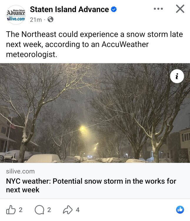
This is from Jan 6-7th last year. Had snow otg for weeks, then a bit more snow and another big snow storm in Feb. Maybe a little later this year, but lets hope for similar outcomes.
-

January 2026 regional war/obs/disco thread
Snowcrazed71 replied to Baroclinic Zone's topic in New England
It seemed to have gone by the wayside with the drama that seems to happen on this form often. Lol. But I did hear through a birdie that they're looking pretty good. And I don't think it's just one particular model either -

January 2026 regional war/obs/disco thread
ORH_wxman replied to Baroclinic Zone's topic in New England
Yeah, it is unfair to grade someone's forecasting ability if they aren't actually issuing forecasts on here. Talking about the pattern isn't issuing a forecast. You can disagree with their pattern analysis, but it's not fair to call it a forecast if they were just analyzing an ensemble run or a model run. Some mets and plenty of amateurs do issue forecasts from time to time, and those are fair game to critique as well. But I think people should be clear about what they are critiquing. Model analysis is not the same as an actual forecast. And I also don't think it is an indictment on anyone's skill if they post more or less depending on what type of sensible wx the models are showing. I'm sure most mets on here have a lower post rate when we have a vortex over AK and a zonal mild flow in mid-winter. I know I do. I could keep posting about whether the zonal flow might change enough to give us high temps of 54F instead of 47F, but that is about as interesting to me as watching paint dry, so I normally refrain. There are others on here to pick up the slack on that type of discussion if I don't want to do it. Additionally, I think "pattern talk" is much more likely to occur during periods where there are no imminent threats. We're searching for the next "interesting period". We all know that in rapid-fire stretches of winter storms, we are not constantly posting much about longwave patterns or what some vague D11-15 signal might produce....we're dissecting smaller scale features over a short term storm threat, and maybe tracking another one in the medium range. All of the oxygen gets sucked up during those times with the threats themselves and not pattern talk. -

Occasional Thoughts on Climate Change
TheClimateChanger replied to donsutherland1's topic in Climate Change
Here's another example of a pairing. This subforum spends a disproportionate amount of time discussing Chester County, PA. So I decided to locate a pair for the small town of Avondale, Pennsylvania. And if you look at the data, it's very similar to Warrenton, Va. of the late 20th century, over the past 10 years. And these two sites are acceptable pairs because they are both small towns on the edge of large metro areas, at similar elevation, and in a similar location relative to the coast. -
[emoji817]
-

January 2026 regional war/obs/disco thread
WxWatcher007 replied to Baroclinic Zone's topic in New England
Did anybody see the 12z…oh… -
You can really feel it warm up with that extra hour of daylight
-
I grabbed a couple of these from CPC...the MA forum has also posted these.
-
It has been off the table for us for a couple of days now. The warm front is going to stay south of us, so the 60s and 70s will make it into southern VA and part of the lower Eastern Shore, but we'll be stuck in the 40s, maybe getting to the low 50s Saturday evening with a little mixing. The good news is that the further south position of the warm front puts us in a good position for significant rain.
-

Winter 2025-26 Short Range Discussion
SchaumburgStormer replied to SchaumburgStormer's topic in Lakes/Ohio Valley
Bears packers, in a snow squall. Epic setup incoming -

January 2026 regional war/obs/disco thread
KoalaBeer replied to Baroclinic Zone's topic in New England
And this is why we can’t have nice things… When the actual Mets with a degree stop posting as much and we wonder why, the past few pages are the answer. I may not post much but the reason I lurk often is because of the insights you get here from actual meteorologists that they otherwise aren’t going to share on official NWS products etc. If you want a cookie cutter risk adverse discussion go read your local AFD twice a day dink. So a special thank you to posters such as Brooklyn, Coastal, Chris, Wiz, Seymour and Tip (even though I don’t know what you are saying 50% of the time, something about the flow being raging fast!) Your insights are much appreciated from me. -

January 2026 regional war/obs/disco thread
Kitz Craver replied to Baroclinic Zone's topic in New England
Yeah man, 100%. Don’t be dissing Brooklyn. I personally love his contributions to the forum. I didn’t see the comment, but F whatever it said. -
Occasional Thoughts on Climate Change
TheClimateChanger replied to donsutherland1's topic in Climate Change
Obviously, you want to find pairs that aren't drastically different in elevation. I would not agree that "many areas it gets hotter as you go north in the summer" - that may be the case for the Florida peninsula, but mean summertime temperature changes are still largely consistent with latitudinal changes for the bulk of the continental US, even if the gradient is somewhat reduced. Again, obviously, excluding higher elevated locations to the south where the elevation induces cooling. -
I missed the squall as I was out of town, so I’m in for this one.
-
An orderly pattern progression remains underway. In the extended range, that progression should culminate in a return to colder weather with persistently below normal temperatures. A storm heading through the Great Lakes will bring rain tomorrow into early Sunday. A general 0.50"-1.00" rainfall appears likely across much of the region. Through the middle of next week, highs will generally reach the 40s during the daytime and 30s for lows in New York City. Somewhat colder readings are likely outside the City and in areas where strong radiational cooling takes place. After the middle of next week, temperatures will "step down" with highs mainly in the middle and upper 30s in New York City and lows in the middle and upper 20s. No significant Arctic blasts or significant snowfalls are likely through at least mid-January. Afterward, conditions might become more favorable for both cold and snowfall, especially if the PNA goes positive. PNA-related developments would have larger implications for snowfall. A persistently positive PNA would have above climatological risk of moderate or significant snowfalls. A mainly negative PNA would favor mainly small snowfalls. It will likely be a few more days before the guidance reaches the high-skill timeframe for teleconnection forecasts. The ENSO Region 1+2 anomaly was -0.7°C and the Region 3.4 anomaly was -0.5°C for the week centered around December 31. For the past six weeks, the ENSO Region 1+2 anomaly has averaged -0.37°C and the ENSO Region 3.4 anomaly has averaged -0.63°C. La Niña conditions will likely continue into at least late winter. The SOI was +4.62 today. The preliminary Arctic Oscillation (AO) was -1.466 today. Based on sensitivity analysis applied to the latest guidance, there is an implied near 55% probability that New York City will have a cooler than normal January (1991-2020 normal). January will likely finish with a mean temperature near 33.4° (-0.3° below normal). Supplemental Information: The projected mean would be 0.8° above the 1981-2010 normal monthly value.
-
Yeah tonight's rainfall is going to put a dent to this dry spell.
-

Occasional Thoughts on Climate Change
WolfStock1 replied to donsutherland1's topic in Climate Change
From the way you describe it seems like your premise is that the climate (temperature in this case) is just a straight north-south gradient (?) and without seasonality. There are lots of places of course where the climate gets colder as you go south (e.g. into mountains); also it depends on the season - in many areas it gets hotter as you go north in the summer, but colder when you follow the same path in the winter. This is typical for instance as you move away from oceanside areas. E.g. Tampa's average peak high is 91 degrees, but if you go north to Tallahassee the average peak high is 93 degrees. But Tallahassee gets a lot colder than Tampa in the winter. So when shifting via warming the climate analog not only shifts around from season to season, but could even flip north/south depending on the location. That said - you could certain find some "pairs" of similar locations to do what you said. It just wouldn't work for a lot of locations. -
8 weeks until we move the clocks ahead
-
Snow is more important than all of those things. What kind of weenie are you?.
-

Mid-Long Range Discussion 2026
WinstonSalemArlington replied to BooneWX's topic in Southeastern States
The times, they are a changin’ -

2025-2026 Fall/Winter Mountain Thread
Maggie Valley Steve replied to Buckethead's topic in Southeastern States
It probably about that time when we start seeing some crazy computer runs for next week and just beyond. We're getting some very beneficial rain today. Possibly some thunder tonight and tomorrow as well. Perhaps that old rule plays out this time! -
January 2026 regional war/obs/disco thread
Snowcrazed71 replied to Baroclinic Zone's topic in New England
We're grown adults here. Not children. And it's called couth, something that you should try working on. There is a way of saying things to someone without saying it in such a rude manner. Anyway, being real and direct doesn't make you respectable.... ( and for the record, most of us are well aware that most of his posts are ultra positive and that most of them don't actually come to fruition, but ... he's never said in any of his posts that that they were going to happen ). He would just post what could happen with the best case scenario. There's a big difference there. -
One day (Nov. 26) prevented us from ending the year with 5 consecutive months that had below normal temps. Thanks alot November 26th....
-