All Activity
- Past hour
-

2025 Short Range Severe Weather Discussion
pen_artist replied to Chicago Storm's topic in Lakes/Ohio Valley
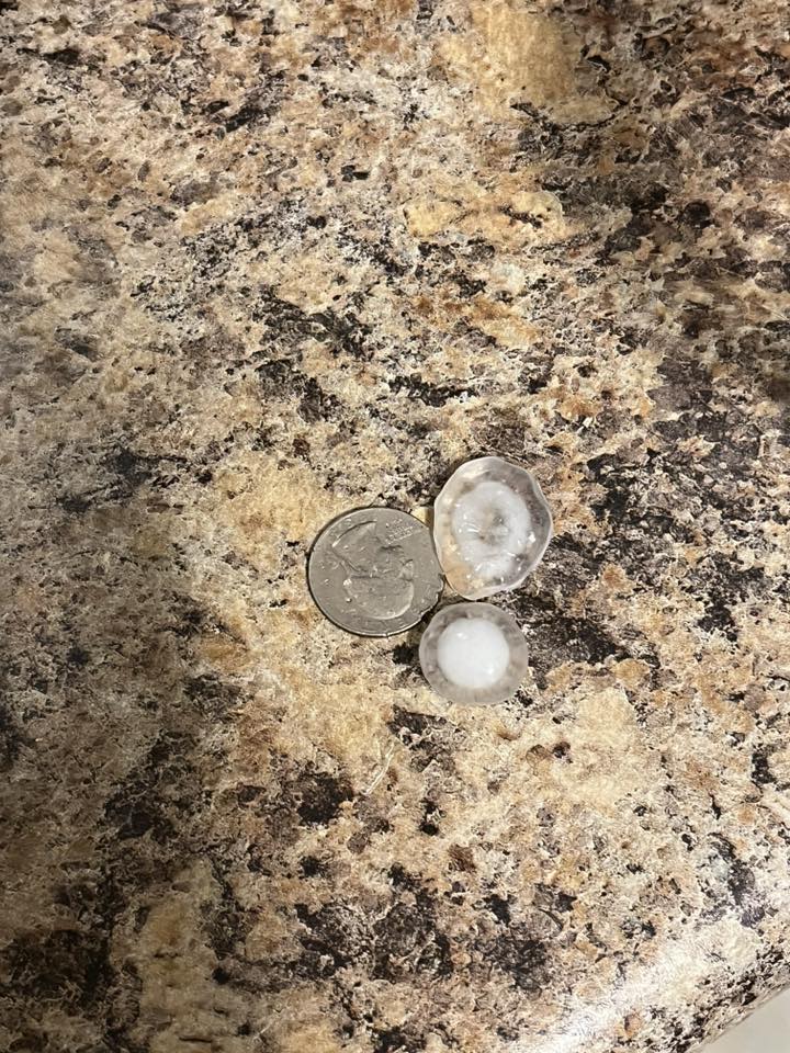
Got some quarter hail and strong winds, not sure of what the wind damage looks like though in Downers Grove/Woodridge area.
-
The weather was kinda weird today. Quite a few showers on the northwest side of the Catoctin’s, but they fizzled on approach. Ended up with a few rounds of light rain, but that was about it.
-
18z Euro came back east a bit but not by much..
-

NEW DISTURBANCE: Central Tropical Atlantic (0/20)
BarryStantonGBP replied to BarryStantonGBP's topic in Tropical Headquarters
Tropical Weather Outlook NWS National Hurricane Center Miami FL 800 PM EDT Sat Aug 16 2025 For the North Atlantic...Caribbean Sea and the Gulf of America: Active Systems: The National Hurricane Center is issuing advisories on Hurricane Erin, located about 100 miles north of the Virgin Islands. 2. Central Tropical Atlantic: An area of low pressure could form over the central tropical Atlantic during the middle to latter portion of next week from a westward moving tropical wave. Some subsequent development could occur as the system moves westward to west-northwestward at around 15 mph. * Formation chance through 48 hours...low...near 0 percent. * Formation chance through 7 days...low...20 percent. Forecaster Patel -
Erin is going to be strong and stacked vertically. it will feel the tug, and we have a forcefield up here.
-
OI OIII NEW DISTURBANCE LADZZZZ
-
I'm more worried about the next. Short term forecast for ERIN isn't even close to being accurate. If this was my profession, I'd be very careful declaring A FISH. The thrill (skill) is why and how? This we all know but the timing is off. My memory is terrible, years and named storms. I recall a tropical entity that miss (3) troughs, looped a couple of times just off NC.
-
How much do you have for the summer?
-
Coming up on the 35th anniversary here in less than two weeks. 60mph gust from the outflow of a cell that clipped to the north, rainless, then picked up a quick 8/10” as it filled in. Second cell incoming now, also pretty gusty.
-

Hurricane Erin: 160 MPH - 915mb - W @ 16
Kevin Reilly replied to BarryStantonGBP's topic in Tropical Headquarters
And they eye fills in and disappears when doing so looks like Erin starts getting shoved WSW a bit definitely going through a cycle now. I wonder what track implications this may have down the road we shall see. -
CVs are pretty but they’re the 10 at the party that’s too good for everyone.
-

Hurricane Erin: 160 MPH - 915mb - W @ 16
hawkeye_wx replied to BarryStantonGBP's topic in Tropical Headquarters
The pressure has risen all the way up to 930 mb. -
This could “possibly” be like that deal we had in I think 2001. We had a strong offshore cane and strong HP to north and it created huge pressure gradient . There were HWW for all of SNE. I remember it distinctly. Was sunny/ cirrus but winds ripped during the day . I may not have year right, but I’ve talked about that event in here before
-
What a waste
-
Best fish storm evah!
-
Hmm… No rain, but the wind field is massive on all guidance. Significant hit for Newfoundland too.
-
 Say no more.
 -
Correct. Not worried about their immediate safety, but the ferrys may stop running for 2-3 days and that alone causes some big issues out there.
-

Hurricane Erin: 160 MPH - 915mb - W @ 16
DDweatherman replied to BarryStantonGBP's topic in Tropical Headquarters
I’m just razzing you hahaha. I’m excited for tracking though. This is a good appetizer. -
I’d say direct impacts are still unlikely but if EURO is correct it wouldn’t surprise me to see tropical storm advisories hoisted and given the expected size and wind field of the storm wave run up and over wash are almost a guaranteed issue at this point. I was there last week with the full moon and nor Easter and there wasn’t any beach at all
-
0.0” from that. he is here he is there he is everywhere.
-

Hurricane Erin: 160 MPH - 915mb - W @ 16
marsman replied to BarryStantonGBP's topic in Tropical Headquarters
50+ mph gusts in northern BVI. -
Absolutely frog strangling storm out there currently. It was so humid, I figured something had to give at some point.
-
Nice shots. There’s nothing like weather advancing over water.
-
"Meanwhile, dewpoints start off the week in the 40s and 50s meaning no high humidity to speak of, though dewpoints may creep up into the 60s briefly on Wednesday before drier air is once again pulled in behind the exiting tropical system"