All Activity
- Past hour
-

January 2026 regional war/obs/disco thread
Typhoon Tip replied to Baroclinic Zone's topic in New England
That had a pretty steep gradient to it. I was in Acton and we managed 15". Boston was around 18 but up at UML in Lowell it was 10" I think if memory serves. But it was 2 foot or so in Hartford. I don't think S Vt saw much at all -
Looks like no advisory from Upton Wind gusts likely continue to remain in the 30-40mph range tonight with strong CAA allowing substantial BL mixing even overnight. Used 90th percentile of the NBM and winds were still below Wind Advisory criteria, so did not issue a Wind Advisory. Peak gusts during this period may touch advisory levels, but right now, it looks isolated.
-
 Weatheriscool changed their profile photo
 -

December 2025 regional war/obs/disco thread
Great Snow 1717 replied to Torch Tiger's topic in New England
In Rainthuen nothing says deep winter like a cold rain and fog... -
DTW peaked at 61F at 9pm. Temp fell from 59F at midnight to 23F at 8am. Wind chills are currently around 0F with snow squalls approaching.
-
Nice! Im staying in Newberry Feb 18-21 but will be going to different areas.
-
Thanks! We actually are on the second floor. If i can't jump off the second story when I leave on Saturday it's a bust lol. Wind starting to pick up. Warm here in the lowlands as I pack my truck for the voyage to the great north woods.
-

Winter cancelled/uncancelled banter 25/26
Stormlover74 replied to Rjay's topic in New York City Metro
Probably the same poster who canceled winter a week ago -
Looks decent for some light snow accumulations in New England on New Years day but those usually don't pan out well for us down here. FROPA is usually all dried out for us
-
Things should kick off quickly by mid-afternoon as a band of lake-enhanced snow squalls along a sharp trough pushes off the lake. Thereafter, inversion heights and moisture depth do become marginal pretty quickly but the airmass will support good snow growth even in shallow LES bands, and upstream radars still look solid...so, there's optimism for a window of continued WNW flow LES into a good portion of tonight behind the squalls along the trough axis this afternoon.
-
That's what I'm talkin about people. Dude knocked off almost 6 degrees in 2 hours. We can do it, too. It's happening. Let's do this.
-

January 2026 regional war/obs/disco thread
Damage In Tolland replied to Baroclinic Zone's topic in New England
Looks like a period of steady light snow. Some places will get an inch or two . But most should at least whiten things up -

2025-2026 Fall/Winter Mountain Thread
Buckethead replied to Buckethead's topic in Southeastern States
27 with moderate snow in Wolf. Sent from my Pixel 10 Pro using Tapatalk -
Wasn’t their someone here saying that all it ever does is rain on New Year’s Eve? Hmmm
-
Hate wind. Gross. Good luck to the Tug Hill chasers. Don't think my car could make that journey lol. Hope your cabin has a second floor exit
-
Wind is starting to kick up here
-
whereabouts in brooklyn
-

Winter cancelled/uncancelled banter 25/26
North and West replied to Rjay's topic in New York City Metro
. -

January 2026 regional war/obs/disco thread
Baroclinic Zone replied to Baroclinic Zone's topic in New England
Decent s/w but orientation is not so great for much amplification as the flow is pretty compressed. Amplification occurs offshore. It’s moisture starved to begin with. I would not expect much at this point other than some flurries. My hoped is downstream ULL can migrate back westward some to allow heights to build ahead. Big ask at this point. -

January 2026 regional war/obs/disco thread
40/70 Benchmark replied to Baroclinic Zone's topic in New England
Actually, looks like Haverhill had 16"...I would still classify that as "lesser" for my area.... -
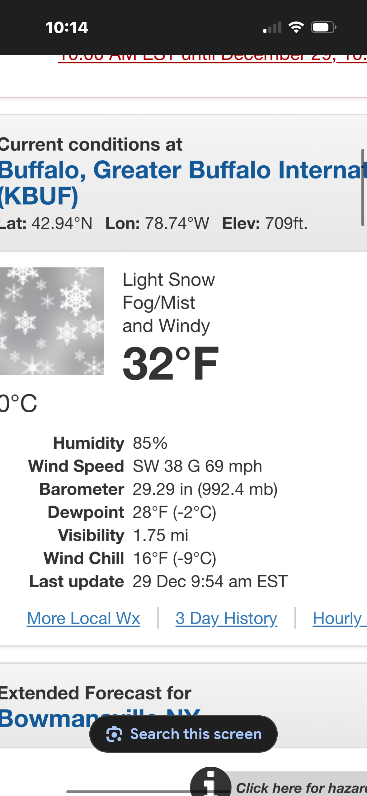
Down to 44.3/37.0 at 10 am, winds WNW at 14 gusting 31 mph.
-
December 2025 regional war/obs/disco thread
Damage In Tolland replied to Torch Tiger's topic in New England

-
Some kind of weird restriction here on AmericanWX seems they give each user so much storage and it's not a lot at all. Believe most on here embed@Carvers Gap@Holston_River_Rambler among others can probably point you in the write direction. Congratulations on the new addition btw
-

Mid-Long Range Discussion 2026
WinstonSalemArlington replied to BooneWX's topic in Southeastern States
-
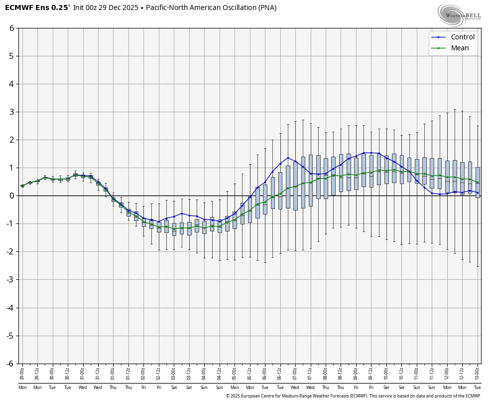
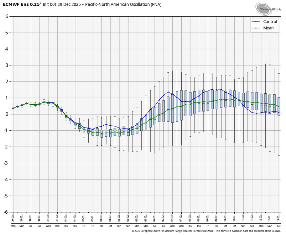
Thanks for your reply. I agree it is a risk, unfortunately. But my supported hopes (GEFS 2nd week on avg has been awful and much too warm) are that today’s 0Z EPS’ moderate +PNA, which starts Jan 7th, will prevail: Today’s 12Z ens runs will be extra interesting due to this major disagreement in week 2!
-
January 2026 regional war/obs/disco thread
40/70 Benchmark replied to Baroclinic Zone's topic in New England
Not for my area....like 7" of sand.