All Activity
- Past hour
-
I was just doing my LibertyBell impression
-

Central PA Spring 2025
Itstrainingtime replied to canderson's topic in Upstate New York/Pennsylvania
Sun is out brightly here just to your southeast. -
Given the PDO is erratic, their study may be valid. Who knows if the Atlantic will ever cool off? Scientific consensus across all Journals is evolving. Or, we lack understanding to model the causation. Either way, the historical record may be useful. What's North American 2m temperature do with different states of the Atlantic and Pacific (and combos)? Instead of treating them as predictable oscillators, just take the Ocean temps at face value during this or the upcoming season. Both negative is going to be a cold possibly snowy winter for many. Both positive is going to be grill out and drink for many. If I was going to pick on oscillator to quit, I'd punt the QBO. It's rate of change could be useful, but its steady state has not been useful since George Bush was president.
-
The afternoon after 1:30 is jacked dicked. No doubt . It’s coming East to wet campsites all along the E MA coast
-
Wow what a day. Congrats.
-
Would’ve been a disaster but fun in winter. Both my station and HFD recorded a low of 982.0mb. Very impressive for this time of year.
-
Someone got a video of Canderson setting up a pool in his backyard... https://www.facebook.com/share/v/1ABoYjj8Ar/
-
Heavy rain and gusty winds Birds in dogwood caught off guard and are on porch
-

Central PA Spring 2025
Mount Joy Snowman replied to canderson's topic in Upstate New York/Pennsylvania
We have the kids up at my parent’s house in Etown and a nice soaker is rolling through right now. -
-
Plenty of reactions on social media to my Ghost Data post...
-
Incredible looking radar of system shaped like an italicized 9
-
Exactly as predicted.
-
you'll get 'em next time
-
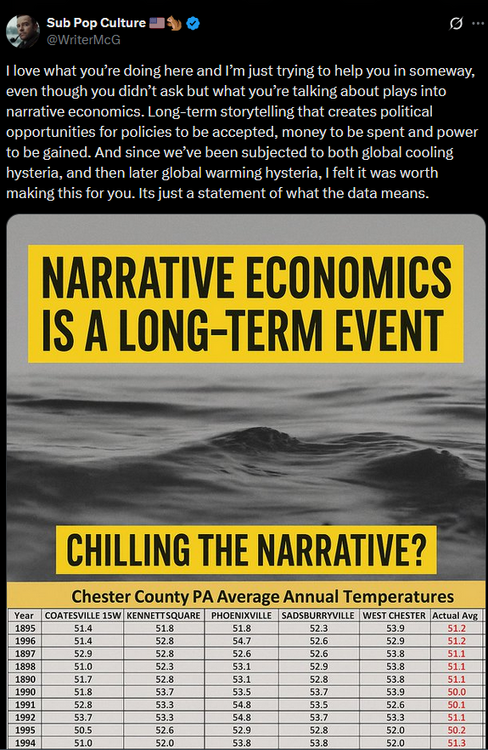
 @chubbssays "We have reviewed the raw data from those 3 stations over and over again. Coatesville and West Chester moved from towns to less built up locations and cooled by 2F. While Phoenixville ran much warmer than surrounding stations in the 1930s, 1940s and 1950s due to higher afternoon temperatures and time of day bias" You never answer the question if Coatesville and West Chester cooled with moves....why did NCEI cool those stations and the county to levels below any of those 3 raw station data?
 -
12z/31 Guidance including ensembles continues 80s inland Tue-Fri, possibly weekend, with 90 possible Thu-Fri...even NYC??? AC will be needed parts of the inland areas Thu-Fri afternoon. So far, below June heat advisory guidance (I think still lower threshold in May-June than JAS) this coming Thu-Fri.
-
This winter is gonna be rockin'!
-
Many thanks. The problem is that I don't remember to whom I've told which story - 2,3,4 times.
-
Davis seems top of the line for us enthusiasts
-
-

2025 Lawns & Gardens Thread. Making Lawns Great Again
DavisStraight replied to Damage In Tolland's topic in New England
Not sure, I've also used poison ivy killer, it keeps coming back. It's usually on a 350-foot stone wall I have as my back property line. With the current sun angle, I'm getting weeds and PI sprouting, so I'll spray it this week one more time before I leave to the new house. -
https://www.life.com/history/heat-wave-photos-1950s/#:~:text=The summer of 1953 in,12 days in a row. The summer of 1953 in New York City was torturous. The temperature was in the 90s (or higher) every day between July 15 and 21, and again between Aug. 24 and Sept. 4 a record-setting 12 days in a row. And that’s not even accounting for other 90-plus days in between. Keep in mind that air-conditioning was far from widespread. Though the technology has been around since the early 20th century, it was then used primarily in movie theaters and other public spaces.
-
https://www.accuweather.com/en/space-news/aurora-alert-northern-lights-to-glow-over-us-sunday-night/1780372 The biggest display of the northern lights since 2024 could unfold at the end of the weekend and start of the new week following a massive eruption on the sun. On Friday evening, satellites detected an explosive solar flare on the sun. This sent a tremendous cloud of charged particles toward the Earth, and when it arrives, it will set off an expansive display of the aurora. The northern lights could glow as early as Sunday night, with the potential for another showing on Monday night -- and people in more than half of the United States could see the Aurora Borealis. "The aurora may become visible over much of the northern half of the country, and maybe as far south as Alabama to Northern California," NOAA's Space Weather Prediction Center said. The impending solar storm is predicted to be a level 4 out of 5.
-

2025-2026 ENSO
Stormchaserchuck1 replied to 40/70 Benchmark's topic in Weather Forecasting and Discussion
I don't think so.. 09-10 was the most -NAO Winter on record, since the 1800s. Part of that is an elongated trough from the eastern US to Europe. I hear what you are saying, that a SE ridge has been happening for the last 10-15 years, but part of that is the NAO SLP not being negative. If the upper latitude pattern was the same (+PNA/-AO/-NAO), we would most definitely see snowstorms repeated again. You posted an Atlantic map of 09-10 a few pages back in the EA analysis.. Unless you are saying that type of Atlantic pattern is no longer possible? 80% of months during the year above average.. so even without indices you can say it's 75-80%, but there are definitely climate phenomenon that have led to this snowfall drought. I think you are putting too much stock on the last 10 year wrt climate indices. -
Yeah a few of them were way off, it happens.


