All Activity
- Past hour
-
Thanks to the last 10 days of the month being the warmest last 10 days of June on record (despite a max of "only" 95), June at Detroit ended up tying with 1994 for 11th warmest June on record. To put it into perspective, as of June 20th, it was ranking 64th coldest.
-
Storms already forming in VA don’t seem to be very well modeled
-

Central & Eastern Pacific Thread
BarryStantonGBP replied to Windspeed's topic in Tropical Headquarters
imagine if this was making a landfall with that kind of name -
Sending good vibes!
-
4th of July front is a couple days early this year, but yes it seems almost obligatory recently. Could be hot again on the 4th though. While temps will be above normal Friday through early next week, the humidify will not be what it was last week. I call it hot but not a bad heat wave. Starting around July 10 temps may settle to seasonable (hot but doable). PNA and GWO are friendly to the Southeast. Two paths are offered. CFS is weak heights Great Lakes, but Texas ridge could pulse into the Mid-South at times. Euro is AN heights North which can sometimes ooze South. Either pattern is friendly for less sustained heat here, perhaps even normal temps.
-
Heat Index 102 at the Noon hour.
-

July 2025 Discussion-OBS - seasonable summer variability
donsutherland1 replied to wdrag's topic in New York City Metro
July 1, 1911 saw 2.68" of rain in Phoenix (high: 79°) and July 2, 1911 saw an additional 2.81" of rain (high: 82°). The July 2 figure remains the highest July daily amount on record and the two-day figure of 5.49" is the highest two-day figure on record for any two-day period in Phoenix. -
I at around 21” rain for the year. Give or take .5-.75”.
-

July 2025 Discussion-OBS - seasonable summer variability
SACRUS replied to wdrag's topic in New York City Metro
S-W PA activity -

July 2025 Discussion-OBS - seasonable summer variability
Intensewind002 replied to wdrag's topic in New York City Metro
82/77 absolutely disgusting outside -
Mesoscale Discussion 1529 NWS Storm Prediction Center Norman OK 1048 AM CDT Tue Jul 01 2025 Areas affected...the Mid-Atlantic States Concerning...Severe potential...Severe Thunderstorm Watch likely Valid 011548Z - 011745Z Probability of Watch Issuance...95 percent SUMMARY...An increasing damaging wind threat and Severe Thunderstorm Watch issuance are expected this afternoon DISCUSSION...Convection has been slowly building across the central Appalachians, ahead of a low-amplitude shortwave trough that is progressing east across the Upper OH Valley. While there is some near-term uncertainty of how quickly this initial activity will strengthen amid weak DCAPE, the downstream airmass east of the Blue Ridge is destabilizing well as surface temperatures have already warmed into the upper 80s to low 90s. This will yield an uptick in convective intensity as clusters impinge on the Piedmont to Coastal Plain where mid 70s surface dew points are pervasive. Although lower-level winds will remain weak and predominately veered, moderate mid to upper-level westerlies will support organized multicells capable of producing multiple strong to isolated severe gust swaths. Scattered damaging winds appear likely towards mid to late afternoon. ..Grams/Mosier.. 07/01/2025 ...Please see www.spc.noaa.gov for graphic product... ATTN...WFO...PHI...AKQ...CTP...LWX... LAT...LON 40117372 39117452 37967617 37757901 38627929 40127907 40667848 40497568 40117372 MOST PROBABLE PEAK WIND GUST...55-70 MPH
-
Great discussion, but is it region wide, or more south and east positioned?
-
Keeping you in my thoughts n prayers for a good outcome. Health scares even without a diagnosis, can lead to healthier habits, or better self awareness, so that in itself is a good thing.
-
Just got home from a bike ride. I was pedaling squares the last five miles. It’s brutal out there.
-
Lol
.png.6a7b3d773740ace2e5962c320ce0a225.png)
-

July 2025 Discussion-OBS - seasonable summer variability
winterwarlock replied to wdrag's topic in New York City Metro
87 with heat index of 101 Keep pushing so I can register heatwave #2 IMBY -

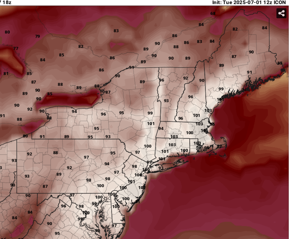
July 2025 Obs/Disco ... possible historic month for heat
Typhoon Tip replied to Typhoon Tip's topic in New England
Heh ... ICONological heat this next Monday, huh -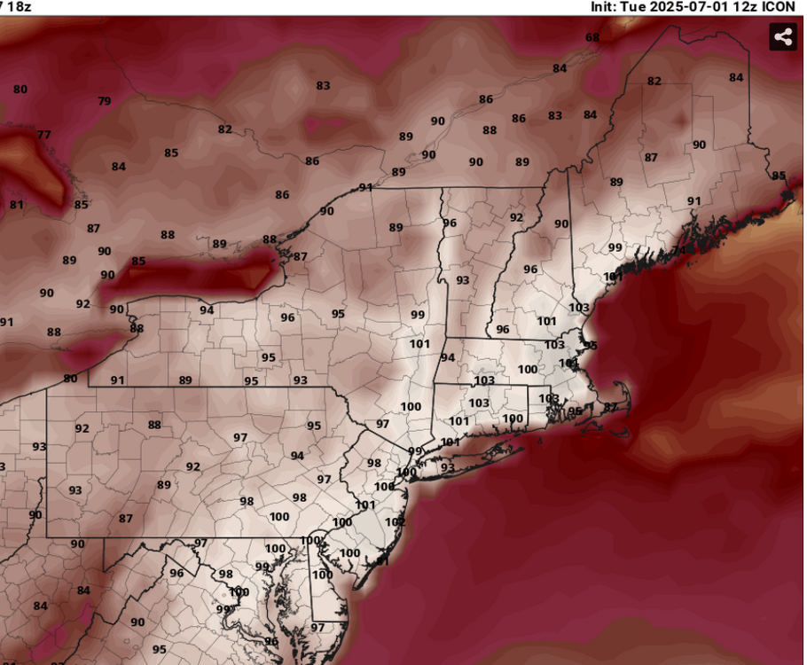
-
Im feeling slighted....Im only at 25.16". Rationing could mean LESS precip in the prime "winter" months.
-
A lot of us need to dry out. At least 10 days without any rain.
-
July 2025 Discussion-OBS - seasonable summer variability
SACRUS replied to wdrag's topic in New York City Metro
86 / 77 steaming away Florida syle -

July 2025 Discussion-OBS - seasonable summer variability
psv88 replied to wdrag's topic in New York City Metro
85/77/96. Yikes -
Watch coming soon per MCD https://www.spc.noaa.gov/products/md/md1529.html
-
I have an appointment tomorrow with a lung specialist. A recent test showed something of concern (non-cancerous, they believe) so I'll have a better idea of what's happening soon. Current thought is that the chest infection that started all of this back in April might have caused permanent damage. Right now there's just too much unknown for me to really say more. I'll update when I'm able to. Overall, I feel better than I have in years, ironically.
-
Storms initiating jokerandherewego.gif
-
every simulated radar fires up storms just east of here. Hope they are all wrong lol