All Activity
- Past hour
-
Maybe. My older brother was in the Corps of Engineers and during the monsoon season of his Vietnam year (1967 into 68) there would be thunder and torrential rain 3-5 PM, so regular that one could almost set one's watch by the storm times.
-
The new (12Z) UKMET has nothing from the lemon designated as a weak TD, unlike the prior 3 full runs. However, Pivotal’s UK maps still have just about the same as a weak TD (a closed weak sfc low) along a similar track. It approaches SC late on 7/2 and comes into SC with hardly any circ. but with strong and persistent convection for S SC on 7/3-4 with a max of a whopping 9” 35 miles W of CHS before the convection heads NE up the Carolinas’ coast 7/5-6. That very heavy precip though is a major outlier vs other models and thus is highly unlikely as of now.
-
Also not sure if it was talked about but the GFS was all over this mid to late week heat wave while the EURO had no interest in it. Another impressive mid to long range win for the GFS.
-
I more have a problem with this paragraph. “The US will endure one of its most expansive heatwaves in history this week. Then another long lasting record breaking heat dome will plague #Europe again, back to back on its worst #heatwave in its history!” Every anomalous outbreak doesn’t have to be dubbed “worst in history” . As you stated earlier there have been higher temperatures recorded much more humid air masses and more dangerous/long lasting heat waves. Let’s see where this one ranks when all is said and done. Now if we actually hit 100-104 over a large number of climo sites plus humidity that’s a different ball game. However it seems like we do 95-99 for a week stretch every year.
-
Outside after a scattered t-storm is brutal. Sure the temperature is lower, but with all the evaporation from that storm and the lower temp, the air is much closer to saturation. It is the worst sticky soupy feeling. Much prefer the low RH with the triple digit heat that comes before.
-

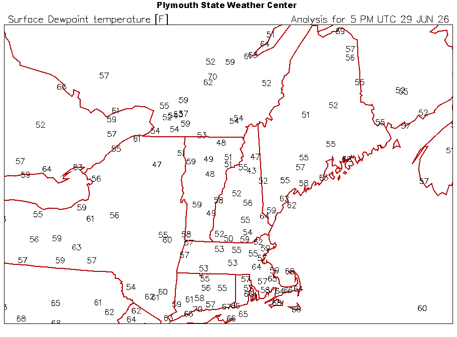
Junorch obs and discussion 2026
CT Valley Snowman replied to Damage In Tolland's topic in New England
Deep, deep summer week. Big heat, big dews, hopefully big storms. -
The new (12Z) UKMET has nothing designated as a weak TD, unlike the prior 3 full runs. However, Pivotal’s UK maps still have just about the same as a weak TD (a closed weak sfc low) along a similar track. It approaches SC late on 7/2 and comes into SC with hardly any circ. but with strong and persistent convection for S SC on 7/3-4 with a max of a whopping 9” 35 miles W of CHS before the convection heads NE up the Carolinas’ coast 7/5-6. That very heavy precip though is a major outlier vs other models and thus is highly unlikely as of now.
-
81/48 Gah it’s so nice outside. Drinking in these dews before the swamp arrives.
-
i was being facetious lol. I do remember somewhat frequent brownouts due to heat in the mid-late 1990s.
-
My west facing analog therm has hit 100+ several times already this year :-)
-
I'm going by the Staunton official records. A thermometer exposed to the rays of the sun or other artificial heating can register significantly higher than actual air temperature. Even reflective heat can artificially inflate the temperature.
-
Fireworks Heat Contest W 7/1 - S 7/4 for Five MA Airports
Roger Ramjet replied to nw baltimore wx's topic in Mid Atlantic
DCA: 96, 101, 102, 100 BWI: 97, 102, 101, 99 IAD: 96, 102, 101, 100 SBY: 95, 100, 100, 99 RIC: 98, 103, 102, 101 Total Rain: 0.00 -
Damn! If that’s true, that’s kinda bananas. Was going to Gilgo and wanted to see about any possible rip currents during the morning and the site was down. And then when I saw the heat models being posted in this thread for this week, when we got back, went to NWS and saw it was still down.
-
Models are always bad in mesoscale season, as you know. At least this website is back to normal speed. Saturday had Crossville special written all over it. I gave up mid-afternoon after cells near Pikeville looked like crap. Then at sunset while I'm back home enjoying the World Cup, tornado warning Cumberland Co. What a hobby!
-
no shortage of warm air and 70+ dps on the gfs, even selling some widespread 80+ dps into fantasy range
-
For tomorrow URGENT - WEATHER MESSAGE National Weather Service Baltimore MD/Washington DC 1243 PM EDT Mon Jun 29 2026 MDZ502-WVZ050-055-502-504-506-300100- /O.NEW.KLWX.HT.Y.0003.260630T1500Z-260701T0000Z/ Central and Eastern Allegany-Hampshire-Hardy-Eastern Grant- Eastern Mineral-Eastern Pendleton- 1243 PM EDT Mon Jun 29 2026 ...HEAT ADVISORY IN EFFECT FROM 11 AM TO 8 PM EDT TUESDAY... * WHAT...Heat index values up to 102 expected. * WHERE...In Maryland, Central and Eastern Allegany County. In West Virginia, Eastern Grant, Eastern Mineral, Eastern Pendleton, Hampshire, and Hardy Counties. * WHEN...From 11 AM to 8 PM EDT Tuesday. * IMPACTS...Hot temperatures and high humidity may cause heat illnesses. PRECAUTIONARY/PREPAREDNESS ACTIONS... Drink plenty of fluids, stay in an air-conditioned room, stay out of the sun, and check up on relatives and neighbors. Take extra precautions when outside. Wear lightweight and loose fitting clothing. Try to limit strenuous activities to early morning or evening. Take action when you see symptoms of heat exhaustion and heat stroke. To reduce risk during outdoor work, the Occupational Safety and Health Administration recommends scheduling frequent rest breaks in shaded or air conditioned environments. Anyone overcome by heat should be moved to a cool and shaded location. Heat stroke is an emergency! In cases of heat stroke, call 9 1 1.
-
Off and on showers - little bit of additional accumulation... Everything just feels and looks a bit better after last evenings rainfall... Fresh mulch with some rain on it has a nice smell at least to me...
-
Just an insane presentation still. Even looks like there may be a rain wrapped tornado
-
Got this message from work. NYC Emergency Management has implemented their flash flood emergency plan due to thunderstorms. I don't see any thunderstorms in the forecast for NYC today or tomorrow and a 20% chance on Wednesday.
-
This thing is still chugging along through the forests of Minnesota. HRRR says Canada denies it entry, but would be cool to see this thing survive and arrive tomorrow morning.
-

2026-2027 Super El Nino
40/70 Benchmark replied to Stormchaserchuck1's topic in Weather Forecasting and Discussion
Agree...it will also be well above in the mean because were aren't getting cold of that magnitude, nor as protracted later in the season. I am NOT trying to imply that this year will be like the colder basin-wide seasons like 2002 when I call it basin-wide. -

Fireworks Heat Contest W 7/1 - S 7/4 for Five MA Airports
MN Transplant replied to nw baltimore wx's topic in Mid Atlantic
DCA: 95, 100, 101, 97 BWI: 95, 100, 101, 97 IAD: 95, 100, 101, 97 SBY: 91, 98, 98, 98 RIC: 95, 98, 99, 99 Total Rain: 1.34" - Today
-
*forgets sunburn won't be a thing*
-
My front lawn is on a small hill facing north under a tree. Trees line the curb on the other side of the sidewalk. I would love turf to keep the leaves from settling in between blades and creating bare spots. In addition to the moss that takes over because of the north facing lawn with low sunlight. I thought about putting fake grass down. lol
-
I dunno man, the thermometer at Westside pool in Staunton's west end had frequent 100+ readings back in the 1990s!


