All Activity
- Past hour
-
Nice day. 38.6 for the high (surprised it didn’t go higher). All the ice on the creek has melted except for further inland coves.
-

February 2026 Medium/ Long Range Discussion: Buckle Up!
Terpeast replied to Weather Will's topic in Mid Atlantic
Thats been the theme for 6+ months now -
The radar in Kentucky looks impressive, hopefully it works through Tennessee.
-

Central PA Winter 25/26 Discussion and Obs
CarlislePaWx replied to MAG5035's topic in Upstate New York/Pennsylvania
@canderson Did a quick search and it looks almost certain that Home Depot would have it. I think you are referring specifically to a garden spade, which is metal and is shaped like a rectangle at the base. $20 - $50. -
-
Surface is 32 to 33 here in north knox. Had some sleet mixed in with drizzle. Was mostly drizzle last I checked. Could get ugly if temps keep dropping and we don't get the switch to snow. I don't think anyone is paying attention to this and roads could get bad quick.
-
That's a miller A signal the Euro AI. the others have a miller B...... With the current south trends, I would not count out an all-snow event.
-

February 2026 Medium/ Long Range Discussion: Buckle Up!
BristowWx replied to Weather Will's topic in Mid Atlantic
It ain’t over. I didn’t hear no bell. -

February 2026 Medium/ Long Range Discussion: Buckle Up!
Steve25 replied to Weather Will's topic in Mid Atlantic
Seems like the general trend across guidance today is the push back of the cold air next week quicker and stronger against that ridging. -
It was that here earlier today before it switched to snow. The clear ice from the rain and snow is now white again, any even my vehicle, which had been warm from driving is covered again. What is your surface temp?
-

Fall/Winter Banter - Football, Basketball, Snowball?
tnweathernut replied to John1122's topic in Tennessee Valley
There are a lot of boat owners, a marina, and an insurance agent having a very bad day…… -

February 2026 Medium/ Long Range Discussion: Buckle Up!
mitchnick replied to Weather Will's topic in Mid Atlantic
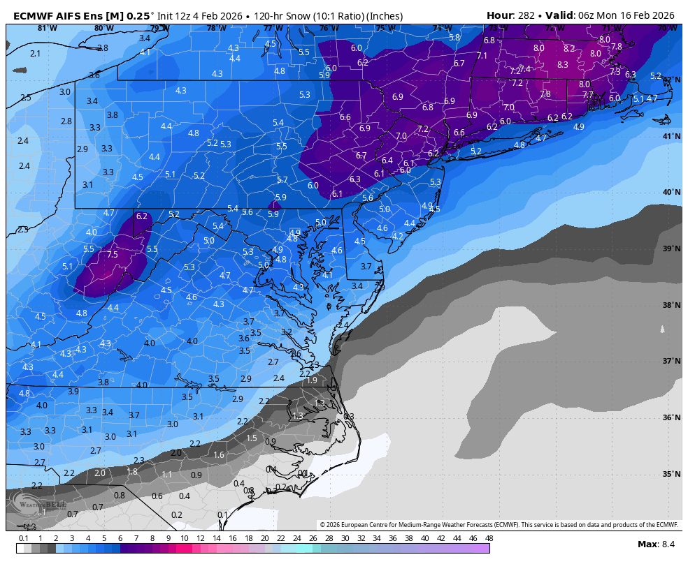
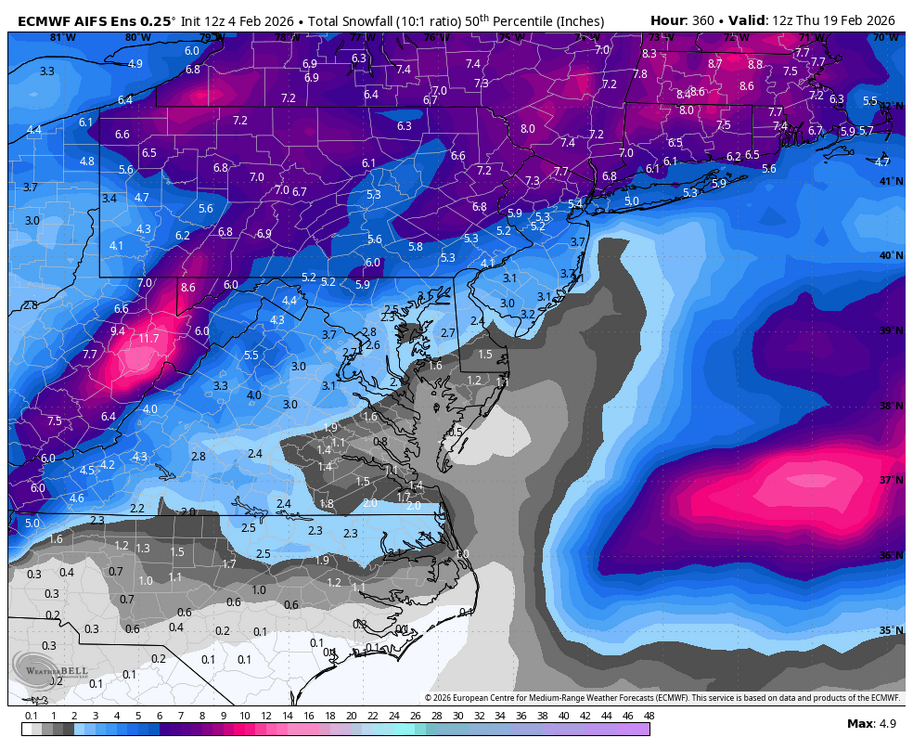
Don't you love that purple over our back yards? Lol -
February 4, 2018

-

February 2026 Medium/ Long Range Discussion: Buckle Up!
psuhoffman replied to Weather Will's topic in Mid Atlantic
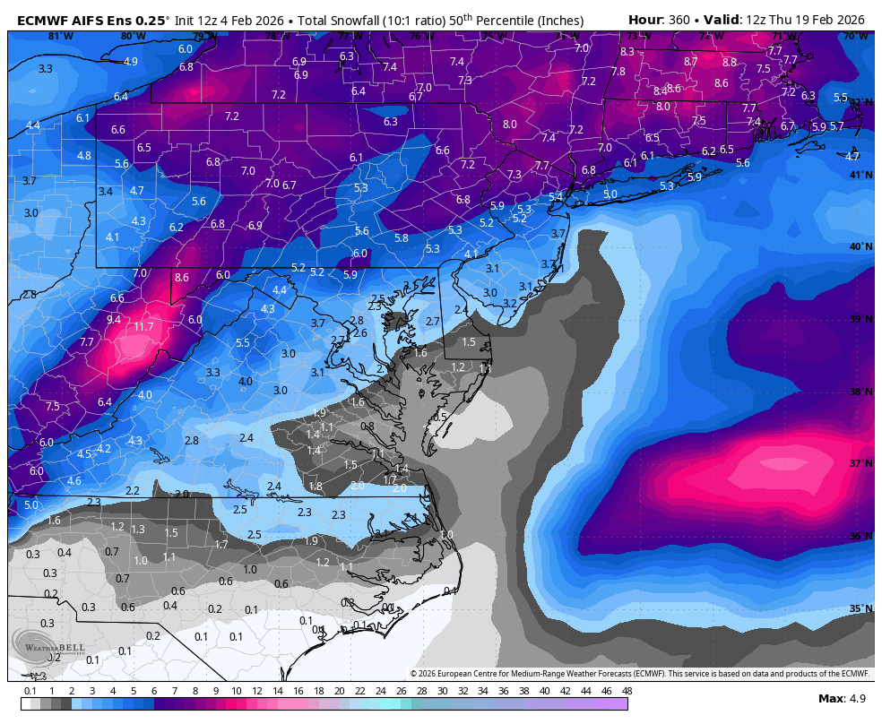
Who TF said the AIFS lost interest? It’s was the strongest signal across all the 12z guidance. mean more importantly the median is improving
-
Depends on who we're talking about.
-
DRY HERE
-
February 2026 Medium/ Long Range Discussion: Buckle Up!
mitchnick replied to Weather Will's topic in Mid Atlantic
I think that was Heisy. I was in MD driving all around the beltway down I83 instead of the west side of the Beltway thanks to an accident that closed the west side for 4hrs+. Effers! -
February 2026 Medium/ Long Range Discussion: Buckle Up!
psuhoffman replied to Weather Will's topic in Mid Atlantic
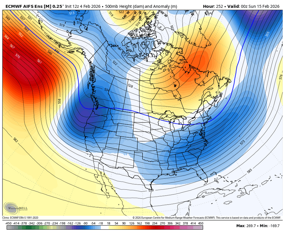
All the models have that lead wave but it’s been mostly weak and way north so we weren’t paying attention. But given the seasonal trend it could shift south. And it will impact what happens after so we should pay attention. -

February 2026 Medium/ Long Range Discussion: Buckle Up!
CAPE replied to Weather Will's topic in Mid Atlantic
It has been suggestive of a wave or 2 between the 9th and 12th on recent runs. There is some decent vorticity being puked out from the upper low digging south along the west coast of Canada and riding overtop the de-amplifying ridge as it shifts eastward. Also some energy ejecting eastward from the SW. Wouldn't it be something if there was enough interaction as those pieces head east to make something happen before the window we are focused on lol. -

February 2026 Medium/ Long Range Discussion: Buckle Up!
Climate175 replied to Weather Will's topic in Mid Atlantic
For sure! -
-

E PA/NJ/DE Winter 2025-26 Obs/Discussion
Birds~69 replied to LVblizzard's topic in Philadelphia Region
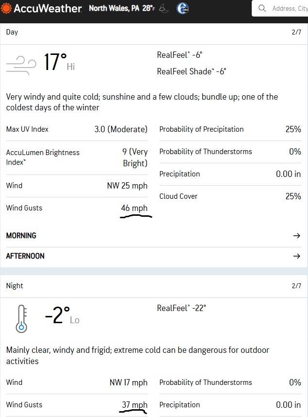
Sat may be the coldest day so far this winter (real feel) with the wind and temp...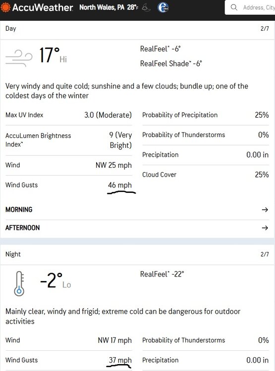
-
There ended up a few days of +10 between the 8th and 15th, just nothing high end. We wedged through anything substantial. There was a stretch in late dec when the weeklies flopped warmer and there were alot of cancel winter calls. I Remember scott coming back from the tropics ready to drive into the harbor.
-
Extreme warmth is spreading through BC, Alberta and the PAC NW. Temps in low 70s on the Oregon coast with sunshine, easterly breezes. Near 60F around Vancouver and Seattle. Also into high 60s and low 70s in chinook zones of s Alberta and e/c Montana. Nearly 50F here with sun poking through strato-cumulus ragged overcast with a base just above our elevation of 3300' asl. Needless to say this is finishing off what little snow is still on the ground in town, will probably survive around the ski hills. It has been snow-free for days now at lower elevations than the town, down into Columbia valley. Still a lot of cloud in e/c WA so not warming up as fast yet there. Spring fever, have seen a few younger people dressed like it was late April roaming the streets. In some cases you rather wish they wouldn't.
-
IIRC there were a few unbelievable OP runs showing a day or two supporting 70° and then the models obviously backed off from that. But then there was the windshield wiper effect where some didn’t think we were going above the 30s and it ended up being a week well into the 40s.