All Activity
- Past hour
-

June 2025 discussion-obs: Summerlike
LongBeachSurfFreak replied to wdrag's topic in New York City Metro
60s would have been nice, right on the ocean it struggled at 59 for most of the day. The cloud deck was so thick there was almost no noticeable warming even in the afternoon. -
39° and rain Friday afternoon. What a way to start the weekend.
-
It seems to come a tropical downpour here around every 2 or 3 hours, all day and all night and that forecast looks to hold through about Thursday. We may get hot after that, but it's so wet, it's tough to get too hot here. It will take some soil drying to pull it off.
-
Could definitely use some in fallston area - mostly a whiff over the weekend so far - so something overnight would be welcome.
-
Lots of places 2” plus. Got zero here crazy. We could use a little
-
I will probably be fact checked, but I really can't remember a 3 day stretch (yesterday today and tomorrow) so far into June that stayed in the 60s.
-
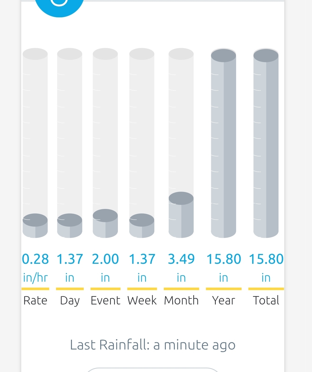
Up to 1.85 in today and it is still raining. EDIT: Looks like it has finally stopped and today's total was 1.91 in.
- Today
-
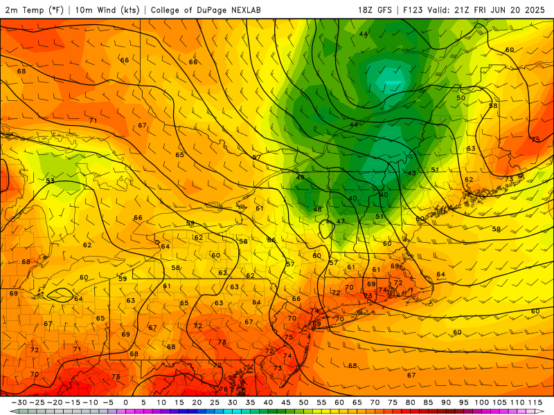
Big heat and humidity hit this weekend and look to last without a real end in sight. That short wave Thursday looks legit. Major severe potential for nearly the entire state, depending on timing.
-
We haven't done squall lines well at all in the Mid-Atlantic in recent years, but this setup certainly favors very organized intense convection. Pop-up stuff occurs with weak forcing, and the cold front arriving during peak heating (and it should plenty hot with high dew points) with a modestly strong upper level trough will provide strong forcing.
- 1,034 replies
-
- 1
-

-
- severe
- thunderstorms
- (and 2 more)
-
Could be, or it could just be low-level speed convergence which is kind of hinted at on a few HRRR 850 mb images. Regardless, us Howard County folks look to be left out of the show again......
-
Dry weekend here so far. Today was nice for planting, I'm another who did that. Maybe some hope on radar.
-
Parr's Ridge is a force. It could be dry on my commute to Columbia and then a sprinklefest as I pass Mt. Airy.
-
Starting to see this on radar. Wonder if it's southeast flow interacting with Parrs Ridge?
-
Misery mist city.
-
Still pouring, yellows and oranges just rotating across NoVA.
-
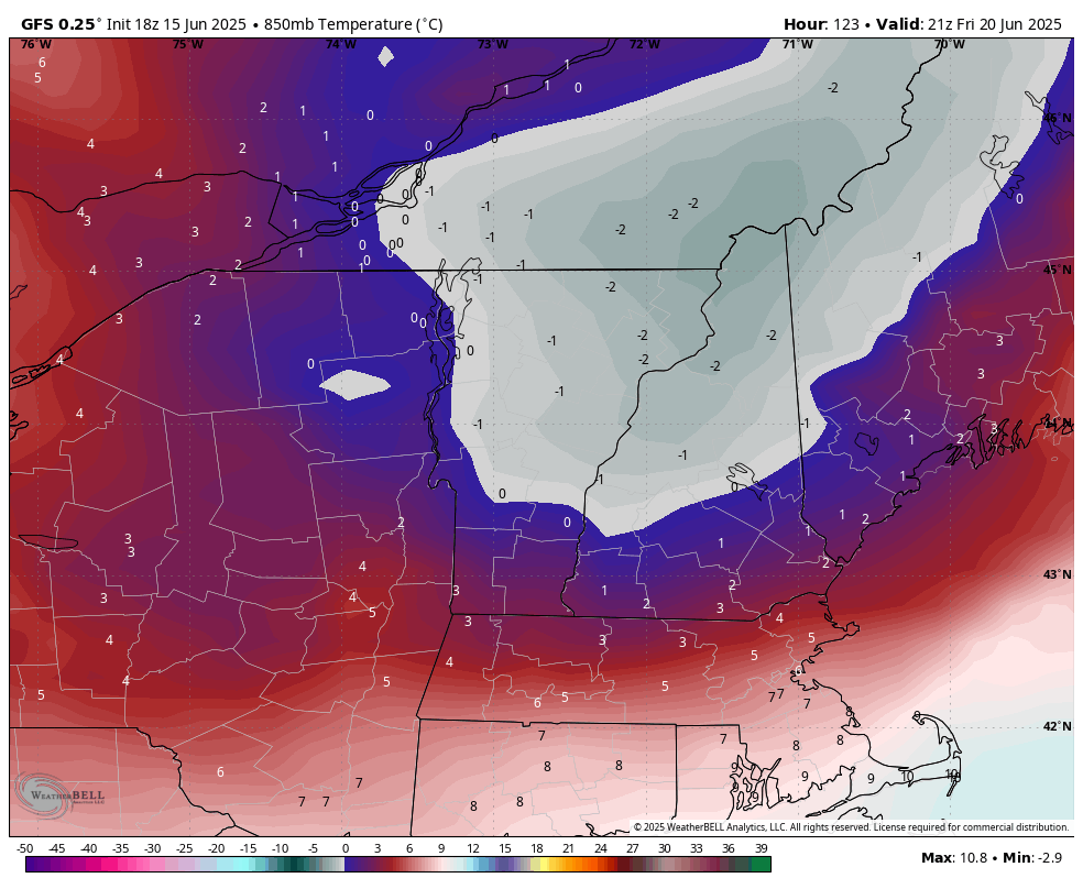
What is the gfs bringing through nne fri afternoon?
-
And more to come. Starting in July policy will be for the forecast to be populated with the NBM and largely left alone except for the near term. But we are wasting human resources generating dewpoint grids on day 7 given the current staffing situation.
-
a number of recent HRRR runs break out an area of heavy precip over north-central and northern Maryland later this evening. It doesn't appear to be a northward propagation of the existing rainfall. Curious to see whether the HRRR is onto something.
-
Major heat wave odds are increasing for the Mid Atlantic between June 22 nd and June 25 th.
-
Still raining

-
.05 total over the weekend.
-
Brief mild up.
-
Hold everything with this heatwave malarkey. Ineedsnow have you seen 18z GFS? Moves a little southeast and we're in business!

-
1.62” since about 5pm today, still going at a moderate clip.