All Activity
- Past hour
-

2026-2027 Strong El Nino
40/70 Benchmark replied to Stormchaserchuck1's topic in Weather Forecasting and Discussion
Kind of analogous to ENSO in that the PDO cycle itself is still operating as it always has, however, the baseline warming is limiting it's ability to drive the weather pattern around the hemisphere. Interesting. -

Richmond Metro/Hampton Roads Area Discussion
Deep Creek replied to RIC Airport's topic in Mid Atlantic
Unless we get a freak monsoon today, gonna finish with 0.97” of rain IMBY for the month. To go along with 1.95” in March. Yeesh -
Steindrite
-

Central PA Spring 2026 Discussion/Obs Thread
mahantango#1 replied to Voyager's topic in Upstate New York/Pennsylvania
.53 rain for the event. -

2026-2027 Strong El Nino
GaWx replied to Stormchaserchuck1's topic in Weather Forecasting and Discussion
Snapshot current RONI equivalent appears to me to be fairly steady near +0.3C (temporary pause). -

2026-2027 Strong El Nino
bluewave replied to Stormchaserchuck1's topic in Weather Forecasting and Discussion
Yeah, I get the joking. It’s good to keep things light in here. We switched out of the traditional -PDO +PDO relationship following the big warming east of Japan after the 2015-2016 El Niño.This really increased following 2018-2019. So the current models are forecasting more of basin-wide warming where we get a zone of warm SSTs from Japan to the Baja. We saw that this past winter going into the spring with the record +PMM and remaining warm pool east of Japan. We will probably have to revisit this paper again after this event and see where things stand. https://www.nature.com/articles/s41558-025-02482-z Pan-basin warming now overshadows robust Pacific Decadal Oscillation The Pacific Decadal Oscillation (PDO) has served as a key index linking basin-scale climate variability to marine ecosystem changes in the North Pacific. However, recent apparent breakdowns of PDO–ecosystem correlations have raised concerns about the stability of the mode and its continued relevance in a warming climate. Here we show that basin-wide warming now overwhelms PDO-related sea surface temperature (SST) variability, although neither the PDO’s spatial pattern nor its strength have changed. We introduce the pan-basin pattern as a complementary index to describe the non-stationary SST baseline of the North Pacific. Regional SSTs increasingly reflect the superposition of these two signals, providing an explanation for weakened or inverted PDO–ecosystem correlations. Future use of the PDO index in management will require discerning the effects of internal dynamics from those of absolute changes in SST as extreme and no-analogue ocean conditions driven by interacting natural variability and anthropogenic warming become more common. We demonstrate that the leading mode of interdecadal North Pacific SST changes recently transitioned from the PDO to a pattern of unidirectional change across the entire basin (that is, the PBP). For the first prolonged period of the recent observational record, a negative ‘cold’ PDO phase failed to coincide with cool SST anomalies in the eastern Pacific—a harbinger of the increasing non-stationarity in relationships between the PDO and regional SSTs (Fig. 3d,e). Despite explaining proportionally less variance, ongoing robust PDO variability indicates that drivers of the mode’s SST anomaly footprint have been resilient to warming through the early twenty-first century (Figs. 1 and 2). As the PDO is a statistically emergent pattern integrating several processes (for example, stochastic Aleutian Low forcing, teleconnections with the tropics, and ocean Rossby waves)4,47, its future evolution will depend on how these contributing processes are cumulatively impacted by warming across timescales. Although the historical physical drivers of North Pacific decadal variability are relatively well understood4,48, the biophysical mechanisms through which ecosystems respond are less so. The PDO has historically served as a reliable proxy for SST in much of the North Pacific. However, as regional SST anomalies continue to diverge from those historically expected based on PDO signals (Fig. 3d–g), there will be a growing need to distinguish impacts associated solely with SST anomalies from those produced by the dynamics related to the PDO (for example, changes in upwelling, transport or source waters). For example, since the 2021 transition into the negative PDO phase (Figs. 3d,e and 4b,c), warming is superimposed on a cold PDO regime in the eastern North Pacific, leading to confusion in the community regarding the expected biological effects26. Further investigation into the mechanisms behind PDO–ecosystem relationships should prioritize discernment of temperature-specific effects on biology from the effects of other physical or biogeochemical processes. Given the ongoing stability of the PDO pattern, the PDO index probably remains a useful indicator of North Pacific climate variability, but perhaps with its ecological relevance in how it reflects changing dynamical processes rather than regional SST anomalies. As the PBP–temperature baseline climbs in concert with global ocean warming, local and regional SST anomalies that would historically have been associated with an exceptionally strong PDO and/or El Niño (for example, >2 standard deviations) will occur more frequently. For example, constructive signals between internal variability and secular warming from 2014–2020 contributed to warm temperature extremes during this period (for example, ref. 49). Quantification of the range of internal variability related to the PDO and other modes will be needed to constrain the potential for climate extremes resulting from interaction of internal variability and anthropogenic warming, leveraging approaches such as palaeoclimate records, long model simulations or large model ensembles50,51. Constraining internal variability and stability is also necessary for understanding the future of PDO impacts beyond the North Pacific (for example, theorized impacts on hydroclimate in western North America and northeastern Asia)52,53,54,55,56,57 and its role in modulating global climate. Global-scale trends and internal variability are now both important determinants of North Pacific climate48,58, with the influence of pan-basin warming surpassing that of the PDO within the past decade. The combination of long-term warming and natural variability has already begun to produce profound physical and ecological changes throughout the North Pacific, including severe marine heatwaves with ecosystem-wide impacts59,60, rapid sea ice declines and novel weather patterns in the Alaskan Arctic61, and new human–wildlife conflicts62. Management decisions based on historical baselines will fail to capture increasingly important emergent interactions between anthropogenic warming and internal variability. This increased uncertainty in associations between basin-scale variability and regional responses underscores the need for management approaches to incorporate dynamical modelling and prediction of North Pacific climate (for example, ref. 63), rather than relying on historical relationships with basin-scale indicators as predictors. Given that the internal variability of the North Pacific is especially strong, a similar emergence of pan-basin warming over internal variability is probably already occurring in other basins, suggesting that the recontextualization of indices of climate variability under warming is needed widely. -
Sucks to have to water in April. I have been doing it for a couple weeks.
-
0.55 last night. 1.10 for the week.
-
0.11”
-

Central PA Spring 2026 Discussion/Obs Thread
Blizzard of 93 replied to Voyager's topic in Upstate New York/Pennsylvania
I tacked on .08 overnight. Event total .68 -
.06"/ 44F
- Today
-
0.03 for me . Ironically, I watched ol' Germantown where I used to live (and complain about missing rain) getting a nice soaking on radar LOL. I think my April total is close to zero, maybe a couple tenths. I've never seen such a dry April and I'm trying to grow a brand-new lawn. Ooof
-
Ground is about 50% covered with 3-6" remaining. Two swampy areas near the house each still have close to a foot, and just eyeballing outside this morning looks like 2-2.5 of fresh snow fell overnight coating everything. Cool today and tomorrow with highs in the upper 30's with scattered snow showers.
-

2026-2027 Strong El Nino
snowman19 replied to Stormchaserchuck1's topic in Weather Forecasting and Discussion
-
Looks like a couple of showers here Saturday then we get brushed by a coastal Sunday morning. Maybe something else late tonight early tomorrow morning
-

2026-2027 Strong El Nino
roardog replied to Stormchaserchuck1's topic in Weather Forecasting and Discussion
Just having a big typhoon season would be a big change compared to recent years. -
.70", 3.50" for the month.
-
0.80". Keep it going Sent from my SM-S921U using Tapatalk
-
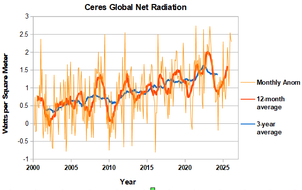
Another large positive net radiation balance in February, further increasing the running 12-month average. Should be near an enso peak in the running 12-month avg, as the transition to nino is underway. Combination of high net radiation and nino transition should fuel a healthy rise in global temperatures for the rest of the year. We will see. https://ceres-tool.larc.nasa.gov/ord-tool/jsp/EBAFTOA421Selection.jsp
-
0.14" Nice to see there is another chance for a tenth of an inch or less on Friday night into Saturday!
-
.71 today for a total of 1.11 since Saturday.
-
46F and .12 of rain so far
-
 DCA _ NYC _ BOS _ ORD _ ATL _ IAH _ DEN _ PHX _ SEA .6 .7 .5 .4 1.1 1.0 1.9 1.9 1.3
 -

Central PA Spring 2026 Discussion/Obs Thread
Jns2183 replied to Voyager's topic in Upstate New York/Pennsylvania
A little thought experiment. What do you feel is the worst case meterological scenario rack the lower Susquehanna valley has a realistic chance of facing the rest of this century. Something that doesn't get talked about enough for this area is the setup that truly keeps me up at night. It's a deep Greenland block anchoring a stationary front right along the spine of the mountains to our west, timed perfectly with a tropical system on approach. The PRE (the days before lee featured a pre, and it wouldn't have taken that much different timing for hurricane Katia which fed the pre, to be this storm) Days two and three before landfall, small shortwaves combined with a tropical depression remnant riding up over a stalled front to our West in the mountains due to a strong, south based, slowly retreating rex block, low level moisture from our hurricane start training over the same geography repeatedly. Due to the angle of approach the moisture tap is already running full blast hundreds of miles ahead of the center. We're talking three to eight inches of rain before the storm even gets close. Ground is done. Fully saturated. Soil is weakened around every root plate in the metro. Then the approach angle shifts. Forward speed jumps from maybe ten to thirty mph as the block partially erodes and the storm finds its exit. The damage from that sequence is already locked in before a single tropical wind gust arrives. Now put the track just west of the valley so we're sitting in the right front quadrant, winds from the southeast, additive component of forward motion stacked on top of rotation. Even if the winds only land somewhere between Hazel and Sandy that's a catastrophic tree loss event on a seventy year old suburban canopy that has never been tested. The part nobody plans for is the utilities. Crews are staged south for whatever hit the coast first. Forecast uncertainty from the block interaction blew the seventy two hour window you need to pre-position resources here. The SSE wind vector exposes trees weakest side to worst winds. Many of the roads 5-10 minutes from camp hill basically have a tree canopy for miles due to how thick and close the trees grow. Those roads become impassable with 20+ trees blocking it per mile in heavy forest. All those railroads like that taking away from two to four weeks actually become open We get weeks without power in a lot of places, not days. The situation in rural areas is more similar to Helene and Katrina with being cut off. This is one where overall emergency managers can make the correct statistical rational choice and because of timing and non linearity it still becomes a disaster like none other. The same setup that sends the the cat 4 at landfall hurricane rocketing up here at 30-50 mph (hazel which saw 98mph at DC and close to it in York was only going 30mph while the 38' hurricane through Long Island was at 55mph and that Forwardvmotion gets added to the winds on the east side) is the one that stalls the front, pierce the low-level tropical moisture into it causing the pre. So that is it. My crazier 1 in 10,000 year scenario for it even happening on the east coast period involves an upper Midwest drought not unlike the one preceding the 1871 Pestigo firestorm, a potent shortwave from that direction that perfectly hits a window of just an hour or two to cause the rapidly coming storm to occlude in a manner that produces a stinger jet like the 1987 storm that hit the Uk. A small area the size of the lsv on the south to ssw flank would be in overlap area due to shape of Appalachian mountains and track. The stinger jet would produce gusts over 125+ with sustained over 85. That area would of overlap with insane tornado parameters that in the perfect situation would give us (early October) cape above 2200, SRH 450+ with 135 degree turning between 850 and 500mb. STP estimated at 8+ easy, LCL 250-500 meters. The model producing these values went ape shit especially due to dry air from upper Midwest. It's one of those things that's possible but so far unlikely that planning is fruitless. That 1 in 10,000 year event was just the pieces coming together like this. You can't even. Calculate a return period for alot if areas due to Continental drift and long term climate. But hey, if your area manages to get a stinger jet and ef4 tornados from the same system I'd bet the on the Apocalypse happening before I would bet on being random weather. Sent from my SM-S731U using Tapatalk


