All Activity
- Past hour
-
Icon shows rain on precip depiction up to PA but has the 32 line down across DC. Decent looking track I’d take
-
What??? No Thanksgiving??? I’m cooking for an army so you’re welcome here!
-
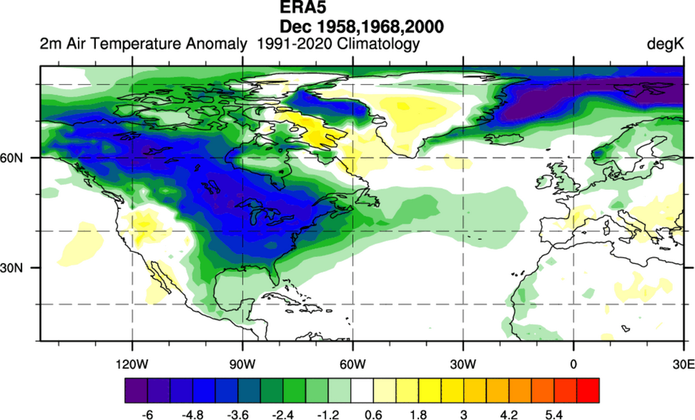
Interesting, past times when we had a warming.
-

Central PA Fall Discussions and Obs
Voyager replied to ChescoWx's topic in Upstate New York/Pennsylvania
Sure. Just in time for me to go back to hauling water. But that may be a good thing. New (old) boss doesn't really want his trucks out in snowstorms. Present company isn't like that. They want you moving if it's legal and the roads aren't restricted. -

December 2025 regional war/obs/disco thread
Ginx snewx replied to Torch Tiger's topic in New England
Lock up big windsexy day for you Friday maybe a squall or 2 here. No more its coming its here. -
Your work deserves lots of positive feedback. I know it was a huge effort and I know it is filling a void in at least my neck of the woods. Much appreciated, hopefully I’ll have lots of reports this season to reply to you with.
-

2025-2026 ENSO
michsnowfreak replied to 40/70 Benchmark's topic in Weather Forecasting and Discussion
Blizzard ongoing in the western U.P. of MI. Between a synoptic dump and lake effect The western UP will easily see 2-3+ feet of snow. Jealous is an understatement. Snow squalls will hit the entire state of MI, with accumulations ranging from a dusting to 18" depending on location. Winds gusting 45-55mph. Lake snow warnings also up in upstate NY. The gales of November are roaring and winter has arrived. Coming to New England shortly. -
I hate even typing or mentioning his name because I feel like my IQ drops just doing it, but I literally have no words for the absolutely asinine wishcast from Mark Margavage that there is going to be a major SSWE and a total wind reversal by Christmas. Not grounded in any semblance of reality. It’s not even worth discussing that idiocy from a man who failed out of meteorology school and does stolen valor/blatant lying, claiming to be a degreed professional met who’s a “winter weather expert”. It’s a total disgrace and the type of complete garbage I’d expect from a bozo like him
-
Miller Lite (snow), Bring on the B's and SWFE's.
-
Bring it home and we will name this storm after you.
-
That cold over Canada on the ICON is legit. Lack of sleep is going to be an issue over the next few days.
-
Appreciation post for getting the mild out of the way today followed by cool Tgiving weather. I'm not even doing Tgiving and I'm so glad lol.
-
.thumb.jpg.ad3a2e31d30aff035044689b311a0540.jpg)
Nov 28-30th Post Turkey Day Wintry Potential
nvck replied to Chicago Storm's topic in Lakes/Ohio Valley
If snow really makes it to Cincinnati on Saturday .... I'd be shocked to say the least lol -
I must have missed where somebody did that?
-
It’s a light hit of snow before mostly ZR, but nice to have it in the ballpark of a better outcome.
-
When i made mention of that season yesterday, Your pictures were what came to mind but i didn't remember who it was, That was downright depressing.
-

E PA/NJ/DE Autumn 2025 Obs/Discussion
simbasad2 replied to PhiEaglesfan712's topic in Philadelphia Region
The ICON starts the 12z suite off with a pretty heavy ice storm for areas slightly NW of I-95 -

Central PA Fall Discussions and Obs
MAG5035 replied to ChescoWx's topic in Upstate New York/Pennsylvania
OK, I’m in. That pattern next week has evolved into something much more favorable on modelling the last few days since my last post. Gone is dumping the trough in the west and building southeast ridging. Instead, we’re bringing the energy for what is now Sunday’s system out quicker. While that low still cuts, the faster timing and fairly weak low invites a potential light snowfall/mix event in at least interior C-PA with some cold air still in place. So that’s actually the first thing I’m looking at with this period. That system resets the boundary, and we have a nice placement of the PV over Hudson Bay to help push down any semblance of SE ridging and we’re set for this Tues-Wed system that is looking way more wintry than it did several days ago. GFS is obviously a big and widespread snowstorm for a lot of folks. The Euro and Euro Ensemble are in fact showing this system as well. 0z Euro had the widespread precip but a more confined snow area, 6z Euro was shaping to look pretty decent but ran out of hours. Euro GPT doesn’t have it at all and those ensembles are weakly hinting at the system. Key will be a balance of amping this system up enough and placing/strength of the high to the north to set up cold and a more widespread snow swath. The feature itself looks progressive (no closed 500mb low or neg tilted trough) but low originates in the Gulf, so moisture source is there. -

2025-2026 Fall/Winter Mountain Thread
Maggie Valley Steve replied to Buckethead's topic in Southeastern States
Some people love to trash the GFS. It picked up this possibility a week ago. I've learned in my 50+ years of closely monitoring the weather that you use all the tools in the toolbox when analyzing patterns and possibilities... -

December 2025 regional war/obs/disco thread
WinterWolf replied to Torch Tiger's topic in New England
Yup, I think I snapped a picture of it…got absolutely nothing out of it..what a flop. -
Icon at 120. Big slug of moisture primed in the gulf!!

-
You just beat me! I saw the same thing. Decent cold too. https://www.tropicaltidbits.com/analysis/models/?model=icon®ion=us&pkg=mslp_pcpn_frzn&runtime=2025112612&fh=120
-

December 2025 regional war/obs/disco thread
Sey-Mour Snow replied to Torch Tiger's topic in New England
Ya feet of digital snow is usually modeled a few times a week it seems in January and February. But if it were to ever actually happen, December would be so much better. -
Just lost power because of 45-50 mph gusts. We were supposed to host Thanksgiving. Hopefully the power comes back on by morning.
-
Icon might hop on board here .


