schoeppeya
-
Posts
579 -
Joined
-
Last visited


-
Im a natural gas trader, you should look at the Feb contract. Went from being dangerously close to slipping below 3 dollars to rolling off in the mid 7's, feb was a wild ride.
-
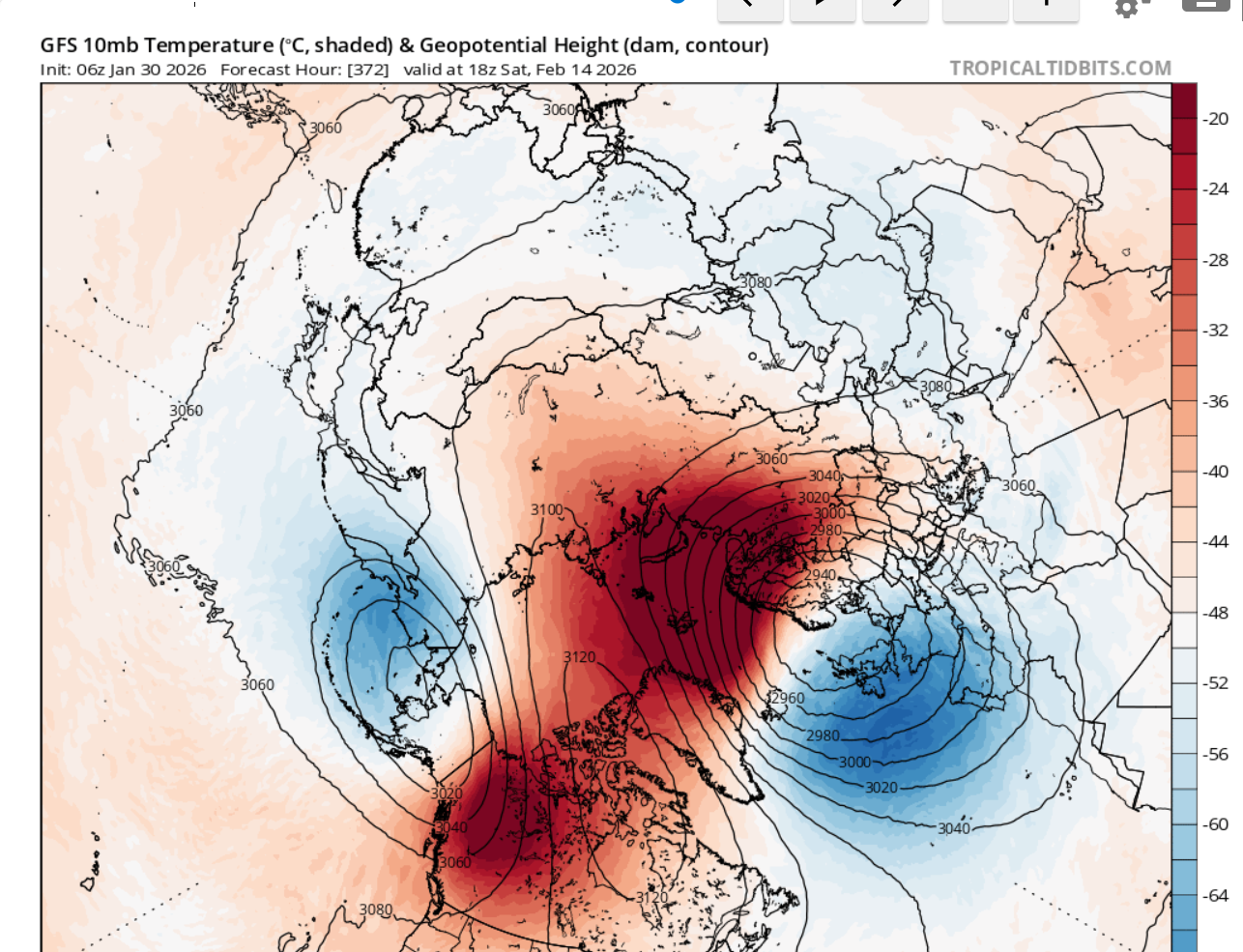
Pretty incredible PV split the GFS is trying to show:

-
That's exactly the response I expected from somebody who results to insults and name-calling every time somebody disagrees with them. For the sake of not derailing anything I will leave you alone, but after you've been horrifically wrong on every "forecast" you've had for this winter, I would suggest a little situational awareness and a little more humility in your approach, for those of us just trying to learn from the "smart" people it makes the thread really hard to read.
-
To start winter? I think he posted like two weeks ago we were having a classic front-loaded winter just before a massive winter storm materialized.
-
Yeah also thinking the 500 mb pattern on the ensembles suggests more coast to coast cold as opposed to the west torching and the east way bn. Should be a fun period.
-
Where'd @snowman19 disappear to
-
MO/KS/AR/OK 2025-2026 Winter Discussion
schoeppeya replied to stormdragonwx's topic in Central/Western States
Round 2 performed here, I measured 8.5 in my yard and I would bet 7 inches of that came last night. Always will be the what could have been if round one hadn't been a dud and we hadnt sleeted most of the afternoon yesterday but 8.5" is a huge storm here and I will take it. -
MO/KS/AR/OK 2025-2026 Winter Discussion
schoeppeya replied to stormdragonwx's topic in Central/Western States
Looking around at current storm reports it does look like a lot of areas performed within expectations for round 1 with a lot of 5-6" reports both north and south of Tulsa... just specifically my area (Jenks/Bixby) up 44 into missouri are the low end spots with a lot of 2 inch reports. -
MO/KS/AR/OK 2025-2026 Winter Discussion
schoeppeya replied to stormdragonwx's topic in Central/Western States
Dry air pockets everywhere and the precip shield back into Texas is decreasing in coverage and intensity not increasing. Becoming less and less optimistic that wave 2 is going to perform let alone over perform. -
MO/KS/AR/OK 2025-2026 Winter Discussion
schoeppeya replied to stormdragonwx's topic in Central/Western States
Yeah that image the HRRR is showing at max .5 inch an hour rates for a couple hours... never truly get up into snow+ on the HRRR for all of round 2. The 3k nam and GFS still show hope so we will see, im leaning dry air wins at this point. ETA: I still dont think the HRRR is initializing the current convection well, maybe something to note. 3k nam was way closer to actual radar. -
MO/KS/AR/OK 2025-2026 Winter Discussion
schoeppeya replied to stormdragonwx's topic in Central/Western States
HRRR is starting to show dry air issues for most the region for round 2 tonight... I know the fat lady hasnt sung yet but starting to look like an absolutely epic bust. -
MO/KS/AR/OK 2025-2026 Winter Discussion
schoeppeya replied to stormdragonwx's topic in Central/Western States
Thats the precip area I was referencing, pretty impressive on radar -
MO/KS/AR/OK 2025-2026 Winter Discussion
schoeppeya replied to stormdragonwx's topic in Central/Western States
Sitting about 2" in south tulsa, I think its going to take a significant overperformance in round 2 to get us to the double digit mark but the radar over sw oklahoma and texas is certainly more impressive than what the HRRR has modeled so I have hope. -
MO/KS/AR/OK 2025-2026 Winter Discussion
schoeppeya replied to stormdragonwx's topic in Central/Western States
Its on an island and getting to a range where the cams start having more weight... its really been pretty terrible with this system since pretty early on. -
MO/KS/AR/OK 2025-2026 Winter Discussion
schoeppeya replied to stormdragonwx's topic in Central/Western States
All of the 0z suite coming in with higher totals this evening as we are less than 24 hours from the show starting... really thinking 12-20" is possible in Tulsa.