All Activity
- Past hour
-
31 in Feb, 24 max depth in 03
-
https://youtu.be/WChTqYlDjtI?si=ihkIV9p-ArrNKPnD
-
Happens i guess
-

Winter 2025-26 Medium/Long Range Discussion
Frog Town replied to michsnowfreak's topic in Lakes/Ohio Valley
I think this includes all of us.. -
Euro is still paltry but all other guidance is 1-3”. Maybe even iso 4” in the western highlands.
-
Everything kind of banged back south somewhat
-

E PA/NJ/DE Winter 2025-26 Obs/Discussion
RedSky replied to LVblizzard's topic in Philadelphia Region
Guidance support today for a PV split and invasion second half of March -
Are you making a forecast map? I'd be interested in seeing it.
-
Lol blessed

-
Def in your area for sure. Your area struggled a bit in December ‘02 after the 12/5 event. Not as bad as the coastline, but Xmas storm there was pretty sloppy and even the 1/3-4/03 storm was much higher totals northwest. So you didn’t build the huge snow pack that northwest of 495 in MA did. Pretty hard to beat Feb 2003 there though. I think the 2/7 event and PD II gave you 3+ feet.
-
18z guidance looked good for SNE
-
perfect for a nice walk in the snow
-

Pittsburgh/Western PA WINTER ‘25/‘26
Rd9108 replied to Burghblizz's topic in Upstate New York/Pennsylvania
Id venture to guess if this plays out that we will be stuck with a warm up and then winter weather returning unfortunately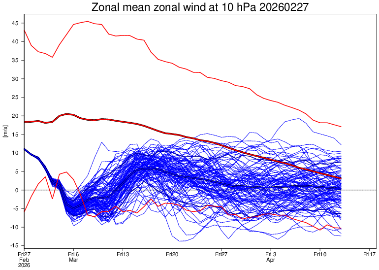
-
72 at MLI, 71 at DVN today. Hit 69 here.
-
Pretty sure that map will end up being quite correct.
-
.thumb.jpg.6a4895b2a43f87359e4e7d04a6fa0d14.jpg)
Central PA Winter 25/26 Discussion and Obs
Yardstickgozinya replied to MAG5035's topic in Upstate New York/Pennsylvania
Tempus fugit. By the middle to end of next week the Spring peeper chorus will will be underway. The caddisflies started emerging today. With the exception of ticks, It'll still be a few more weeks for most biting insects.
-
I seldom cut the lawn before late April or early May, even in the warmest springs. If I did like I'm told and threw down early season fertilizer, i suppose I might have to cut it earlier. Most years I intend to fertilize twice but only get to it once. Somehow the lawn stays green. Less is more.
-

Central PA Winter 25/26 Discussion and Obs
canderson replied to MAG5035's topic in Upstate New York/Pennsylvania
58 here. I bet I hit 60 tomorrow. -
Hey-my town made the "mid blue" color haha!
-
Yeah that's too bad that the data isn't available anymore. 1978 was definitely more widespread large totals over a much larger area. Personally, I still think that outside of northern RI, 2026 had bigger totals for SEMA/RI but maybe it's just a recency bias on my part. I didn't live through 1978 so I wouldn't know any better.
-

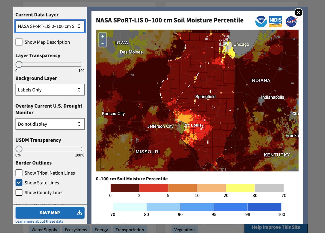
February 2026 OBS & Discussion
donsutherland1 replied to Stormlover74's topic in New York City Metro
It will turn briefly milder tomorrow to start the weekend. The temperature could approach or reach 50°. Colder air will return for Sunday through Tuesday. Monday could see the temperature top out near or even below freezing in New York City. After mid-week, a warming trend will commence. The second week of March could feature springlike readings. Long Island and coastal sections could be noticeably cooler than interior sections on account of a chilly onshore flow. Winter 2025-2026 will is on track to join Winters 1960-1961 and 1977-1978 as the only winters with two or more 10" snowstorms, a seasonal mean temperature of 32° or below and seasonal snowfall of 40.0" or above. The ENSO Region 1+2 anomaly was +1.2°C and the Region 3.4 anomaly was -0.1°C for the week centered around February 11. For the past six weeks, the ENSO Region 1+2 anomaly has averaged +0.37°C and the ENSO Region 3.4 anomaly has averaged -0.32°C. Neutral ENSO conditions have now developed. Neutral ENSO conditions will continue through at least mid-spring. The SOI was +13.35 today. The preliminary Arctic Oscillation (AO) was -0.344 today. Based on sensitivity analysis applied to the latest guidance, there is an implied near 100% probability that New York City will have a cooler than normal February (1991-2020 normal). February will likely finish with a mean temperature near 31.4° (4.5° below normal). Supplemental Information: The projected mean would be 3.9° below the 1981-2010 normal monthly value. February 2026 will likely be the coldest La Niña February since February 1934. Overall, Winter 2025-2026 is on track for a seasonal mean temperature of 31.9°. If a 32.0° or below seasonal mean temperature occurs, that would be the lowest winter mean temperature since Winter 2014-2015 when the mean temperature was 31.7°. Winter 2025-2026 would only become the fourth winter of the 21st century with a mean temperature of 32.0° or below. -
dt thinks winter is over ridge in east vortex stretches east west in canada.
-
I checked. They reported 0" for two days (2/21 and 2/22). Centerport observer reported 2" snow depth on the 22nd and Cutchogue reported 3". The old snow melts a lot slower than fresh stuff like we had on Wednesday. Even with these warm days having 8, 10 or 12 hours below freezing at night freezes up the pack and retards melting. It will accelerate as bare patches grown and more sun hits bare ground. I get why it seems to melt out so fast in the city (above freezing 24 hours), but the way snowpack disappears at times at ISP has puzzled me. They probably have a big open area to make observations, which is proper. My "open area" is level but gets a combo of sun and shade, which is the best I can do in a wooded neighborhood. That's definitely part of the difference, but not all of it as I still see snow in fields at times when the airports are 0. We hit 48 (47.8) here today. When I took a walk with my wife it felt like 70 in the sun despite the deep snow cover. Down to 35 now. If you drive down main Street in Smithtown, you might not think it has snowed. The town has been busy carting it all off to somewhere else.
-

2026-2027 El Nino
Stormchaserchuck1 replied to Stormchaserchuck1's topic in Weather Forecasting and Discussion
They were saying it was MJO related, but MJO is so tropospheric vs the Polar Stratosphere.. I think larger things are more correlating both is the argument. The anti-correlation is pretty strong though, -0.25 over the N. Pole is 62.5% chance at favoring cold ENSO vs warm ENSO, but that's probably because of not enough examples. It was actually pointed out last March that SSW would jump start El Nino, but the anti-correlation worked last March, as we had cold ENSO later this year. -
I think December 2020 was the storm Binghamton had 40 inches. Nothing to do with lake effect. It was that whole band from Binghamton up towards Albany. It just stayed there and snowed.