Search the Community
Showing results for tags 'blizzard'.
Found 9 results
-
Cold to start. Will storms return or mostly dry? Early spring? What will the groundhog say?
-
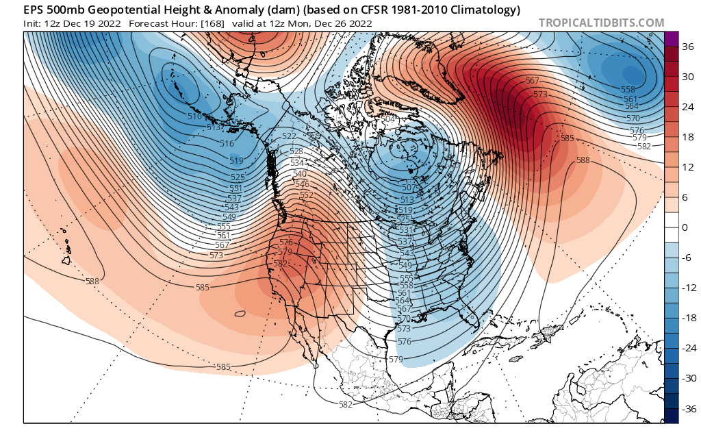
I know the models aren’t showing hits yet, but the 500s tell a different story. This look is REALLY close to something big for the shortwave diving down for the 27th threat after the big cutter. The western ridge axis is still quite far west, but it’s not offshore anymore. The NAO isn’t super negative but it is still negative which argues against a progressive solution (why I’m not buying the wave spacing issues, I’m thinking the northern energy will be much slower to enter the country). If that ridge pokes up a bit more and links up with the decaying block, I bet we will start seeing big solutions on the models. It’s really not far from doing so, it only needs a couple minor adjustments. This is a legitimate big dog Miller B nor’easter threat. That northern stream energy is quite powerful, and the teleconnections are in a transitory state.

-
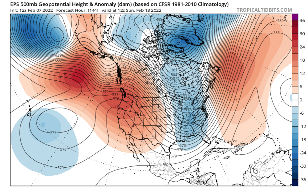
I have been watching this window on the models for a week now. The models showed the signal far out, but as we got closer they started burying the southern energy out west. However, the players on the field never left. Like the during the late January blizzard, we have a monster ridge out west with a deep trough in the east. The 12z eps doesn’t quite dig the energy enough to produce a big storm, but the following factors combined with continued favorable trends on the models tonight has me convinced there will be a big storm during the Feb 13-14th timeframe. Pros and cons: pros: 1. Arctic air, 540 line is as far south as the southeastern United States, and there is a strong high to the north. 2. Ridge axis is centered over Washington, which is VERY far west, and argues for a more western low 3. Atlantic ridging Cons: 1. Lack of North Atlantic blocking 2. Timing of the energy isn’t great I am convinced that the models are underestimating how much the northern energy will dig, and that the models will continue to trend more and more amplified. The stronger and farther west the northern energy digs, the more time the southern energy will have to get ahead of the northern energy, and the farther west the phase will happen. If the northern branch digs as much as I think it will, it will phase early enough that we will see a closed off strengthening upper low, which would slow the storm down and allow it to deepen rapidly. The track would also be farther west than what the models have right now, and would result in heavy snow and blizzard conditions in eastern mass. Despite the surface not reflecting it, models have trended more amplified with the western ridge, with a northern branch digging more and farther west.
-

March 12-14th Nor'easter Snow Map Final
USCAPEWEATHERAF posted a blog entry in Once a legend always a legend
Here is my third and final snow map for the Nor'easter tonight into Wednesday morning, 24 hour duration of snow, 24-30" in the jack pot zones likely, widespread 12-18" in all of eastern New England, snowfall rates may exceed 3-4"/hour, thundersnow potential is real, whiteout conditions will run rampant, high of around 35F and low around 28F on Tuesday for the Cape Cod area. Blizzard warnings are likely later this afternoon once the 12z package rolls through. Big potential for top three snowfall in Harwich, MA. My snowfall map is for New England only -
"Blizzard of 2018" "Storm of the Century"
USCAPEWEATHERAF posted a blog entry in Once a legend always a legend
Good evening folks, This is my latest blog entry and the first official entry on the potential Blizzard of 2018, or Storm of the Century potential on January 3-5th 2018. The first image is water vapor imagery taken as of this hour, it represents the different ebs and flows in our country. Also it currently has three disturbances that will impact our storm potential this week. The arctic disturbance is circled over NW Canada in a pink dot, the second disturbance is in red, the Pacific shortwave and then the third is in green the sub-tropical jet which is already providing moisture and rains in TX and LA this evening and will enter the Gulf of Mexico in the overnight into the early morning hours. This green dot disturbance will be the southern stream disturbance that gets carried northward as our storm develops by the next disturbance in the polar jet and the arctic jet. These will be our catalysts towards a destructive nor'easter, perhaps with the intensity we have never witnessed south of the benchmark in history. I believe the only way this system hits the benchmark head on as it tracks up the coastline is if the trough is more centered over or west of James Bay, Canada and recent runs have adjusted this direction. So I am now saying the track officially of the storm should be between 25-75 miles east of the 40/70 benchmark location as a sub 960mb low, stronger than the Superstorm of 93, stronger than the Blizzard of 2017, stronger than the Blizzard of 2016. 2015 and more. My second image is my snow map of impacts to the East Coast and potential snow accumulations of light. moderate and heavy. And I highlighted in red where on the coast can expect blizzard conditions. -
Ok, remember the last few posts have been about the past, well today's blog is about the future. IN the next 8-10 days periods of cold and rain are possible with a few mix events, but the main event looks to be in the Saturday/Sunday timeframe for New England storm system. Questions remain, but the gist of the future is that a potential coastal storm is looming. Currently models are not far enough south with the low, so it appears it will be a rain event, but with a Greenland block and PNA ridging, cold air looks strong and should push the upper level low to the southwest over time on the model forecasts. We will have to continue to monitor future runs. For now, potential exists for a snowstorm in New England.
-
Massive Nor'easter expected to dump 36" of snow
USCAPEWEATHERAF posted a blog entry in Once a legend always a legend
My latest snowfall map and Cape Cod could likely gust past 80mph tomorrow -
Massive Nor'easter expected to dump 36" of snow
USCAPEWEATHERAF posted a blog entry in Once a legend always a legend
My latest snowfall map and Cape Cod could likely gust past 80mph tomorrow -
Massive Nor'easter Forecast Snow Map and Wind Map
USCAPEWEATHERAF posted a blog entry in Once a legend always a legend
A major nor'easter/blizzard is imminent. Blizzard of 2017 is on its way. The northern piece of energy has made a US landfall over NW US at 18z yesterday afternoon or evening and this is the energy that we have been waiting for a sampling of and now that we got models adjusted stronger with the southern vort max and northern vort max. Now there are three jet streams involved. The northern jet stream (AKA Arctic jet stream), southern stream (Pacific Jet) and the sub-tropical jet which situates over the gulf of Mexico, providing the system with a GOM low pressure center and moisture. Ok lets get down to the gist of the models. Models are somewhat different still in their handling of QPF, and storm track as well as intensity and they differ on degree of phasing between all three jet streams. The models have trended stronger with the pacific jet stream energy disturbance over the northern Plains now. this swings southeastward, and depending upon how far south it gets will help determine which model is correct as well as which storm track is correct. On water vapor imagery, one can see a distinct area of vorticity spinning in the atmosphere, this is our southern stream (Pacific jet ) disturbance. With its own moisture source from the Pacific and the Rocky Mountains not doing much to stop the moisture from entraining into the Northern PLains is dumping a good to decent amount of snowfall over the northern Plains towards Detroit, MI. this energy is being forced to the southeast by a large arctic jet gyre or upper level low pressure system diving southward into the Great Lakes tomorrow morning. This trough carries our southern stream disturbance up the east Coast combining with the GULF OF MEXICO energy and low pressure center combined to bring a singular coastal low pressure center that will be rapidly deepening as it head north-northeastward up the East Coast. This earlier phase now expected to happen by most guidance models, is actually allowing the system to track more offshore rather than up the NYC harbor. Benchmark track or Cape Cod track is the final question that needs to be answered. I am going with a forecast mix of the GFS/EURO/NAM models. Using the NAM for QPF output based upon the GFS progressiveness bias in these circumstances in which the storm is allowed to slow down due to the phasing of jets in which the large upper level low phases into the southern stream disturbance and slows it down before departing. I think the low will move from the benchmark to about just east of ACK and CHH producing a mix of rain/snow for coastal Cape Cod and Islands therefore I have Nantucket in the 0-4" range and Harwich to Bourne in the 8-12" range, Chatham will likely see less with 4-8" of snow. the GFS produces a ton of moisture but it falls over the ocean, this is bound to move over land, but where will help determine who gets how much, for now I will leave the 18-24" isolated 30" amounts in banding in the position it is in now. Temperatures tonight will be in the low teens once again. Tomorrow afternoon highs will be near 30F and lows will be near 20F, I don't see how a low 40s ocean warms an arctic air mass with a northerly component to the wind field over Cape Cod, but regardless my forecast carries a mix over Cape Cod therefore only about 8-12" will fall before the changeover. Thunder snows and intense snowfall rates will be likely before the changeover occurs if it does at all. the GFS is all snow except for about a changeover briefly of about .2" of QPF as rain. That shouldn't matter much. the other aspect to this storm is the wind damage and blizzard conditions. I think blizzard conditions are likely even for Cape Cod and the NWS will likely issue a blizzard warning for us instead of a winter storm warning. Hurricane force winds are likely for Cape Cod, Cape Ann and Nantucket and all along the NH and Maine immediate coastline. Also Downeast ME sees only a few inches given that the low tracks west of them bringing in warm air off the ocean from the southeast. Thank you