All Activity
- Past hour
-
1/27 06z QPF summary ICON: GFS: GGEM: UKMET: GEFS: GFS AI AIGFS: EURO: AIFS: EPS:
-

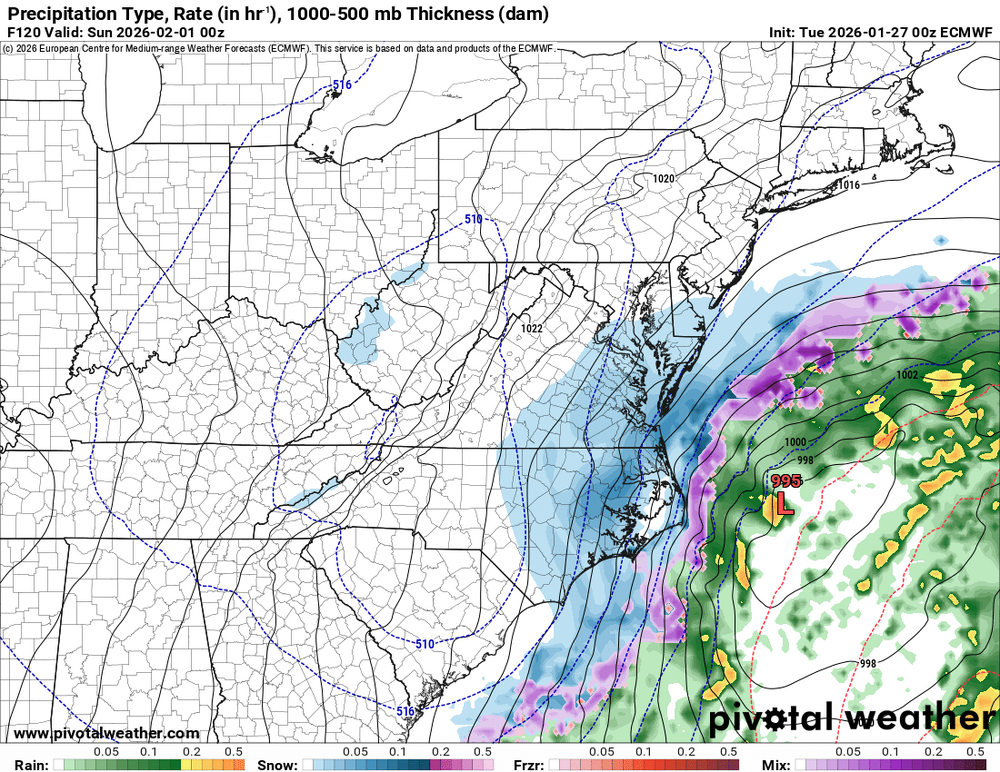
Possible coastal storm centered on Feb 1 2026.
Ginx snewx replied to Typhoon Tip's topic in New England
Tip started the thread. Death Knoll. (Insert Psycho babble response) j/k John -
22" after a big day 2
-

January 2026 Medium/Long Range Discussion
Snowciopathic Snow Bro replied to snowfan's topic in Mid Atlantic
Grocery stores are quiet around here because nobody can get out of their unplowed neighborhoods to get to them, lmao. VDOT, where art thou? -
I think today is a day where each model can jump 200-250 miles in either direction. Once within 72-96 hours that’s much less likely as you get 50-100 mile moves and then the typical 25-50 shift within 24-48 hours
-
I’m extrapolating a big nor’easter. Somewhere.
-

Possible coastal storm centered on Feb 1 2026.
Typhoon Tip replied to Typhoon Tip's topic in New England
I think we got about 2 ...maybe 3 cycles remaining. After that, it's probably a consensus go or no go -
Snowed on and off much of the day yesterday... picked up around 2" of pure fluff. Snowing again lightly now with 1-3" in the forecast.
-
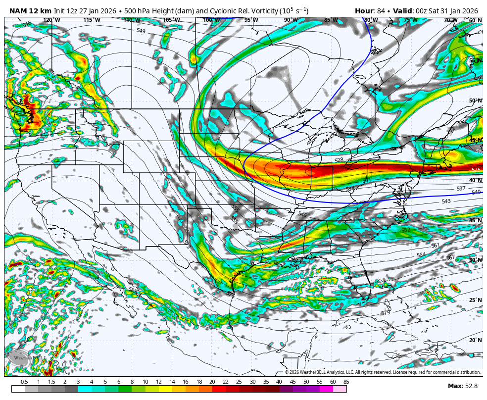
I know its the 84hr NAM but the uppers look much for like the EURO-AI then the EURO.
-
WB 12Z 12K NAM at range:


-
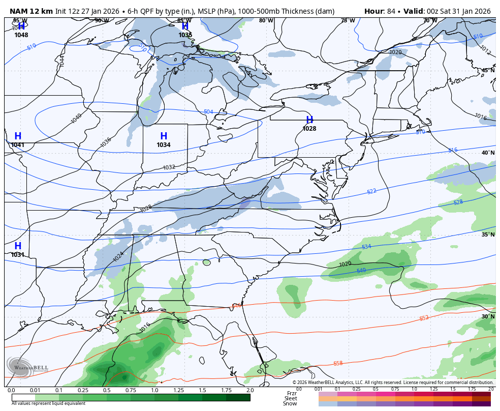
Timing is everything with this weekend's system. The Euro phases the upper low later and farther east, leaving the mountains with cold air aloft but limited divergence and moisture. The GFS phases earlier, allowing stronger upper-level divergence to overlap deeper moisture and throw precip back into the Appalachians.
.thumb.png.f17dd585b2d225e04aa7a57040fc60cd.png)
-
Going out to sea is more a product of this closing off too early than issues with the trough orientation.
-
Possible coastal storm centered on Feb 1 2026.
Ginx snewx replied to Typhoon Tip's topic in New England
I was responding to Donnie 2 states. -
The key points to remember for today IMO 1. the key piece of energy that will generate the trough lalter this week is still far north in Canada and there is sparse sampling up there. 2. The trough down south later this week has to take on a negative tilt sooner than later and further west for this storm to get close enough to the coast to give us a major storm. If it waits to go negative further east the storm will ride up the coast further east. 3. The reason the trough has to go negative earlier and further west is because the upward motion in the atmosphere is on the northeastern flank of the trough promotes heavier precip and this will be centered over the metro if the storm is close to the coast and out to sea if it goes negative to late.
-

The “I bring the mojo” Jan 30-Feb 1 potential winter storm
ADB83 replied to lilj4425's topic in Southeastern States
Well, at least the possibility of it going north is pretty much dead lol. . -

E PA/NJ/DE Winter 2025-26 Obs/Discussion
Violentweatherfan replied to LVblizzard's topic in Philadelphia Region
You want zero interaction and or have the kicker late or non existent -
It might even miss them, per the euro
-
Sure. I think a scraper is most likely. Or just a total miss
-

Possible coastal storm centered on Feb 1 2026.
WinterWolf replied to Typhoon Tip's topic in New England
No doubt it’s a great looking set up…at least as it currently stands, but we all know these little things change as the said timeframe approaches, and that’s where the uncertainty lies. Hopefully they change slightly in our favor. -
The ridge axis so far west gives me more hope this won’t slip out to sea. It’s in a place where honestly it’s better for the Apps. If it was say over the Dakotas that would be more of a problem. But a couple of tweaks which are very doable at this stage and we’re back to monster solutions.
-
8.5° Since I got a PWS in 2013, the lowest temperature I have recorded was 3.6°. Perhaps that gets dethroned this week.
-

January 24-26: Miracle or Mirage OBS Thread!
nw baltimore wx replied to Jebman's topic in Mid Atlantic
That’s ridiculous, but we shouldn’t need laws to do things like return your shopping cart and clean your car of dangerous debris. -
E PA/NJ/DE Winter 2025-26 Obs/Discussion
Violentweatherfan replied to LVblizzard's topic in Philadelphia Region
From past experiences once there is a kicker its pretty much game over -
Was just coming here to post this! Big changes from even just a few days ago


.png.b342977ca471a322d61332d123effc23.png)


