All Activity
- Past hour
-
.thumb.png.4150b06c63a21f61052e47a612bf1818.png)
Wednesday Feb 18 Mixed event. NoP refresher?
HIPPYVALLEY replied to HoarfrostHubb's topic in New England
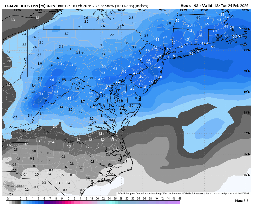
If it breaks right, it’ll be a 40 - 50 mile wide swath of advisory snows. -
what exactly am i looking at here?
-
There’s probably no one watching other than me, but Italy women curling team demonstrating great sportsmanship after the US accidentally hit a stone with a broom.
-

Winter cancelled/uncancelled banter 25/26
WeatherGeek2025 replied to Rjay's topic in New York City Metro
Very excited for this weekend, Heck Friday night we could get a surprise snow event especially north and west of the city. Long nights ahead I wish I was off from work so I can stay up and wait for the euro and euro ai runs! -
bro don't tempt it
-
That purple pants tent is right over @stormtracker house.
-
We have better consensus across the ensembles, and if they hold, the ops will follow in the next couple days. Then we have something legit to track!
-

Wednesday Feb 18 Mixed event. NoP refresher?
ineedsnow replied to HoarfrostHubb's topic in New England
18z HRRR looks great for here at hr48 but that doesnt.mean much -
Except aren’t we in 2-3 until maybe right when the storm hits?
-

February 2026 OBS & Discussion
CPcantmeasuresnow replied to Stormlover74's topic in New York City Metro
Very true, that's why you can't hate the guy. -

Late February/Early March 2026 Mid-Long Range
NorthArlington101 replied to WxUSAF's topic in Mid Atlantic
Anyone still like the WeatherNext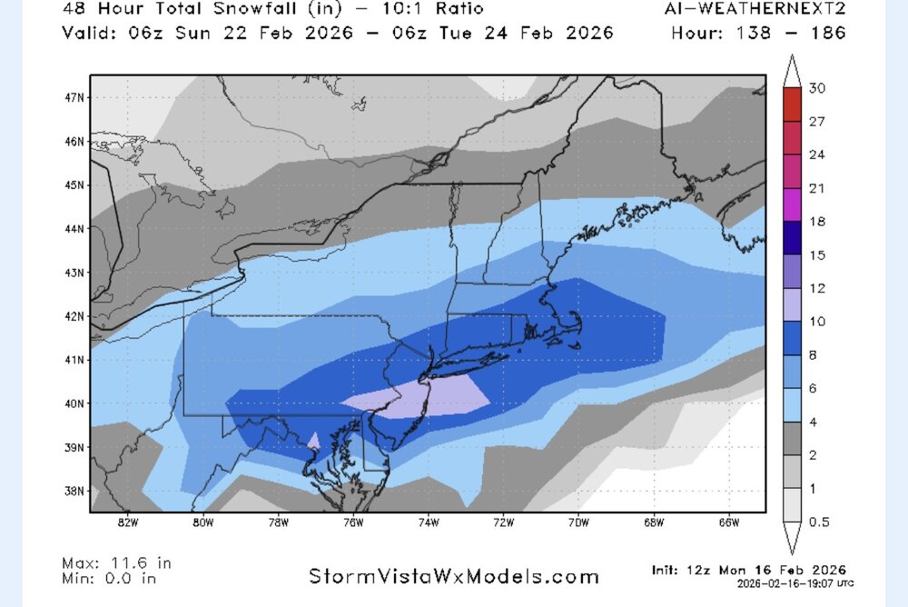
-
Take this ensemble as a MAJOR grain of salt, but FWIW

-
Dusting here.
-
Dusting here that melted quickly.
-
This is very acceptable for a mean at this range. GEFS and CMC ens are decent too. Pretty strong signal.
-

February 2026 OBS & Discussion
hudsonvalley21 replied to Stormlover74's topic in New York City Metro
Agree, possibly even waiting till 00z Thursday. Have to get more sampling in the next few model runs and the players on the field. -

2025-2026 ENSO
michsnowfreak replied to 40/70 Benchmark's topic in Weather Forecasting and Discussion
There is definitely some merit to the Mar/Apr correlation of warm/cool or cool/warm. Its certainly not a guarantee. But in those few years where March is warm and nearly snowless, you can bet April will see accumulating snow. -
Looks like we make it through yet another February without a trackable threat. I know RDU-east got that February storm last year but there have been so many blanks recently that it’s really becoming a spring month. This is most on the forums snowiest climo month and now it’s just a segway into official spring.
-
Hagerstown, MD had a week in January 1961 without snow cover. Martinsburg, WV had 6 days, from 1/8 through 1/13 with bare ground. Otherwise, snow was on the ground at both sites from 12/10 to 2/23.
-
-
There is an interesting relative max in the PNA that takes place 23-26th; it's nested in the midst of an ongoing submerged PNA. It's like a sub-surface sea mount with a buoy blinker to warn passing ships. Ha There's some other everyday reasons to suspect less coastal crawling big dawg solutions are favored, but that bold aspect about the zonal/W-E is big correction lean that's a pretty big one. Pig solutions at this D7-10 range also tend to lose amplitude as they are relayed inward in time. That's more than less an ongoing operational weather forecasting application aspect. But combining that with the former ... I tell you what, it would be fun ironic if this one fought off all those reason and worked out for the better. There is still the relative PNA spike.
-
2025-2026 ENSO
michsnowfreak replied to 40/70 Benchmark's topic in Weather Forecasting and Discussion
I just dont get into it. Been a great winter for the cold/snowcover crowd in the Great Lakes, so while most of the public is ready for a break, I hate the sun and melting snow. I am going to the U.P. later this week though. -
(002).thumb.png.6e3d9d46bca5fe41aab7a74871dd8af8.png)
E PA/NJ/DE Winter 2025-26 Obs/Discussion
ChescoWx replied to LVblizzard's topic in Philadelphia Region
31st consecutive day with snow cover here in Chesco - tied for the 12th longest stretch since 1894 and 17th overall.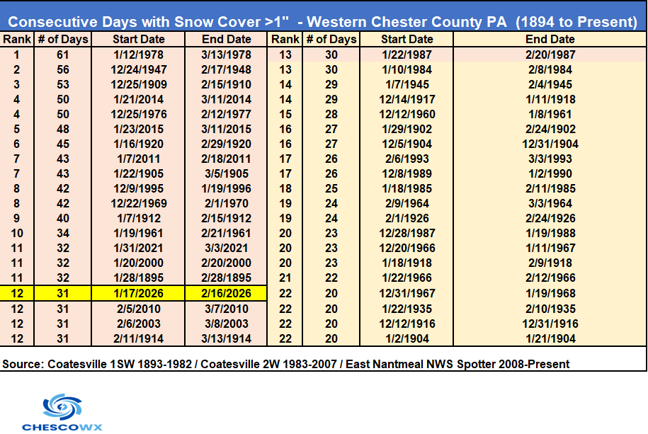
-
Dude I’m watching it too. 130+m jumps are wild. Cannot even fathom it
-
They issued because snow thats been on the ground all winter traps pollutants like road salt/exhaust/etc and its melting without aid of any wind and instead a temperature inversion, so those pollutants are hanging in the air instead of mixed out from the wind.