All Activity
- Past hour
-

Southern Crippler - Get well soon Jimbo Storm Obs
kvegas-wx replied to BooneWX's topic in Southeastern States
We're getting cloud to cloud results here. Pingers one minute, nothing the next. Need better rates. -
Not a fan of this downgrade.
-
Memo to snow gods ... don't need all my residuals tomorrow ... but do what you have to do!!! (my airport predictions for 1/24-26 total DCA 5.5, IAD 8.2, BWI 8.8, RIC 3.7. ... I need about twice those amounts for the contest but let's be optimistic and say there will be more to come) Would be happy to get it all in this storm though.
-

1/24-1/25 Major Winter Storm - S. IL, IN, and OH
mimillman replied to A-L-E-K's topic in Lakes/Ohio Valley
Tiny flakes in Logan square -

Jan 24-26 Weekend Snow and Sleetfest Model Thread Part Tres
stormtracker replied to H2O's topic in Mid Atlantic
GFS has begun...I'll just post relevant panels as I get them -

1/24-1/25 Major Winter Storm - S. IL, IN, and OH
Jackstraw replied to A-L-E-K's topic in Lakes/Ohio Valley
I can here the clang of swords overhead as the demon dry air and the light of flakes clash! -

Jan 24-26 Weekend Snow and Sleetfest Model Thread Part Tres
jayyy replied to H2O's topic in Mid Atlantic
Orange County NY -
 Thank you for sharing - can you show me a visual if you’re able? It’s ok if not.
 -
 Not looking forward to the next few hours for our county. .
 -

Central PA Winter 25/26 Discussion and Obs
mahantango#1 replied to MAG5035's topic in Upstate New York/Pennsylvania
We're probably less than 12 hours from the onset of our first major snowstorm in years. I hope you all enjoy no matter the outcome -
Jan 24-26 Weekend Snow and Sleetfest Model Thread Part Tres
stormtracker replied to H2O's topic in Mid Atlantic
Don't know if it's reaching the ground, but there's a good slug of precip just NW of RIC https://weather.cod.edu/satrad/nexrad/?parms=LWX-N0B-1-24-100-usa-rad -

Richmond Metro/Hampton Roads Area Discussion
eaglesin2011 replied to RIC Airport's topic in Mid Atlantic
Yes, Eagles fan .. Originally from up that way…. Still being shut out where I am.. What a under-performing storm so far lol -
Just a bit of a moisture fetch: https://www.star.nesdis.noaa.gov/GOES/conus_band.php?sat=G19&band=08&length=24&dim=undefined
-

January 25/26 Jimbo Back Surgery Storm
Tyler Penland replied to Jimbo!'s topic in Southeastern States
Snowing solid in Blowing Rock right now. Got the ground/parking lot covered in about 15 minutes. -

Jan 24-26 Weekend Snow and Sleetfest Model Thread Part Tres
Maestrobjwa replied to H2O's topic in Mid Atlantic
According to more knowledgeable folks in here...it appears so. So given that--that's another reason to be skeptical of the QPF. Nowcasting may bear that out... -

“Cory’s in LA! Let’s MECS!” Jan. 24-26 Disco
WinterWolf replied to TheSnowman's topic in New England
Everybody in SNE gonna do great….let’s savor every minute of it. It’s gonna rock tomorrow boys. -

Central PA Winter 25/26 Discussion and Obs
WmsptWx replied to MAG5035's topic in Upstate New York/Pennsylvania
I mean, if the NAM scores a win here, they really need to look at halting decommission and supplementing it to where it's more than a short range specialist. -
Soon as I’m able, I will. It’s from the auto immunes. RA does this to me with major weather, but it usually isn’t this bad. Thank you for caring enough to urge me to go. You’re definitely right.
-

MO/KS/AR/OK 2025-2026 Winter Discussion
stormdragonwx replied to stormdragonwx's topic in Central/Western States
TSA is being way too optimistic trying to salvage their forecast. I think they are just looking at the GFS which is way overdone. -
 Both those stations winds are still out of the NW
 -

1/24-1/25 Major Winter Storm - S. IL, IN, and OH
sbnwx85 replied to A-L-E-K's topic in Lakes/Ohio Valley
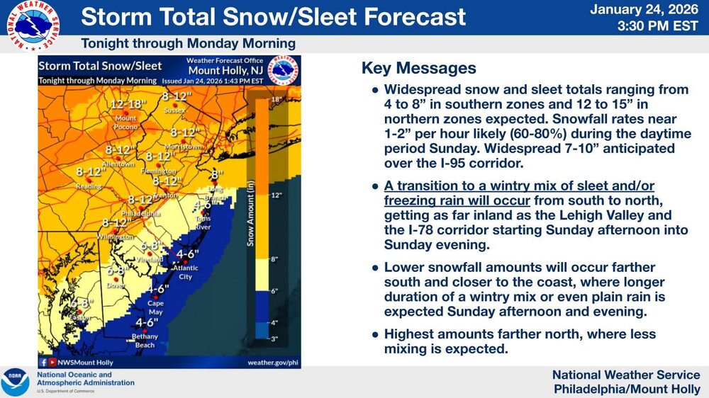
I feel seen DISCUSSION... Issued at 224 PM EST Sat Jan 24 2026 Overall, no significant changes to the incoming winter storm. A wintry weekend is underway or imminent for much of the US. Low pressure over the TX/LA Gulf Coast slowly lifts north this evening with a modest precipitation shield extending into the mid- Mississippi valley where Arctic High Pressure has a grip over the Midwest. This high pressure limits poleward moisture transport this evening with its strong subsidence and bone-dry air mass (dew points in the 10s-to-teens below-zero). Forecast soundings do show saturation occuring prior to midnight ET for those along and south of US 24 allowing for about 1-2" by daybreak Sunday; armchair meteorologists may scoff Sunday morning about the lack of snow but more is on the way. Our primary period of prolonged, steady snowfall is during the day Sunday and tapering off after sunset. This is when a second, more potent low currently digging in over the Baja of California lifts northeast through the Tennessee River Valley. By this time, high pressure will have shifted northeast allowing for improved moisture profile locally, but still cannot rule out being "robbed" of some moisture transport with such a large precipitation shield across the S Southeast US. The 12z suite of forecast guidance generally stayed close to the existing forecast. There were some northward shifts in CAMs (as well as the NAM). Balancing the dry air mass, subtle northward shift of some guidance and reducing snow ratios a touch, we`ve generally held course with this afternoon`s forecast package. In coordination with neighboring offices, we did reduce the inherited 20:1 snow ratios (now capped at (17:1); likely over- boosted by the very cold air mass. Indeed, the 15k FT deep dendritic growth zone is impressive, but overall forcing in the column is modest as revealed by time-height cross sections. Nonetheless, a fluffy snow and a brief period 1" per hour rates. These rates are most likely around sunrise Sunday morning as an area of mid-level frontogenesis passes overhead. Wind gusts of 15 to 25 mph will result in areas of blowing and drifting snow, with easterly wind at the start of the evening "backing" (counter-clockwise) to become westerly by the snow`s end. A single band of lake effect develops Sunday night as this surface low becomes centered off the New England coast. The band tracks from the western Lake Michigan shore to the east which will limit residence time but 1" per hour rates are expected as the band swings through. Depending on its residence time for the Monday morning commute, additional winter weather headlines may be needed for Michiana. -
Might mean it will be through the area faster.
-

Central PA Winter 25/26 Discussion and Obs
Jns2183 replied to MAG5035's topic in Upstate New York/Pennsylvania
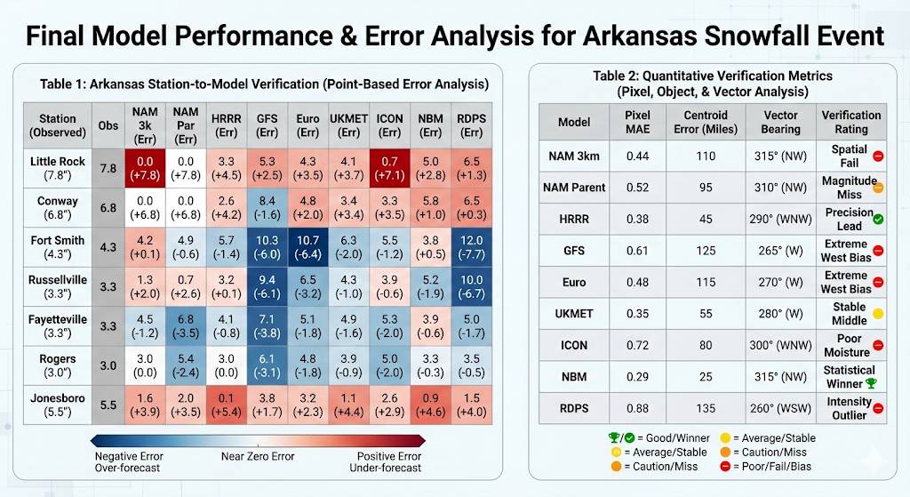
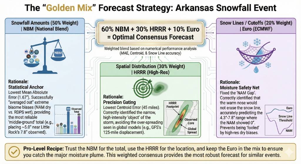
Lessons from Arkansas below. Later I'll do an update for round two and look at Kentucky/Missouri, Ohio Trust the NBM for the most likely total. * Use the HRRR to define exactly where the heavy bands will set up (the "where"). * Keep the Euro in the mix to ensure you aren't being "fooled" by a high-res model (like the NAM) that might be missing a major moisture plume. Sent from my SM-S731U using Tapatalk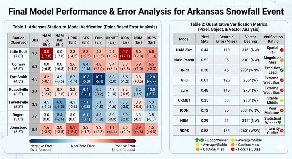

-
East Tennessee has dealt with very dry air near the surface all morning. It’s finally beginning to clear out. Mid to high levels have had moisture for a while now. .
-

January 24-26: Miracle or Mirage JV/Banter Thread!
Snowciopathic Snow Bro replied to SnowenOutThere's topic in Mid Atlantic
Ice water for me right now. Simulating ZR, but the changeover to Tito's on the rocks occurs around 02z. Now, the question is once you've consumed half of your beverage, is the glass half full or half empty?