All Activity
- Past hour
-
JFK Airport and Newark saw their lowest high temperatures two days after an 80° or above low. JFK Airport: 72° (old record: 76°, July 23, 2019) Newark: 72° (old record: 76°, July 23, 2019) Temperatures will return to the lower 80s for tomorrow and then middle and perhaps upper 80s for the remainder of June. Newark could be near or just above 90° on several days. In addition, there will be a risk of a shower or thundershower during the weekend. Excessive heat does not appear likely to return through at least the first week of July. The ENSO Region 1+2 anomaly was +1.0°C and the Region 3.4 anomaly was 0.2°C for the week centered around June 18. For the past six weeks, the ENSO Region 1+2 anomaly has averaged +0.47°C and the ENSO Region 3.4 anomaly has averaged -0.03°C. Neutral ENSO conditions will likely continue through at least late summer. The SOI was +12.65 yesterday. The preliminary Arctic Oscillation (AO) was +1.013 today. Based on sensitivity analysis applied to the latest guidance, there is an implied 99% probability that New York City will have a warmer than normal June (1991-2020 normal). June will likely finish with a mean temperature near 73.2° (1.2° above normal).
-
RRFS is also on Pivotal but not on Tropical Tidbits yet…
-
-
Is HREF in production? I thought the SREF is what is considered official, while the HREF is considered experimental/testing... NEVERMIND - @OceanStWx answered the questions :-)
-
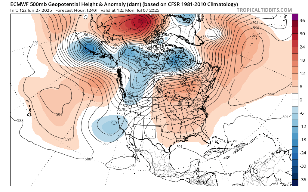
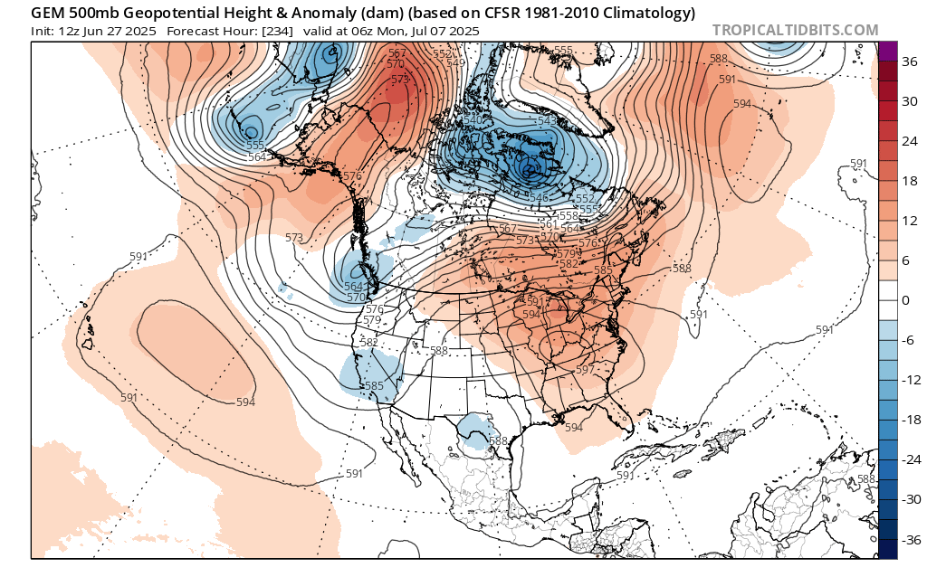
Yeah, I just saw that. The last few model runs really dig another trough out West. So more potential for another very strong heat dome. Maybe this one will line up a little further west rather than directly over the Northeast. So perhaps pieces of major heat coming east from time to time. In any event, there was a big shift to warmer beginning with the 0z runs.

-

Chester County PA - Analytical Battle of Actual vs. Altered Climate Data
bdgwx replied to ChescoWx's topic in Climate Change
And at the global level the net effect of all adjustments actually reduces the overall warming trend. [Haufather 2017] -
Could this be our CC induced summer from hell? Maybe
-
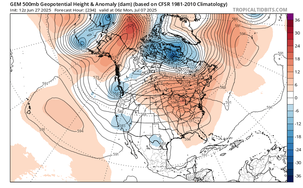
The Euro op has 600 DM ridge center in MO/KS at H 288
-
Finally getting some cooling in the past couple of months after that record run for 2 years. CERES 12-month rolling average appears to have bottomed in Nov (March numbers are coming back up and it should recover more substantially when May numbers are out). Temp tends to lag this by quite a bit (up to a year) and cool ENSO could also help throw a lid on things through Q1/Q2 next year, but after that, we're free to start heading back up again barring (yet another) cool-neutral or Nina year. These next couple of years may see us slide under the 1.5 threshold (on all datasets) for the last time. I get the feeling we won't be seeing it again after the next spike, though.
-
High so far here is 69
-
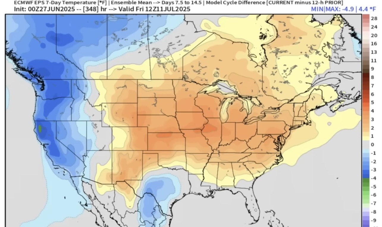
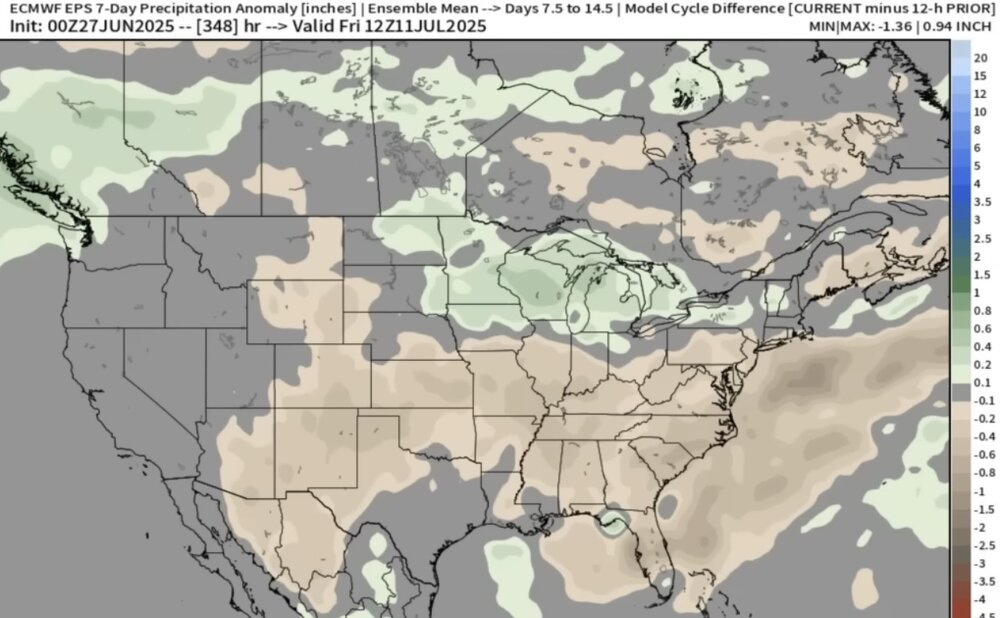
Unfortunately, the 12z guidance wants to reload another 594+ ridge in about 10 days. I was hoping we could get a break from the 100° heat. But it looks like the pattern may have other ideas. Past instances of 103° to 105° heat didn’t usually have such a quick follow up of the ridge rebuilding. So maybe we can keep it more in the 95° to 100° range in early to mid-July rather than pushing 105° again. But who knows for sure with this climate.

-
Btw, I think the unusual convective behavior last night was in part due to the extreme (and highly stratified) Bay water temps imparting a lot of latent and sensible heat flux to the atmosphere when that back door cold front and aggregate outflow came in to help trigger it after sunset (along with some radiative cooling at the anvil level post sunset). Bay temps at 1.5m were running at 86-90F and probably quite a bit hotter in the top 1-2 ft. Storms did their job last night and temps are back down to 82-83F today.
- Today
-
The sensor is "in-spec". But it does tend to run 1-2 degrees warmer than it should and about a degree too soft on dewpoints. (This is with me various handhelds against the main ASOS sensor). But it's closer than I initially thought when I started to suspect it was too warm. It was at least 102-103 here on Wednesday. A few factors that helped: Evapotranspiration effects here tend to peter out faster than nearby stations because of lower tree cover and a lot of grass that tends to cure and brown quickly under very hot and dry conditions. That happened in just 3 days here this week. Note that during the peak temp, dewpoints dropped rapidly, indicating drier air from aloft mixing down as sensible heat flux increased relative to latent heat. There was no gradient flow and nearly perfectly barotropic conditions with a lot of subsidence and very strong vertical mixing. This prevented a sea breeze from properly forming on time and heavily stratified the surrounding waters. I was in that water in Pt. Lookout on Monday and the top layer was easily 10F+ warmer than 1-2m down. Lack of any appreciable mixing meant that the skin temp of the water surface was very hot and that helped disrupt/delay a sea breeze circulation in this locale.
-
Looking at the EPS/GEFS/GEPS I’m starting to think there is going to be a risk for another major heat wave and big ridge moving into the east around mid-July
-
Hopefully it shows the coastal front going to ORH with a 1040 high north of CAR.
-
the nam was pretty often the first model to sniff out that the mid-levels are going to torch way inland... I dunno, that's my impression at least, others would be better qualified.
-
98.4, HI 105. Considerably hotter than yesterday here
-
Not great, Bob. That's going to be my biggest loss with the NAM.
-
I actually think the HRRR is decent inside 24 hrs. I've found it useful for trends etc. Maybe it doesn't nail the placement of cells perfectly, but overall I like it. The other night for example...it had these random downpours develop after midnight. It was strange to see at that time of night from a cold front sliding south. Sure enough, they popped especially just south of me.
-
Pretty unrelenting run of heat. I’m getting older and I’m sure more sensitive to it but I don’t have AC and this is the most difficult stretch of heat I’ve experienced in my 40 years. Just no real relief outside of a pop up storm
-
The RRFS is on weatherbell for sure. It does OK from what I can see. My bigger question is how it does in the cold season - cold air damming, mesoscale banding, etc.
-
Yeah @Matthew70 more flooding is a verified trend. Makes sense with greater average Theta-E in the Atmo warmer and with more water vapor. Guess the rest of this discussion is over in climate wars, lol! Climate Change in the General thread section. I remember Alaska had a hot week. That's why social media is not great for breaking weather. Love seeing week old warnings. Even phones give week old stories in notifications. Like yeah, I already know I missed the Northern Lights last week! Anyway let's talk July. We get more t-storms through the weekend into Tuesday when a weak Fropa is forecast. Per usual in July the one day of nice high press evolves into hot high press. Might be hot again starting around the 4th of July, but not as nuts as this week. Indeed, another hot spell (trying to avoid heat wave language) is forecast around the July 4-6 weekend into the following week. Atmo appears to be working off this heat wave still, with a lingering ridge sloshing around Texas and the Mid-South early next week. If all goes well the rest of July looks closer to seasonable. Highs around 90 instead of into the 90s would feel great now. Most teleconnections and GWO / GLAMM etc want to trend to heat North and West with normal Southeast. Euro weeklies does less Great Lakes ridgy which would better ensure reasonable temps here. CFS connects 'em which leaves us open to heat spikes. We've had years before that got hot early and then went near normal. 2012 comes to mind as one that truly went normal later in summer, vs lingering slight AN. We'll hope for the 2012 version.
-
65F & overcast here in the Berks. I'm getting ready to put the boat in the lake this weekend, but it's not looking good wx wise up here. 71 back in HPN.
-
Clearing out some of the computing resources also potentially leads to more model runs. There are ways to get more data out of this.
-
Got another 30C+ day, now 31C humidex 35. The wild swings in temps continue. Thurs had a minor windchill after all this heat and then 20 hours later we're back 4pm: 33C/90F on my station, humidex of 41 or so. 24 hr ago it was 16C/61F with a chill!