All Activity
- Past hour
-
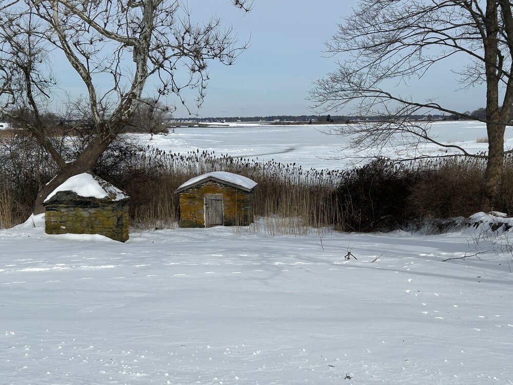
Deep winter in Colt State Park in Bristol.
-

Possible coastal storm centered on Feb 1 2026.
CoastalWx replied to Typhoon Tip's topic in New England
2.5” Gloucester. 2-3” at my parents already. So close. -

Jan 30th-February 1st 2026 Arctic Blast/ULL Snow OBS Thread.
Knoxtron replied to John1122's topic in Tennessee Valley
-
His quoting my post wasn't about you unless you're running two different accounts...
-
You guys deserved a better storm. Even in my downslope area I'm surrounded by 6-10" plus in all directions and I got a little over 5. Grateful but not a memorable nor historic storm here. The wind last night was more memorable than the snow honestly. It was gusting over 50.
-
yeah, that's the only point I was trying to make... I think it's useful because there seems to be some debate about the cold aspect this year? heh, I don't ultimately care that much just sayn'
-
It's not set in stone... And it's NOT going to get Mild and Warm.just look what happened the last time the models showed this ( twice I think ) it went back to the cold pattern. Of course this won't last forever as spring has to come, but we still have plenty of time.. maybe a brief milder period.
-

January 30th- Feb 1st ULL and coastal storm obs
WXNewton replied to JoshM's topic in Southeastern States
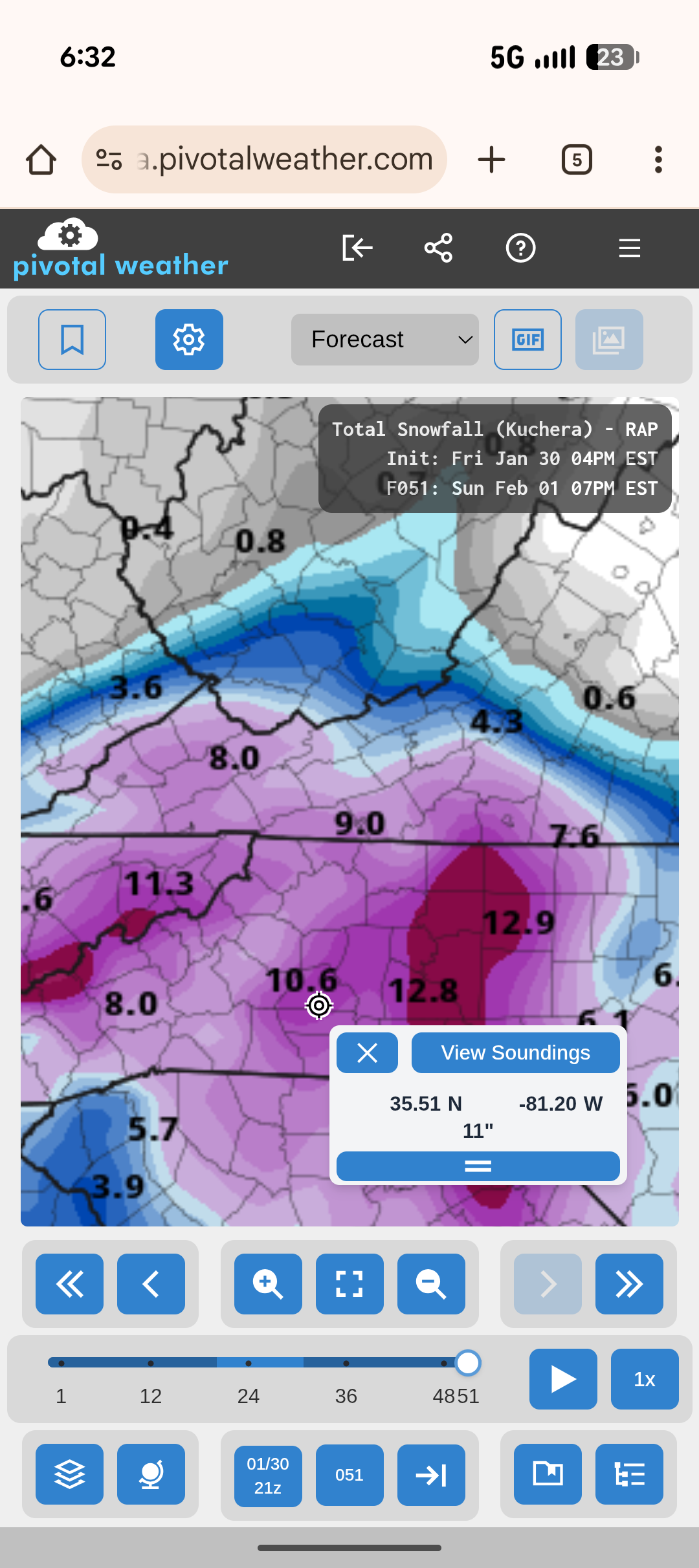
The 4 p.m. RAP run from Friday did pretty well with totals back in the central and western parts of the state. Nailed the heavier area from CLT towards Greensboro.
-
I’ve been a regular reader of this blog and its predecessors for about 20 years. I seldom post because, in general, I don’t think I have the expertise to meaningfully contribute. I’ve started occasionally posting recently because I think it is important to note the truly exceptional warmth and lack of snow in significant parts of the West this season, where longstanding records are absolutely being smashed. It is a big deal and should be part of the dialogue alongside the discussion about a kind of chilly and snowy season in parts of the East (only) that’s not historically noteworthy. Just my opinion though.
-
Anyone else kinda shocked by the torching? I may hit 40 at the pace I’m moving
-
No I wasn’t and I posted multiple times in the other thread how happy I was for everyone else. I tore the cliff diving thread up, that’s what it’s for
-
2022 was 11 inches here even with sleet tainted in. Moisture still remains a problem here and I wonder if we are heading towards a dry spring. The wind last night was insane here. I'm truly grateful we didn't lose power.
-

January 30th- Feb 1st ULL and coastal storm obs
eyewall replied to JoshM's topic in Southeastern States
A friend of mine in Peletier, NC measured 20 inches. -
It’s melting.
-
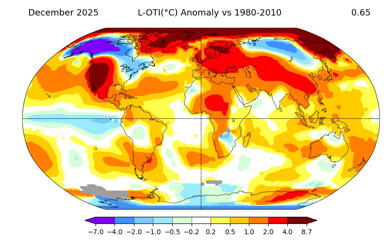
Here's the 1980-2010 for shits n gigs
-
Historic storm for them especially coastal Carolinas. This could’ve been a top 5 storm possibly if it consolidated and turned the corner. I’d just love it if we stopped flipping between suppressed crap to SWFE/cutter. We’ve been lucky this winter with storm types that don’t usually favor heavy snow here.
-
I agree with you…just was pointing out that those maps (esp near us due to regional climate variability) will make it look a lot warmer than our more conventional departures would suggest given the ‘51-80 base period….january was def more -AO so prob larger mid-latitude bands of colder airmass.
-

Central PA Winter 25/26 Discussion and Obs
Voyager replied to MAG5035's topic in Upstate New York/Pennsylvania
Lol... I did actually fit under it when I was driving the buses. -

2025-2026 Fall/Winter Mountain Thread
Sw NC weather replied to Buckethead's topic in Southeastern States
Congrats everyone. This sure was a fun storm. Bottomed out at -1.2 this morning and just a hair below 7” of snow. -
Central PA Banter (Banter Less?) Thread
Voyager replied to Itstrainingtime's topic in Upstate New York/Pennsylvania
In reality, I don't want to divorce my wife. If I did, I would have stayed in AZ after my mom passed away. The only reason it comes up is because it's the only way to move from PA. I mentioned the other day how if the place I was working at when I was caring for my mom wouldn't have closed, I'd have had a hard time leaving it as it was one of the best I'd ever had. Her response? Well then, we'd be divorced right now. So you see, it's actually her refusal to move that brings it into the discussion. -
Okay... well, relative to that product scope, then. I still suggest the mid latitude are colder in January than December.
-
NW flow setups like that only work in areas from ATL on south if the upper level feature organizes much earlier across the TN Valley. This one developed too late and was too far north. The March 1980 storm was similar but the upper level low and trof developed much earlier and tracked more south.
-

February 2026 Medium/ Long Range Discussion: Buckle Up!
dailylurker replied to Weather Will's topic in Mid Atlantic
I did that the first week of January on the Tug. 100" in 4 days thank you lol. I'm hunting wintery conditions to last as long as possible. We do warm a safe roads 99.9% of the year. -
February 1 1931: A 'heat wave' develops across southern Minnesota. St. Peter hits 60. For Sunday, February 1, 2026 1893 - Thunder and lightning accompanied sleet and snow at Saint Louis MO during the evening hours, even though the temperature was just 13 degrees above zero. (The Weather Channel) 1951 - The greatest ice storm of record in the U.S. produced glaze up to four inches thick from Texas to Pennsylvania causing twenty-five deaths, 500 serious injuries, and 100 million dollars damage. Tennessee was hardest hit by the storm. Communications and utilities were interrupted for a week to ten days. (David Ludlum) 1951 - The temperature at Taylor Park Dam plunged to 60 degrees below zero, a record for the state of Colorado. (Sandra and TI Richard Sanders - 1987) 1985 - Snow, sleet and ice glazed southern Tennessee and northern sections of Louisiana, Mississippi and Alabama. The winter storm produced up to eleven inches of sleet and ice in Lauderdale County AL, one of the worst storms of record for the state. All streets in Florence AL were closed for the first time of record. (1st-2nd) (The Weather Channel) 1987 - A storm in the Pacific Northwest produced wind gusts to 100 mph at Cape Blanco OR, and up to six inches of rain in the northern coastal mountain ranges. (The National Weather Summary) (Storm Data) 1988 - Thirty cities in the eastern U.S. reported new record high temperatures for the date, including Richmond VA with a reading of 73 degrees. Thunderstorms in southern Louisiana deluged Basile with 12.34 inches of rain. Arctic cold gripped the north central U.S. Wolf Point MT reported a low of 32 degrees below zero. (The National Weather Summary) (Storm Data) 1989 - While arctic cold continued to invade the central U.S., fifty-four cities in the south central and eastern U.S. reported new record high temperatures for the date. Russell KS, the hot spot in the nation with a high of 84 degrees the previous day, reported a morning low of 12 above. Tioga ND reported a wind chill reading of 90 degrees below zero. (The National Weather Summary) 1990 - Thunderstorms associated with an upper level weather disturbance produced severe weather across the eastern half of Texas during the late afternoon and evening. Four persons were injured at Waco TX where thunderstorms produced wind gusts to 80 mph. Thunderstorms produced wind gusts to 97 mph at Cotulla TX injuring two other persons. Golf ball size hail was reported at Whitney and northeast of Whitsett. (The National Weather Summary) (Storm Data) 2011 - One of the most significant events of the 2010-2011 winter season affected a widespread region from Texas to the Midwest and Northeast from February 1st to 3rd 2011. The system produced widespread heavy snow with blizzard conditions and significant freezing rain and sleet to other locations. Snowfall amounts of 10 to 20 inches were common from northeast Oklahoma to lower Michigan. The storm produced 20.2 inches at Chicago, the third heaviest snowfall in the city since their records began in 1886, along with a peak wind of 61 mph. Kansas City received just under 9 inches of snow. The high temp was 17 degrees.
-
yeah, I could see that too - kind of like a 'glorified' arctic front.