All Activity
- Past hour
-

2024-2025 La Nina
40/70 Benchmark replied to George001's topic in Weather Forecasting and Discussion
2017-2018 was my last above average snowfall season due to a record March. 7 conecutive stinkers since. -
After this nasty stretch hopefully we have a nice May
-
Extended looks wonderful here from a temperature perspective. We could use some precipitation. 5.48” since January 1st and daily averages are rising quickly.
-
2025-2026 ENSO
40/70 Benchmark replied to 40/70 Benchmark's topic in Weather Forecasting and Discussion
Almost done with my recap of last season and how I did...will post it in the other thread when I finish within the next week or so. Not perfect by any stretch, but much better than last year. -
2025-2026 ENSO
40/70 Benchmark replied to 40/70 Benchmark's topic in Weather Forecasting and Discussion
I am with you, but just trying to keep an open mind. He did makes some valid points regarding ENSO in a warming climate that while I was initially skeptical of, I ended up capitulating to. He is a very night guy, but no one bats .1000. -
2025-2026 ENSO
40/70 Benchmark replied to 40/70 Benchmark's topic in Weather Forecasting and Discussion
https://www.ncei.noaa.gov/access/monitoring/pdo/ -1.12 as of March..highest its been since August 2021. -
2025-2026 ENSO
40/70 Benchmark replied to 40/70 Benchmark's topic in Weather Forecasting and Discussion
The PDO assumed a more negative tendency right on cue with the periodicty with which it has always switched phases. There have always been ENSO induced deviations from the longer term tendency. I don't know....either everyone else on this forum is a moron, Chris is just a giant brain in a glass jar like Krang on Ninja Turtles bag in the day. Shredddoooorrrr...the Hadley Cell is sinkinngggg!!!" -
Very average day
-
the weathafella rule usually wins out ; don't expect consistent summer weather until Fathers Day. spring will be spring, which doesn't mean we haven't had, or won't have several nice days mixed in.
-
2025-2026 ENSO
40/70 Benchmark replied to 40/70 Benchmark's topic in Weather Forecasting and Discussion
AKA agenda. -
Ah spring! Monday through Thursday: 500mb low over the southern Great Lakes region slowly moves northeast this coming week as ridging builds across the center of the county. This upper-level pattern and VORT maxes rotating about the mid-level low continues the unsettled and rainy conditions into next week, have opt`d to keep NBM POPs through next week as rain remains possible though confidence in exact timing is low.
-
Eh, you'll probably salvage some decent weather (at times) tomorrow and over the weekend, with mild temps. Then it goes down the shitter inevitably after Monday-ish for 2-3 days.
-
Kinda chilly for May it feels like. Currently 69
-
My greatest fear for rainfall potential is the strength of the Atlantic Ridge over the weekend.
-
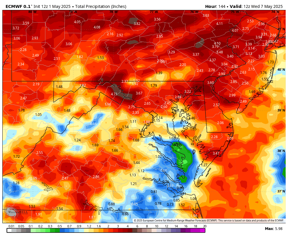
12z Euro: 12z GFS:
-
The euro is doing a pretty good job at depicting the desert of Stephens City.
-
Finally cashed with a nice rain, 1.06" overnight
-
Definitely this Saturday went from sunny in mid 60s to mid 50s probably cloudy and possible rain. No bueno for outdoor music
- Today
-
81/66
-
No rush on any drought denting thread... still looking a 20% coverage 5" but ensembles and WPC below that and definitely I95 inland, at least through Monday. End of whatever happens is probably with the leftover upper low passage Wednesday evening. Most of the rain as per WPC 17z D1-D6. Overall, due to the previous 9 months (or so) drier than normal pattern, most of the area should handle the coming (welcomed) rains. Will rereview at 830A Friday for a possible thread and then probably out of the loop through at least early Sunday afternoon. If a thread posts, it will include OBS. Just waiting it out. For now, not quite there in my mind for a thread. Have a good rest of the day - evening.
-
12z Euro (HINT: Most of that falls through next week): 12z GFS:
-
Below are the May area climate records since 1893 for Chester and SE Berks Counties. During May our average high temperature increased by almost 10 degrees from the upper 60's today to the upper 70's by the end of the month.

-

E PA/NJ/DE Spring 2025 Obs/Discussion
ChescoWx replied to PhiEaglesfan712's topic in Philadelphia Region
Below are the May area climate records since 1893 for Chester and SE Berks Counties. During May our average high temperature increased by almost 10 degrees from the upper 60's today to the upper 70's by the end of the month.
-

2025 Spring/Summer Mountain Thread
Met1985 replied to Maggie Valley Steve's topic in Southeastern States
Big storms rolling through Morganton currently. -
WB 12 Z EURO precip totals through Day 6