All Activity
- Past hour
-
Yeah, it's a real comforting feeling....
-

December 2025 regional war/obs/disco thread
40/70 Benchmark replied to Torch Tiger's topic in New England
Southeast ridge and it's army of MC MJO phases...."I'll be back". -
Windex in the stocking but not the snow kind
-
The wave at 144 on the 6z euro is more amplified. Lets see if we can finally get on board.
-
Yeah lol
-

The Monday wintry event potential (12/8/25)
NorthHillsWx replied to GaWx's topic in Southeastern States
37, 37 here. Don’t think there’s been a northern trend or really much movement at all in models, just need the precip. The heavier totals in VA are from more precip, not more northern movement of the system. Precip amounts have increased south of there into NC as well. Models have generally been ticking up over the last 3 days especially in Virginia where a legit storm looks likely. Here in NC it’s all about how much precip gets in after the front. Current advisory outline looks correct. I expect 1/2” to 1” for the advisory area increasing to 2-3” for the border. Travel issue should be limited until this evening but overnight/tomorrow morning roads are going to be terrible area wide with the flash freeze coming this evening regardless of whether snow accumulates in your area. -
Enjoy those of you to the south. Seems like a decade of getting fringed to the south at this point. ANd this time I am going to miss by like 20 miles. It is getting old.
-
.thumb.jpg.ad3a2e31d30aff035044689b311a0540.jpg)
Winter 2025-26 Short Range Discussion
nvck replied to SchaumburgStormer's topic in Lakes/Ohio Valley
6z HRRR way, way north with the Wednesday system, and about 10mb deeper, faster than any other model -

2025-2026 Fall/Winter Mountain Thread
Maggie Valley Steve replied to Buckethead's topic in Southeastern States
Just woke up and walked the dogs. 34 with a rain/snow mix. Cataloochee is snowing and 31. -
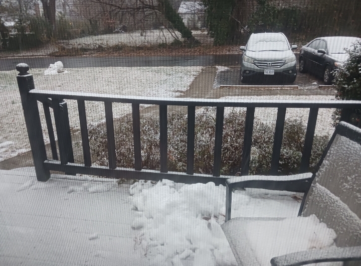
Light snow with pretty small flakes. Sticking to all grassy services now, sidewalk just in the beginning stages of caving
-
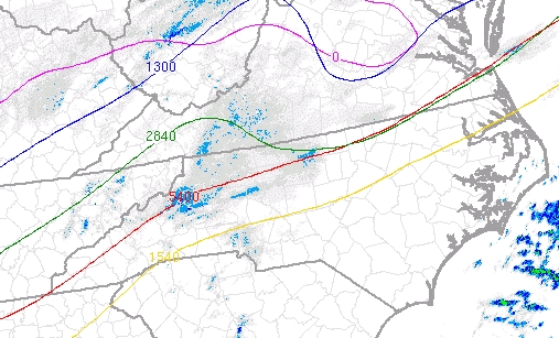
Can see some colder air move in as thickness drops into mountains and Piedmont. SPC Hourly Mesoscale Analysis
-

The Monday wintry event potential (12/8/25)
landof2rivers replied to GaWx's topic in Southeastern States
I was optimistic last night coming home from Pfafftown as the temp dropped and was 32* when I got home. I checked a few times overnight and the temp went to 34*, then 35* and now it’s 36*. We have light rain and I’m hoping the cold air north of Dville makes its way here. -
No one has mentioned it but the long range is looking torchy again.
-

The Monday wintry event potential (12/8/25)
Buddy1987 replied to GaWx's topic in Southeastern States
Well that escalated quickly lol.. within the last 10 minutes elevated surfaces have caved rapidly. Gonna be beautiful outside in a little bit. -
December 2025 regional war/obs/disco thread
40/70 Benchmark replied to Torch Tiger's topic in New England
If it's not going to snow either way, I'd prefer it warm up latter December, in order to avoid parting ways with my seasonal. -
December 2025 regional war/obs/disco thread
40/70 Benchmark replied to Torch Tiger's topic in New England
Is that the AI? -

Winter 2025-26 Short Range Discussion
A-L-E-K replied to SchaumburgStormer's topic in Lakes/Ohio Valley
the chicago rainer detroit snow probably a p rare bird -
Sprinkles around 7:40 at my house near Carytown (RVA)
-
Ditto. I bottomed out at 25.9 about 2 am, then rose to just above freezing at 5 am. Luckily started as all snow here, had 0.5" OTG at 7 am CoCoRaHS report, but it has really cranked up since with big quarter to half dollar sized flakes and I'd say we've passed the inch mark. Temp down to 31.5/30.0 at 7:30 am. Sticking to everything like the last snow, beautiful!
-
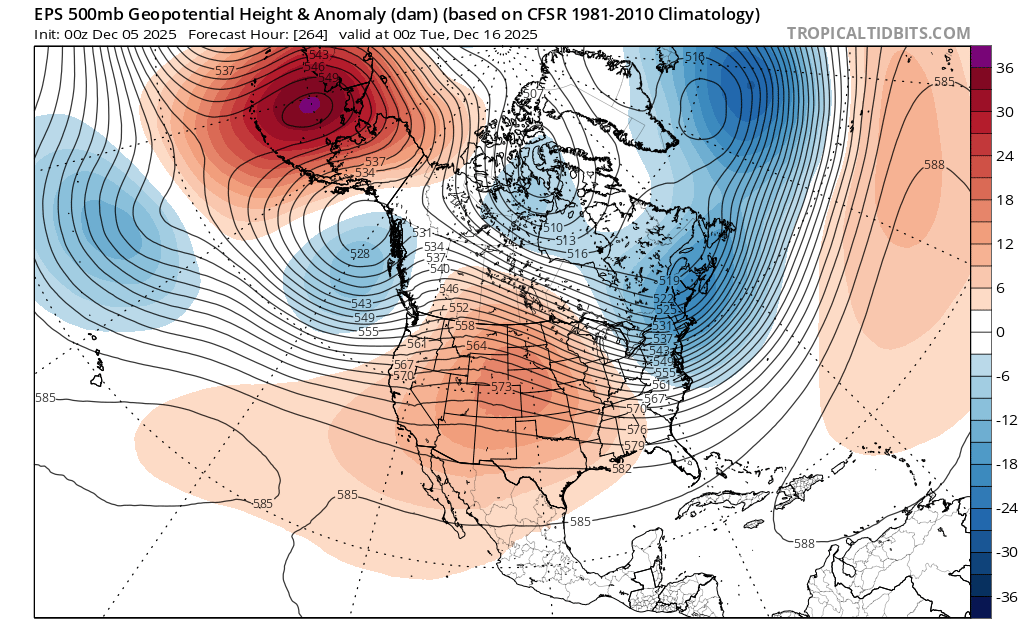
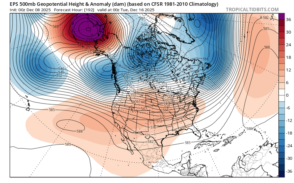
This has been due to the inability of the models to resolve the split forcing pattern which has been in place this month so far. So the first 16 days of the month will verify significantly colder than the long range forecasts were indicating back in late November. La Nina’s often had colder patterns in December so this isn’t that much of a surprise. The interference pattern has created a cold MJO 6 type and not the canonical MJO 8 pattern and storm track. This is due to the forcing near the MJO 4-6 regions with the standing wave. So now that the models have a consolidation of forcing there as the forcing weakens over the Western Hemisphere, they are showing the seasonal moderation in temperatures we often see beginning in mid-December. The last few days have been the first time in a while that they are actually raising heights more than in earlier runs. So the ridge coming east faster is a function of the big Jet extension and MJO 4-6 forcing. Remember last early December how the models underestimated the mid to late December Jet extension and lower Pacific heights. New run faster Pacific Jet lowering heights more over Western North America and raising heights in the East Old run weaker Pacific Jet and stronger ridge out West

-

Winter 25/26 General Obs
Holston_River_Rambler replied to Holston_River_Rambler's topic in Tennessee Valley
Pretty obvious melting layer on radar this AM: -

Richmond Metro/Hampton Roads Area Discussion
Conway7305 replied to RIC Airport's topic in Mid Atlantic
Anyone in Richmond or West seeing flakes. Nothing yet in Henrico -
Moderate rain over to moderate snow. Temp went from 36 down to 33. Elevated surfaces caving rapidly now.
-
Nothing Yet in RVA
-
.thumb.png.4150b06c63a21f61052e47a612bf1818.png)
December 2025 regional war/obs/disco thread
HIPPYVALLEY replied to Torch Tiger's topic in New England
Yep, at least you get frozen ponds.