All Activity
- Past hour
-
This is not your typical heat wave coming up. Ensembles and model runs are getting more intense every day. This is some historic stuff coming up. 600dm showing up on GFS
-
Hottest euro run yet
-
.65" in the last 12 hours, 2.46" for the month.
-
Another. 07 overnight event total 2.84. I'm not sure if anymore is on the way before we bake but I'd bet all of the wet from me on south mutes some of the heat coming up. Instead of 97 it will probably be 95
-
Picked a good week for vacation https://bsky.app/profile/wxmvpete.bsky.social/post/3lrs7sohee222
-
.65" in the last 12 hours now.
-
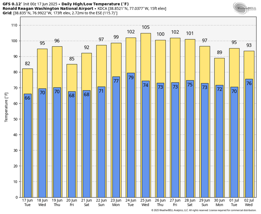
WB 0Z GFS is hot next week as well...
-
What does GFS show. Thought Euro ran several degrees too high, but still we roast.
-
We’ve had continuous light drizzle all night. Wondering how much we are up to since this event began last Friday. Every drop counts with this projected torch; also I’d prefer to avoid hand watering my newest gardens that I installed in May
-
Ensembles are getting stronger with the heat dome. 600dm now showing up on GFS.
- Today
-
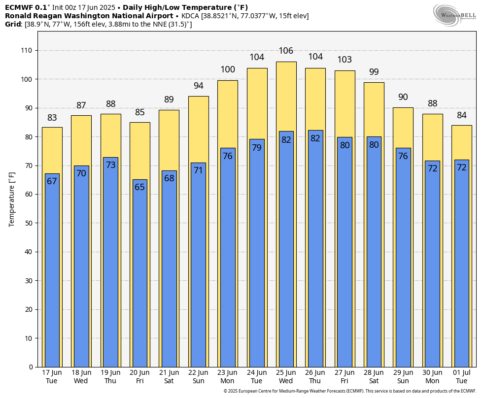
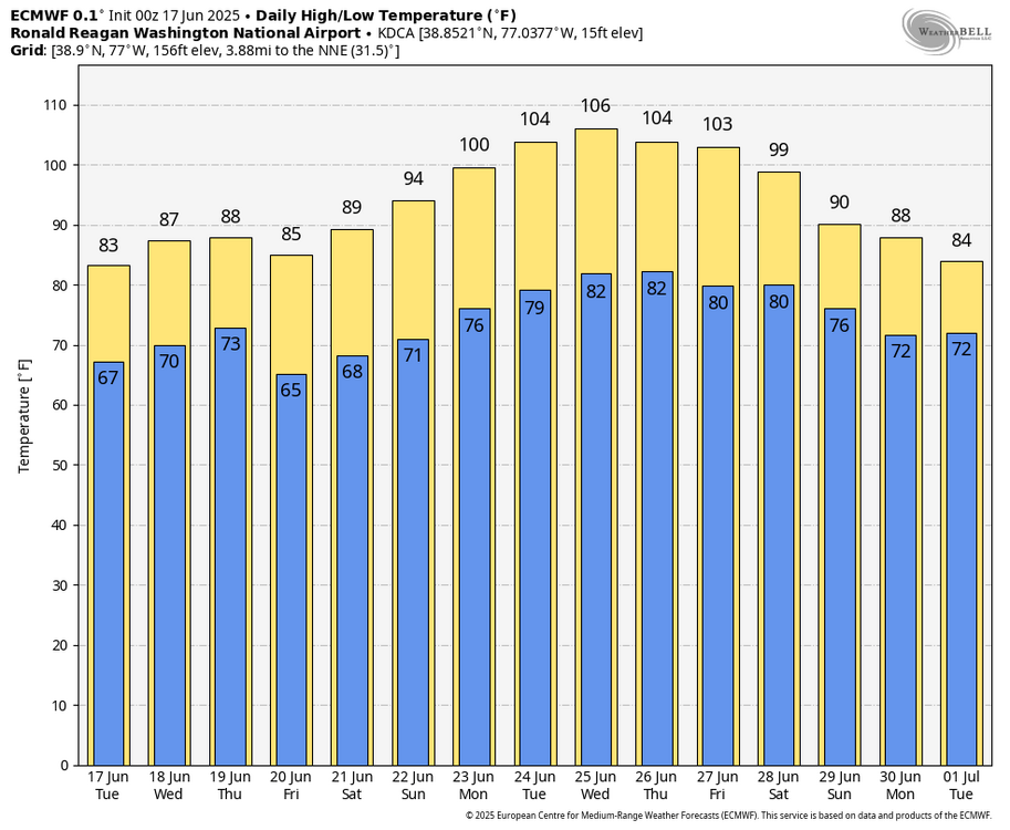
WB 0Z EURO. Get the ac checked. High heat on the way next week.... with low 100s forecasted several days. Peak may be Wednesday: 106 at DCA!
-
-

2025-2026 ENSO
Stormchaserchuck1 replied to 40/70 Benchmark's topic in Weather Forecasting and Discussion
Continued really strong +NAO/+AO pattern.. the CPC readings don't go that high, but the 500mb over Greenland and the Davis Strait rival a 3-standard deviation trough. We saw the same exact thing last year, weeks after major solar flares (which we had a short time ago) Say what you want about Winter -NAO not correlating with East coast troughs, but we have seen some really extreme ridges under strong +NAO H5 patterns since January 2024. -
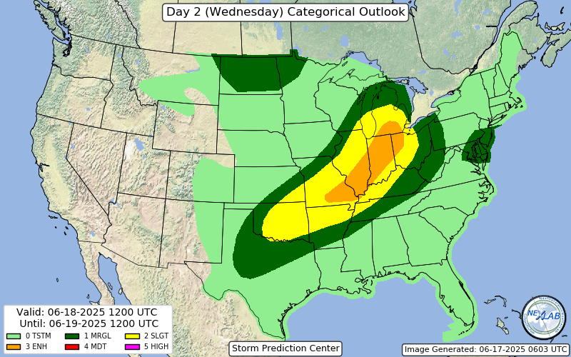
Wind driven enhanced introduced, could see a 10% TOR getting added if the nastier solutions look more likely
-
Picked up another .50" yesterday. This brings my monthly total to 4.06".
-
we have had thunderstorms and i heard thunder a few times here in nyc
-
2025-2026 ENSO
Stormchaserchuck1 replied to 40/70 Benchmark's topic in Weather Forecasting and Discussion
Breaking 6000dm on the 0z GFS.. I was wrong about no extreme heat. This is one heck of a way to even out this unusual mid-June cool period. -
00Z GFS did NOT have the backdoor cold front Wednesday. It stayed well to our north then got here Friday night and quickly washed out with 576dm thicknesses building around it. The 00Z GFS when compared to the 12Z GFS is hotter and longer duration heat lasting from Sunday through perhaps Saturday or even maybe the following Sunday. And wouldn't you know, the heat is poised to rebuild into the region the very beginning of July according to its fantasy range maps. There'll be lots of thunderstorm activity IMO. The GGEM did have the Wednesday evening cold front with cooler weather Thursday & Friday (onshore winds). WX/PT
-
*Sigh*. Guess I'll armchair chase an event off to the east after two days of armchair chasing events off to the west.
-
 weatherva joined the community
 -
Hopefully we'll see some big-time t-storms this summer. I enjoy a good t-storm almost as much as a snowstorm.
-
Your girlfriend likes rain that much?.
-
We need a classic night-time lightning barrage. Did yall see that tornado in Somerset Nebraska today! Holy photogenic batman!
-
I had to pay a cop $75 to avoid a Mexican jail cell there my senior year of HS. Corrupt prick, he was.
-
I’m not sure what your budget is but here are some more choices in VT. I’ve played these and they are nice Quechee has two courses, the Lakeland Course and the Higland Course https://quecheeclub.com https://www.woodstockinn.com/do/things-to-do/woodstock-country-club
-
There is often snow on the ground or it’s too muddy. Mid-May is standard in NNE. My course did the same and you can’t tell. Eastman is a fun course. It’s a more modern design than Lake Morey. Lake Morey is more of a classic old New England design. The resort itself is sort of a throwback too. It has a beautiful location on the lake. In the winter there is a 5 mile long skating track on the lake.