
All Activity
- Past hour
-
4" of snow at BWI between Noon and 1pm with constant thunder and lightning in the February blizzard. And I was out in with my brother pushing my uncle's van down the road so he could get home 5 miles away. Idk how he made it, but he did.
-

Central PA Summer 2026 Discussion/Obs Thread
canderson replied to Voyager's topic in Upstate New York/Pennsylvania
That rain totally missed me somehow -
I was driving back from Bridgewater and had to pull over. Quick, but torrential. My house got .24" in about 4 minutes.
-
That one missed me to the south by a few miles. I see one more downpour a little to my NW -- maybe that one will get me.
-
Light showers im sure they bounced off the ground in Stephens City and back up into the atmosphere
-
They actually did the poles around here last year and even the giant high voltage ones. But yeah you're right, many are old
-

Pittsburgh PA Summer 2026 Thread
Mailman replied to TheClimateChanger's topic in Upstate New York/Pennsylvania
It must rain everyday. -
Had a monster 5 minute downpour
-
Can confirm sharp cutoff - I'm about 2 miles ESE of the Prince Frederick Mesonet and only got about a quarter inch
-
Very light showers moved through. About .03.
-
 Missed a good downpour by a half mile earlier. It was pouring right down the road and by the time I got home it was dry.. looks like we might get a quick downpour now though
 -
Thank you! I do appreciate your interest in this. I have followed the Drought Monitor closely for years and have had faith in its veracity until in recent months. I closely monitor water and soil conditions for some rather large agricultural interests, both topsoil and underground water table. Back in late February when our Augusta water table was 21 ft. below normal, the U.S. Drought Monitor placed Augusta in moderate drought. In late June when our water table had recovered to only 2 ft. below normal after a very wet May, the drought Monitor placed us in severe to Extreme Drought. Go figure On May 19, Augusta was all extreme. Northern Va. was all severe. On June 30, most of northern Va. down to central Rockingham had been downgraded to moderate drought. Augusta was and remains in severe to extreme. I can no longer trust the U.S. Drought Monitor as a reliable source of information.
-
Two consecutive back to back 0.01" readings, rocking here! Course, soon as I type this it starts raining lol.
-

2026-2027 Super El Nino
snowman19 replied to Stormchaserchuck1's topic in Weather Forecasting and Discussion
FWIW here is the new JMA El Niño forecast….same as all the other models this month….showing a historic event -

Central PA Summer 2026 Discussion/Obs Thread
pawatch replied to Voyager's topic in Upstate New York/Pennsylvania
They are forecasting 98 degrees on Tuesday. That’s still pretty warm. I would be happy if we didn’t set anymore heat records. - Today
-
 MANDA changed their profile photo
 -
 Same here, was cloudy earlier but cleared up nicely.
 -
Central PA Summer 2026 Discussion/Obs Thread
canderson replied to Voyager's topic in Upstate New York/Pennsylvania
Thundering and it appears it’s about to pour rain again. The flooding in SE Missouri is catastrophic. 12”+ rain today! -
Who can spot the significant warming of the USA away from our urban heat islands?? This looks a whole lot like Chester County PA - I bet you NCEI chilled the 1920's and 1930's - I always said there is no climate fence around any county!
-
Looks like the southern valley is getting raked by some pretty good storms. We've had about a half inch of rain since midnight here but zero thunder.
-
 60 second sun shower just passed over. Hooray!
 -

Chester County PA - Analytical Battle of Actual vs. Altered Climate Data
chubbs replied to ChescoWx's topic in Climate Change
The science we are talking about is settled and you don't understand it. The average of Phoenixville, Coatesville and West Chester is as warm as the Philadelphia Airport and the Newark Ag station in the early 1940s. The COOP average dropped steadily after 1945 due to cooling moves at Coatesville (1946,48), Phoenixville (1948) and West Chester (1970). By the early 1970s the Coop Avg had dropped to just above Allentown. NCEI was much more stable than the COOP average, staying just above Allentown the entire period. NCEI isn't fooled by station moves. The mistake you are making is assuming that the average of the COOP stations is a good estimate of the county average temperature. That certainly isn't the case before 1970 when the COOP stations are much warmer than the County as a whole.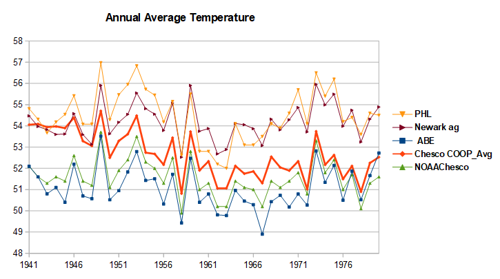
-
Light rain about to reach God’s Forsaken Lands (Stephen’s City)
-
SPC just upgraded day 2 outlook for tomorrow slight risk pushed further in tn now in west and middle tn has 2% in northern and northwest part of west and middle tn 5-15% risk expanded into west and middle tn and a 5% hail risk no cig level hatching https://www.spc.noaa.gov/products/outlook/archive/2026/day2otlk_20260710_1730.html .
-
Here is how those determinations are made: https://droughtmonitor.unl.edu/About/AbouttheData/DroughtClassification.aspx. Summer rainfall does not generally help relieve longer term drought conditions that are dictated by year-on-year water budgets but can help sustain vegetation over the short term.
-

Central PA Summer 2026 Discussion/Obs Thread
Voyager replied to Voyager's topic in Upstate New York/Pennsylvania
Strange goings on here in the Skook. High clouds with the sun shining through, but spitting raindrops from time to time.









(002).thumb.png.6e3d9d46bca5fe41aab7a74871dd8af8.png)





