All Activity
- Past hour
-

Winter 2025-26 Short Range Discussion
Brian D replied to SchaumburgStormer's topic in Lakes/Ohio Valley
I'm ready!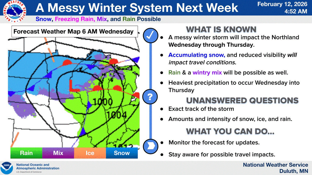
-
 Lol this thread
 -

Is we back? February discussion thread
TauntonBlizzard2013 replied to mahk_webstah's topic in New England
Good luck. My mom says all the time now that if prices were like this 20-25 years ago, you never would have went skiing lol -
Euro goes into 2

-

Is we back? February discussion thread
40/70 Benchmark replied to mahk_webstah's topic in New England
We need to invoke your sig. -
Is we back? February discussion thread
40/70 Benchmark replied to mahk_webstah's topic in New England
That would be more widespread 30"+ than Feb 2013 and 1978.....jesus. It's like 1888 shifted east. -
AIGFS would work too
-
No snow action down this way, almost clear skies. What IS happening is the wind (again). Currently 36.4/17.6 with NW wind 14 gusting to 31 mph. Had a 37 mph gust a bit ago. The snowpack melted down to bare ground on S/SW facing slopes (20%) to 2-3" in shaded areas 80% over the past two days while it was warm, don't think there will be any melting next few days.
-
(002).thumb.png.6e3d9d46bca5fe41aab7a74871dd8af8.png)
Central PA Winter 25/26 Discussion and Obs
ChescoWx replied to MAG5035's topic in Upstate New York/Pennsylvania
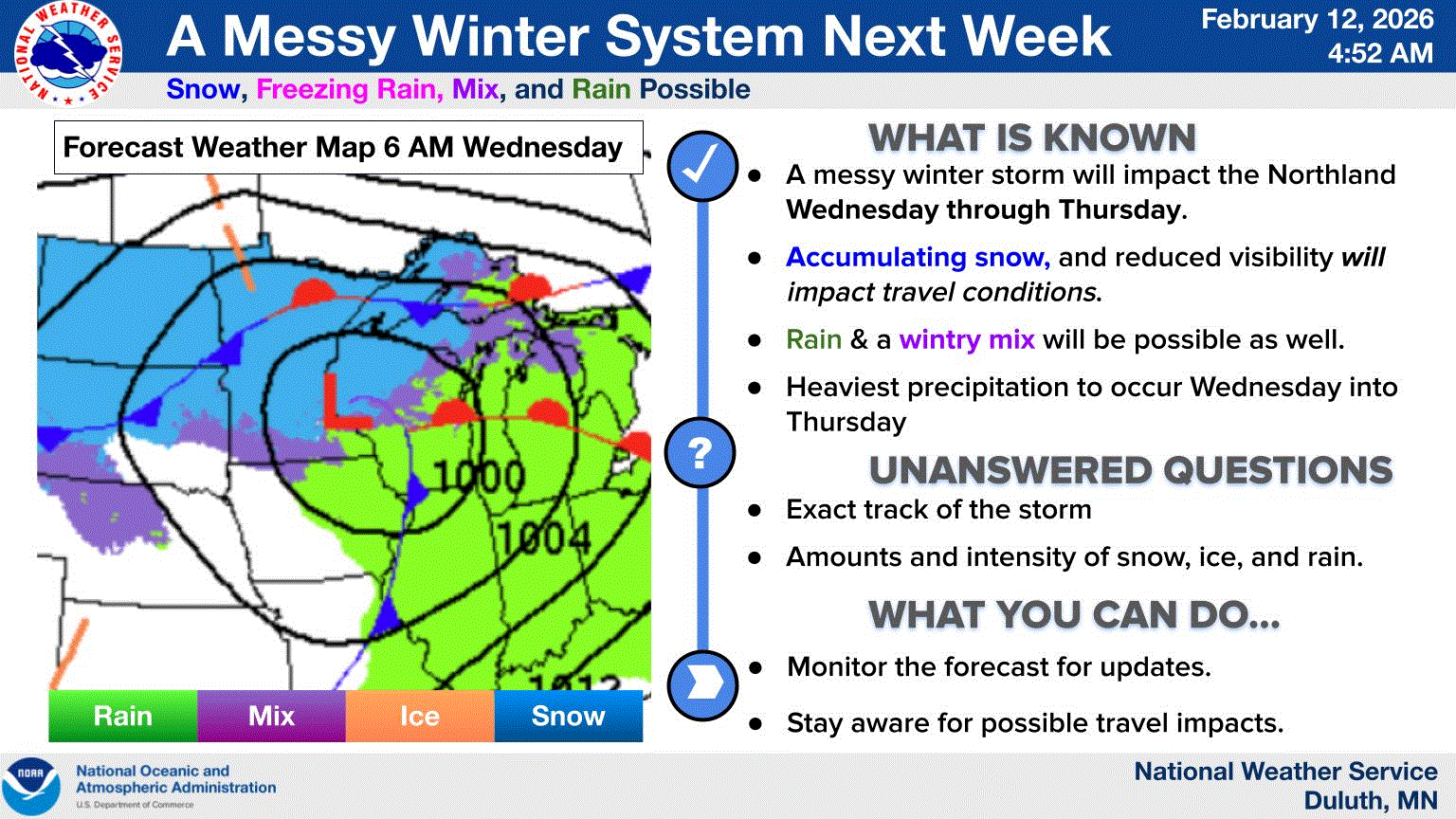
Today is our 27th straight day with snow cover here in Chester County. Tomorrow we will move to the 15th longest such stretch and 24th overall snow cover streak in county history with 133 years of records back to 1893. Below normal temperatures will continue through tomorrow before we warm to near normal temperatures over the weekend. There is a chance of some snow or rain arriving later Sunday with the highest chances across more southern areas. We look to continue to warm next week with temperatures well into the 40's by Tuesday. We will likely turn colder again by the end of new week.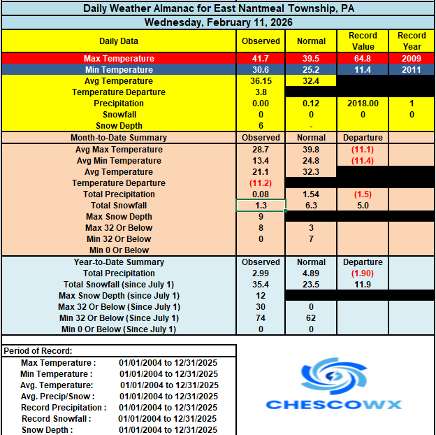

-
E PA/NJ/DE Winter 2025-26 Obs/Discussion
ChescoWx replied to LVblizzard's topic in Philadelphia Region
Today is our 27th straight day with snow cover here in Chester County. Tomorrow we will move to the 15th longest such stretch and 24th overall snow cover streak in county history with 133 years of records back to 1893. Below normal temperatures will continue through tomorrow before we warm to near normal temperatures over the weekend. There is a chance of some snow or rain arriving later Sunday with the highest chances across more southern areas. We look to continue to warm next week with temperatures well into the 40's by Tuesday. We will likely turn colder again by the end of new week.
-

Is we back? February discussion thread
RUNNAWAYICEBERG replied to mahk_webstah's topic in New England
Euro on its way to the adhesive factory while gfs steps up to the podium to announce the mid to long range wintry appeal…? -
 they improved but are still the 4th best in that division. AL East is tough.
 -

Feb 10-11 Mid Week Minor Event - Ride the hot hand?
The 4 Seasons replied to HoarfrostHubb's topic in New England
i see, yea thats probably more like a D than a C -
It looks like I picked a good time to return north…
-

February 2026 Medium/ Long Range Discussion: 150K Salary Needed to Post
CAPE replied to Weather Will's topic in Mid Atlantic
They needed to sign another starter. Was worried Elias was going to pull the same old shit. -

2025-2026 ENSO
TheClimateChanger replied to 40/70 Benchmark's topic in Weather Forecasting and Discussion
For the season as a whole (December & January), NCEI's nClimDiv had us at 6th warmest. Max temps have been running warmer in general for several months, which is a departure from the usual case. For max temps, December & January were 4th warmest for the CONUS. Interestingly, the US Climate Reference Network has this as the warmest December & January (since 2005 & using nClimDiv for 1895-2004), as does the US48 TLT satellite-based anomaly from UAH. By my calculation, February would need to check in around 5.8F above normal to set a new record warm winter for the CONUS or about 3.7F for second warmest. The latter is certainly plausible. I mean the former is possible as well but would require some bigtime positive anomalies (full-blown Feb. 2017/March 2012 torching). I think max temps have the better odds to finish as warmest on record, not sure we get there in the means. It looks like a lock for warmest on record for USCRN (all rural, pristine sited stations with better equipment - e.g., redundant temp. sensors) and in the UAH satellite record. Looks like a new max temp record in the official NCEI records is also a lock. Just need to finish around +3.6F for that one, and we're near +5.2F for the first 10 days (PRISM) with that number likely to climb in coming days. -
At least western resorts can salvage their ski seasons. Looking extremely wet out there rest of this month and those insane snow droughts will be dented
-

Feb 10-11 Mid Week Minor Event - Ride the hot hand?
WxWatcher007 replied to HoarfrostHubb's topic in New England
I went 2-4 northern CT and C-2 south. Far too aggressive but I thought we were moving toward a more amped system. -

February 2026 OBS & Discussion
CPcantmeasuresnow replied to Stormlover74's topic in New York City Metro
Credit to you for admitting your blown forecasts, some on here just run away when they don't work out. Personally, I believe any forecasts one month out or more are just a guessing game. Maybe you can reduce the odds a little with research and analysis but not enough to make them worthwhile in my opinion. -
A live Chia pet!
-
February 12 1988: For warm weather...head west! Duluth had a temperature of 31 below zero, while Rapid City was sitting at 59. 1872: A severe blizzard hits central Minnesota. The temperature at Litchfield was 34 degrees on the afternoon of the 12th, and fell to -20 by the morning of the 13th. At least 6 people died in Meeker County alone. For Thursday, February 12, 2026 1899 - Texas and the eastern plains experienced their coldest morning of modern record. The mercury dipped to 8 degrees below zero at Fort Worth TX, and to 22 degrees below zero at Kansas City MO. The temperature at Camp Clarke NE plunged to 47 degrees below zero to establish a record for the state. In the eastern U.S., Washington D.C. hit 15 degrees below zero, while Charleston SC received a record four inches of snow. (David Ludlum) 1958 - Snow blanketed northern Florida, with Tallahassee reporting a record 2.8 inches. A ship in the Gulf of Mexico, 25 miles south of Fort Morgan AL, reported zero visibility in heavy snow on the afternoon of the 12th. (12th-13th) (The Weather Channel) 1960 - A snowstorm in the Deep South produced more than a foot of snow in Louisiana, Mississippi and Alabama. (David Ludlum) 1987 - A storm in the eastern U.S. produced high winds from North Carolina to Maine. A storm in the western U.S. produced up to thirty inches of snow in the Sierra Nevada Range of California. (The National Weather Summary) (Storm Data) 1988 - A classic "nor'easter" formed off the Carolina coast and intensified as it moved up the Atlantic coast bringing heavy snow to the northeastern U.S. Totals ranged up to 26 inches at Camden NY and Chester MA. Arctic cold gripped the north central U.S. Duluth MN was the cold spot in the nation with a low of 32 degrees below zero. (The National Weather Summary) (Storm Data) 1989 - Unseasonably mild weather prevailed across Alaska. Morning lows of 29 degrees at Anchorage and 31 degrees at Fairbanks were actually warmer than those in northern Florida. (The National Weather Summary) 1990 - Strong southerly winds ahead of an arctic cold front pushed temperatures into the 70s as far north as Iowa and Nebraska. Twenty-one cities in the central U.S., seven in Iowa, reported record high temperatures for the date. Lincoln NE reported a record high of 73 degrees, and the afternoon high of 59 degrees at Minneapolis MN smashed their previous record for the date by twelve degrees. Springfield IL reported a record forty-eight consecutive days with above normal temperatures. (The National Weather Summary) 2006 - An intense snow squall off of Lake Michigan cuts visibility to zero along a section of US 31. The resulting whiteout causes 96 cars to pile up. 25 were injured.
-
Don, do you even think it will take that long? I read an article yesterday at how scary fast AI in general is evolving, apparently it’s leaps and bounds ahead of where it was even just two years ago.
-
2025-2026 ENSO
TheClimateChanger replied to 40/70 Benchmark's topic in Weather Forecasting and Discussion
I'm extremely impressed by this start to February, particularly for high temperatures. Unusually large diurnal ranges are keeping the mean temperatures in check to an extent, but max temps have been soaring. With the current forecast, odds look very good for a top 10 warm February nationally, perhaps top 5. Average high temps are well within striking distance of a number two finish (1954's +7.34F over 1991-2020 mean would be a stretch). -
 At least baseball season is starting, something to look forward to. Love the Bassitt signing.