All Activity
- Past hour
-
Just bigtime LOL that the GFS just 24 hours ago gave us all an areawide 0.0" . Just good stuff from that model.
-
Canadians have a north bias
-
GFS dunks a foot of snow on basically the entire MA and NE (sorry, Maine). One for the ages.
-
The primary goes over Ohio lol
-
GFS shows about 10" of Snow and 2" or so of sleet here... Probably not happening.
-
So, snow w/ the first wave(prior to this slide). Then, it is a classic overrunning event w/ waves just riding the west-east gradient. The last of the energy kicks out and that low in the Panhandle transfers its energy to the low at Hatteras. E TN ends w/ heavy snow. 12-14" of snow for areas about 50 miles north of the Tenn state line - statewide. Has to be crazy amounts of ice south of it. I am only describing the model....I make ZERO claim as to its accuracy and not sure I even agree w/ it. However, that is a plausible scenario if the low doesn't consolidate and the high is strong. I continue to struggle to believe that it is going to rain w/ a 1050 hp leading this off...but I know it can happened. IF that is the likely evolution of the system...just about zero chance this is even remotely nailed down.
-

January 25/26 Jimbo Back Surgery Storm
Blacksburg Coach replied to Jimbo!'s topic in Southeastern States
-

January 2026 regional war/obs/disco thread
TauntonBlizzard2013 replied to Baroclinic Zone's topic in New England
36 hours or so? Sunday through late Monday for many -
Would like to see the qpf start creeping up now. 1.2ish during a 30 hour snowstorm. It’s cool but our greats would have twice that in 30 hrs, maybe even more lol.
-
if the GFS happened as modeled this would go down as an all timer
-
Of course I still stand by my wish that the GFS either didn't exist or was run AFTER the other globals so it didn't get more attention than it deserves (which in my opinion is about NONE). But if we are going to look at it, it might as well be awesome!
-
If anything like the GFS verifies I promise I will be outside Jeb walking the entire event
-

Richmond Metro/Hampton Roads Area Discussion
RVASnowLover replied to RIC Airport's topic in Mid Atlantic
Hard to be mad at this even if we mix. Maybe get the CAD to hang on a little longer. -

January 25-26 Winter Storm Potential
Birds~69 replied to Ralph Wiggum's topic in Philadelphia Region
Lol...I remember 1 other time but there may be more. -
Happily take a concrete bomb at this point (and that’s what I think we’re getting). .
-
The thing is that for as bad as the GFS was a day or two ago being the last to join the party, it isn't a COMPLETELY trash model and can be looked at without distain closer to an event. That said watch it slam a low into Cleveland for the 18z or show suppression to Naples.
-
It hangs back some of the southwestern energy juuuust enough to sort of elongate things though -- dragging snow through basically most of Monday. It's on its own in that regard for the current-most run of the overall suite, but if that starts showing similarly elsewhere then a bit colder, longer solution would seem more likely. Given its performance thus far, I wouldn't necessarily hold my breath on that front; seems to be lagging behind the pack.
-

January 2026 regional war/obs/disco thread
weatherwiz replied to Baroclinic Zone's topic in New England
Verbatim on the GFS I think you would see a major band well up to the Mass Pike. Imagine if we were to pop at 700 low...damn -

January 2026 regional war/obs/disco thread
ineedsnow replied to Baroclinic Zone's topic in New England
this is going to be big! trending towards 12 to 18 plus for many I think. -
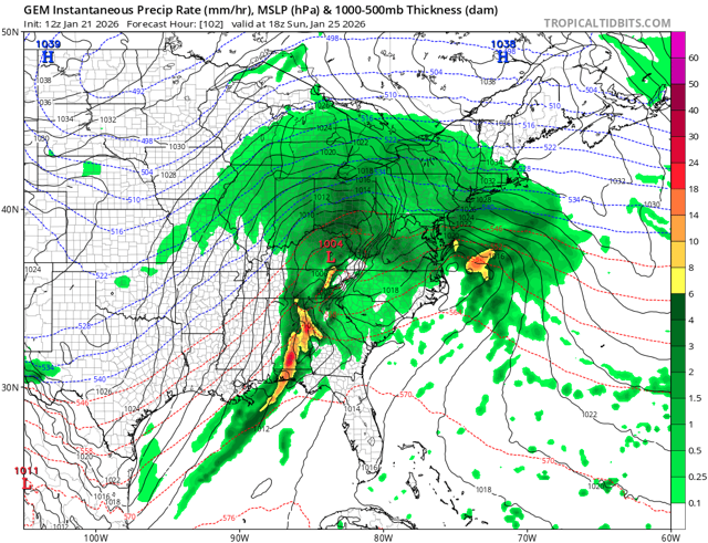
Canadian looks similar to last run. Amped and thermals are a mess.
-

Richmond Metro/Hampton Roads Area Discussion
jlewis1111 replied to RIC Airport's topic in Mid Atlantic
how much is it showing before we change over to sleet here in richmond? Thank you -

“Cory’s in LA! Let’s MECS!” Jan. 24-26 Disco
The 4 Seasons replied to TheSnowman's topic in New England
I know you're referring to the lead post, i was just going back looking at this storm and i remember that insanely long title for the thread and thought it was funny. -
CMC slightly less amped through 93
-
Oh I’d troll him badly via text haha
-

January 25/26 Jimbo Back Surgery Storm
Brick Tamland replied to Jimbo!'s topic in Southeastern States
Well, this is not how I wanted things to go. Sucks you can't depend on the models outside 3 days. Even the king Euro went from a foot of snow to freezing rain in less than a day.


.thumb.jpeg.1d2958065f007d9e7218a8c935ea8246.jpeg)


