All Activity
- Past hour
-
they always predict a very cold PNW if it's a nina. Also it is impressive how little orange they used!
-
Funny, sort of, that I read that just now, right after reading the SWS for here. I was not online yesterday, so: Special Weather Statement National Weather Service Boston/Norton MA 610 PM EDT Fri Sep 19 2025 ...ELEVATED RISK FOR FIRE SPREAD AGAIN SATURDAY... A prolonged period of dry weather and dry fuels will result in elevated fire weather conditions later Saturday morning through Saturday afternoon. Although winds will be rather light from the north at 5-10 mph with a few 20+ mph gusts confined to mainly to the Cape and Islands...the relative humidity will be lower than what we observed today. Minimum relative humidity values will drop to between 25 and 40 percent along and northwest of I-95 and between 40 and 55 percent towards the Cape and Islands. Exercise caution handling any potential ignition sources, including machinery, cigarettes, and matches. Any fires that ignite will have potential to spread quickly. This forecast considers meteorological, fuel, and land conditions and has been developed in coordination with state fire and land management officials. $$ Frank
-
Although the chances are now pretty low, we still don’t know for sure that ACE won’t get to near the 30 yr 122 avg especially based on 2024, 2020, 2016, and 2005, but also on 1894, 1893, and 1878. However, all of these very active Oct+ years were more active through Sept though 2016 and 1894 not by that much.
-
Yep, I can almost smell the late phase coming that cashes in everyone east of I-77.
-
BTV upgraded to a freeze warning for tonight with upper 20s. Seeing as we got to 32F last night, does tonight end the growing season? I'd think if we get to 28F or so that'll lead to a much harder and widespread frost/freeze.
-
Looks like a lot of chances for rain next week. Stupid people wishing for it...
-

September 2025 General Discussion
TheClimateChanger replied to Geoboy645's topic in Lakes/Ohio Valley
Yes, looks like our spell of nearly ideal weather is coming to an end. -
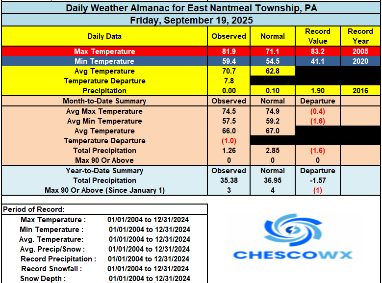
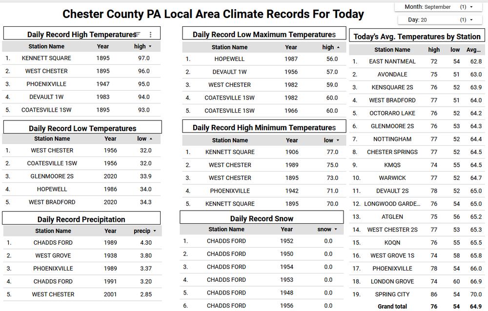
A beautiful weekend underway across the area. Some of our cooler valley locations like Warwick Township reached the 40's for low temperatures this morning. We should run at least 5 to 8 degrees cooler than yesterday for most spots. Some ridge locations may now get much above the lower 70's while valley spots could see the mid to upper 70's. We turn a few degrees cooler tomorrow before a slow warm up to well into the 70's by Tuesday before another cooldown to close out the work week. We do have some rain chances increasing by Tuesday and looks like it will last through the rest of the week. Let’s hope we cash in on some of that liquid gold!
-
(002).thumb.png.6e3d9d46bca5fe41aab7a74871dd8af8.png)
E PA/NJ/DE Autumn 2025 Obs/Discussion
ChescoWx replied to PhiEaglesfan712's topic in Philadelphia Region
A beautiful weekend underway across the area. Some of our cooler valley locations like Warwick Township reached the 40's for low temperatures this morning. We should run at least 5 to 8 degrees cooler than yesterday for most spots. Some ridge locations may now get much above the lower 70's while valley spots could see the mid to upper 70's. We turn a few degrees cooler tomorrow before a slow warm up to well into the 70's by Tuesday before another cooldown to close out the work week. We do have some rain chances increasing by Tuesday and looks like it will last through the rest of the week. Let’s hope we cash in on some of that liquid gold!
-
Football game was OK last night. Rain ended, and field was in good condition. It wasn't the homecoming game like I thought, that's in 2 weeks. My bad. But TH won against Pine City 7-0. Awesome defensive battle. THHS is 3-1 for the season so far. Still a wet day with drizzle, and shwrs around. Nearly an inch of rain so far the last couple days.
-

Occasional Thoughts on Climate Change
donsutherland1 replied to donsutherland1's topic in Climate Change
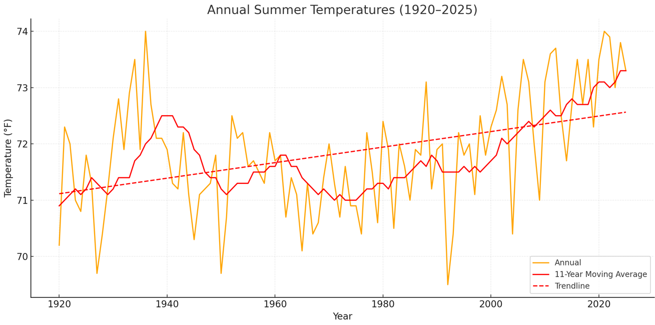
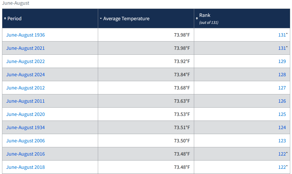
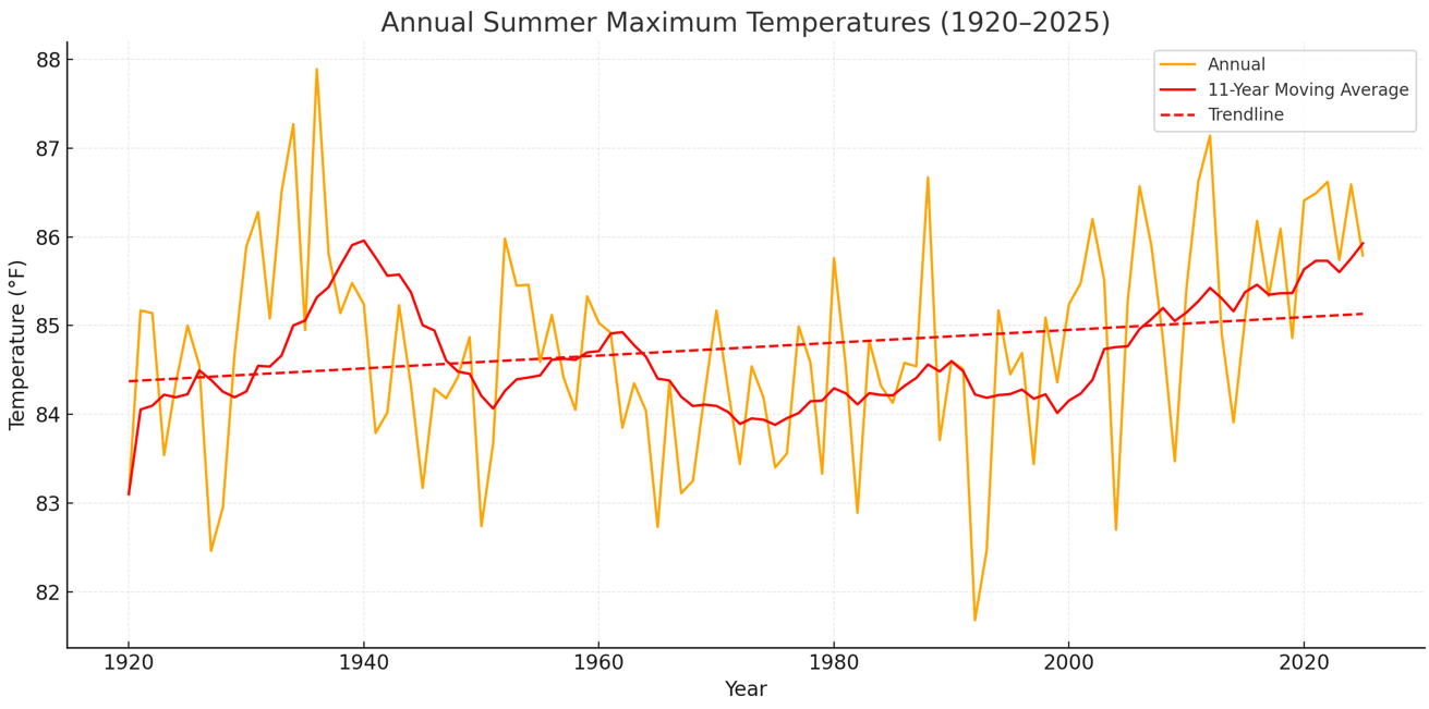
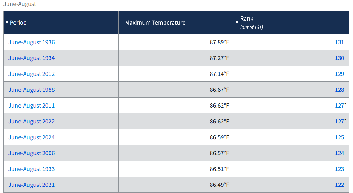
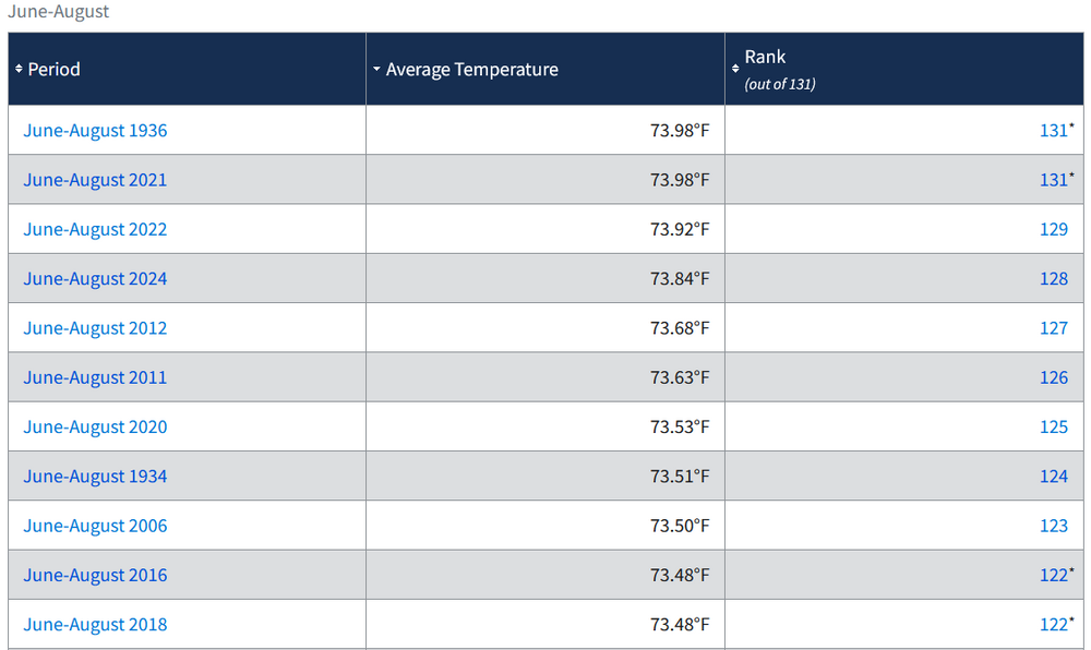
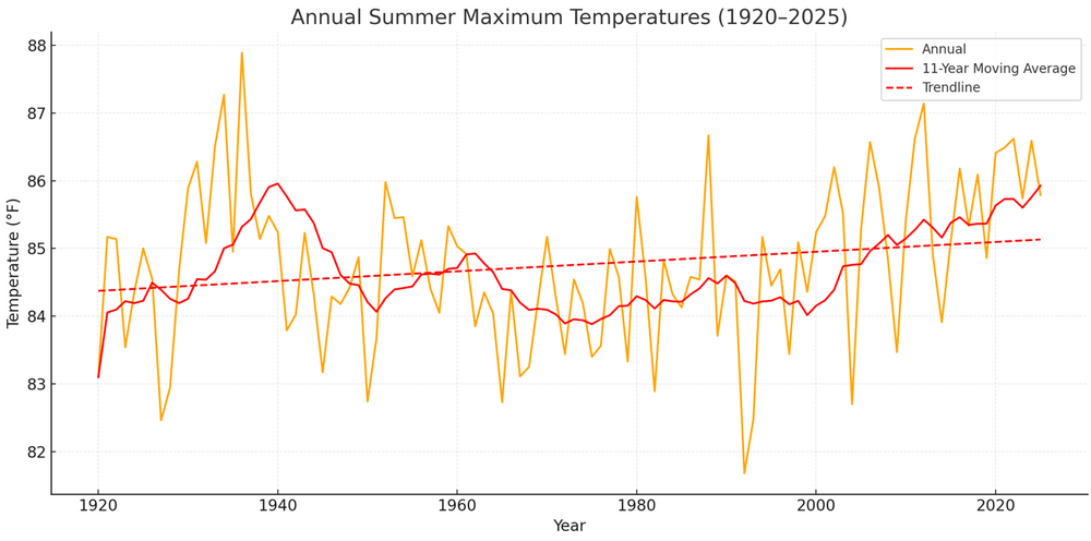
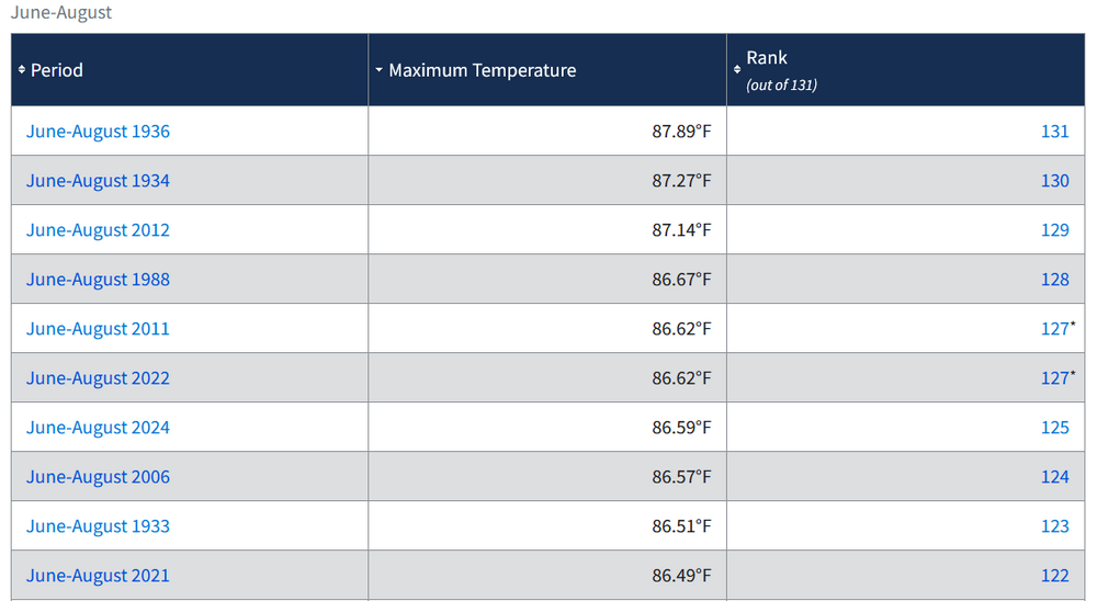
Below is an illustration of how Social Media's climate change denial scammers mislead when it comes to U.S. temperatures. Notice several things: 1) The 11-year moving average stops short of the chart's end to make things look even cooler than they are 2) The chart is based on maximum temperatures, only. Climate is based on the entire set of temperatures, not just maximum temperatures. Hence, it is good and customary practice to assess climate change based on mean, not maximum temperatures. 3) The chart relies on raw data, only. Doing so is unreliable due to a range of issues, including but not limited to, new stations, eliminated stations, station moves, time of observation, etc. Now to the actual facts: 1) Summers are generally warmer than they were during the Dust Bowl Era on an 11-year moving average (the average used above) and they are warming (trend line): 2) In terms of maximum temperatures, summers are nearing the drought-inflated maximum values achieved during the Dust Bowl Era on an 11-year basis: Note: All data in my charts is official NOAA data.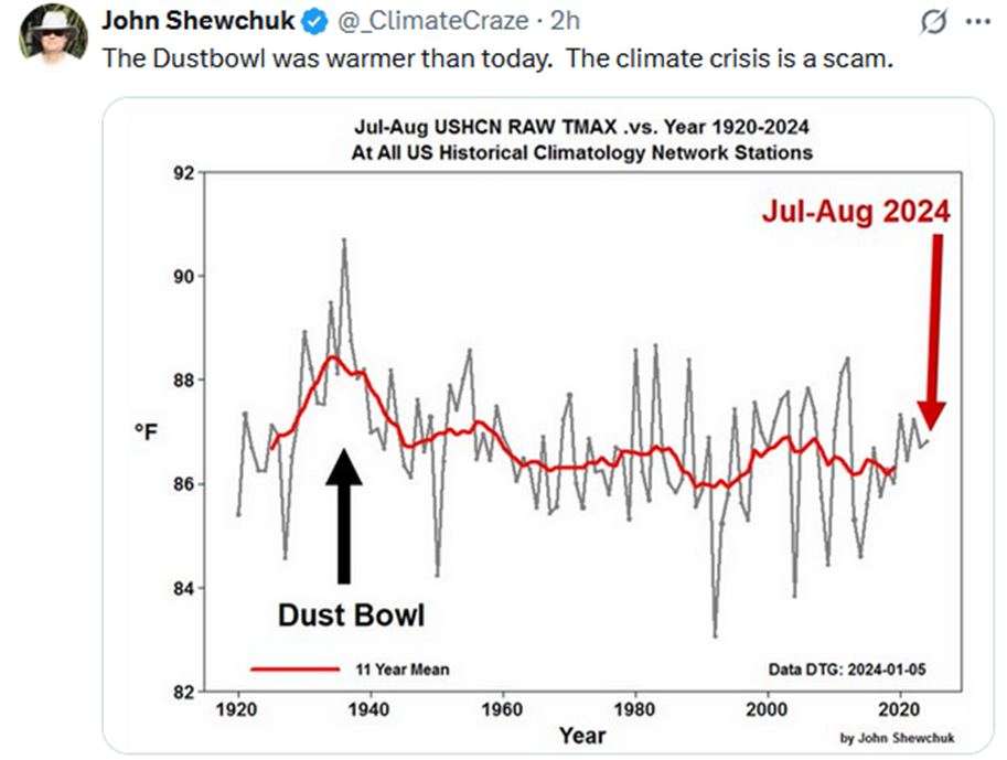

-
We had some rain up here at the cabin yesterday night and it really cooled down. I fired up the wood stove quick to give it a test run before winter. Gonna go hiking in savage river SF this morning, sunny and breezy at 66F right now.
- Today
-
Good. The lack of casualties, misery, and destruction so far is a great thing! We’ve had enough of this crap. But unfortunately Oct has produced really bad storms, especially in recent years. So, the jury is still far from coming back with a full verdict for the season. Although the chances are now pretty low, we still don’t know for sure that ACE won’t get to near the 30 yr 122 avg especially based on 2024, 2020, 2016, and 2005, but also on 1894, 1893, and 1878. However, all of these very active Oct+ years were more active through Sept though 2016 and 1894 not that much.
-
Got down to 38 here.. I think we frost tonight..
-
Woke up to a heavy shower around 3am or so and found a gloriously unexpected 0.15" in my gauge this morning.
-
43.7 this morning. Lowest since June 2.
-
BDL maxima in the 4th week of September are low 70s. So now +5 is a "furnace"? First (light) frost this morning, low of 30. Our 28-year average for first frost is . . . today. (Though recent years have averaged later.) Will salvage cherry tomatoes and peppers today, as we'll likely dip into the 20s tonight. Covered the peppers last night as they're only 1-2 feet tall. All the remaining 'maters are 4-5 feet off the ground so safe from light frosts.
-
 Ragasa is looking mean this morning. I’m shocked Josh is chasing this, looks like it is traveling between the uprights in terms of splitting the populated islands in the area
 -
Beautiful morning here. Drier than I expected with this east wind. I blow the moisture off my cannabis plants with my leaf blower and their was hardly any dew this morning. It's going to be a beautiful day with these scattered clouds and breeze.
-
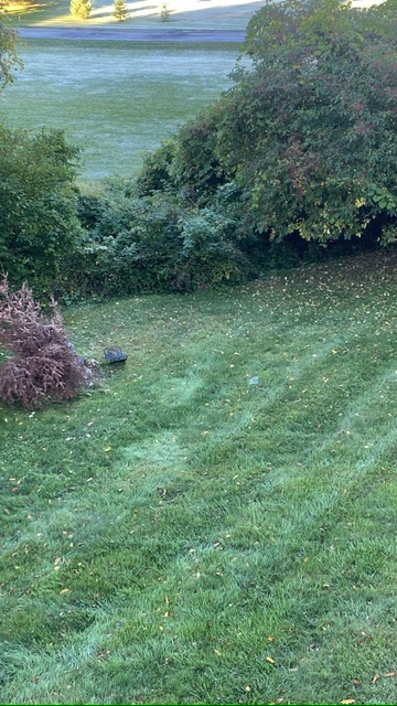
Patchy frost around here. On cars and any open areas, low spots. Frost out on the open lawn in this shot but not near the bushes.
-

2025 Atlantic Hurricane Season
WxWatcher007 replied to BarryStantonGBP's topic in Tropical Headquarters
I’ll take the over on no development after Gabby lol. You could see the tropical Atlantic being a dead zone again from a mile away—the real question is what happens when climo shifts to the Caribbean and homebrew regions. Those areas have been warmer with more instability and less shear all season. If their peak season is a bust, then we’ll be in bust territory. -

Central PA Summer 2025
Mount Joy Snowman replied to Voyager's topic in Upstate New York/Pennsylvania
Low of 59. Should be a glorious weekend. -

September 2025 OBS-Discussion centered NYC subforum
SACRUS replied to wdrag's topic in New York City Metro
65 / 44 clear . Sunny today cooler low - upper 70s in the warmest areas. A bit cooler tomorrow. Overall warmer and perhaps a period of rain as another low cuts off under the ridge between Tue - Sat next week. Will see where it does and which areas get some rains. -
Another season where many forecasters had the east coast above average chance with alot of storms. Just like winter outlooks, take the tropical outlooks with a grain of salt or maybe not do outlooks way far in advance.
-
Will my next measurable precip be snow?