All Activity
- Past hour
-

February 2026 Medium/ Long Range Discussion: Buckle Up!
psuhoffman replied to Weather Will's topic in Mid Atlantic
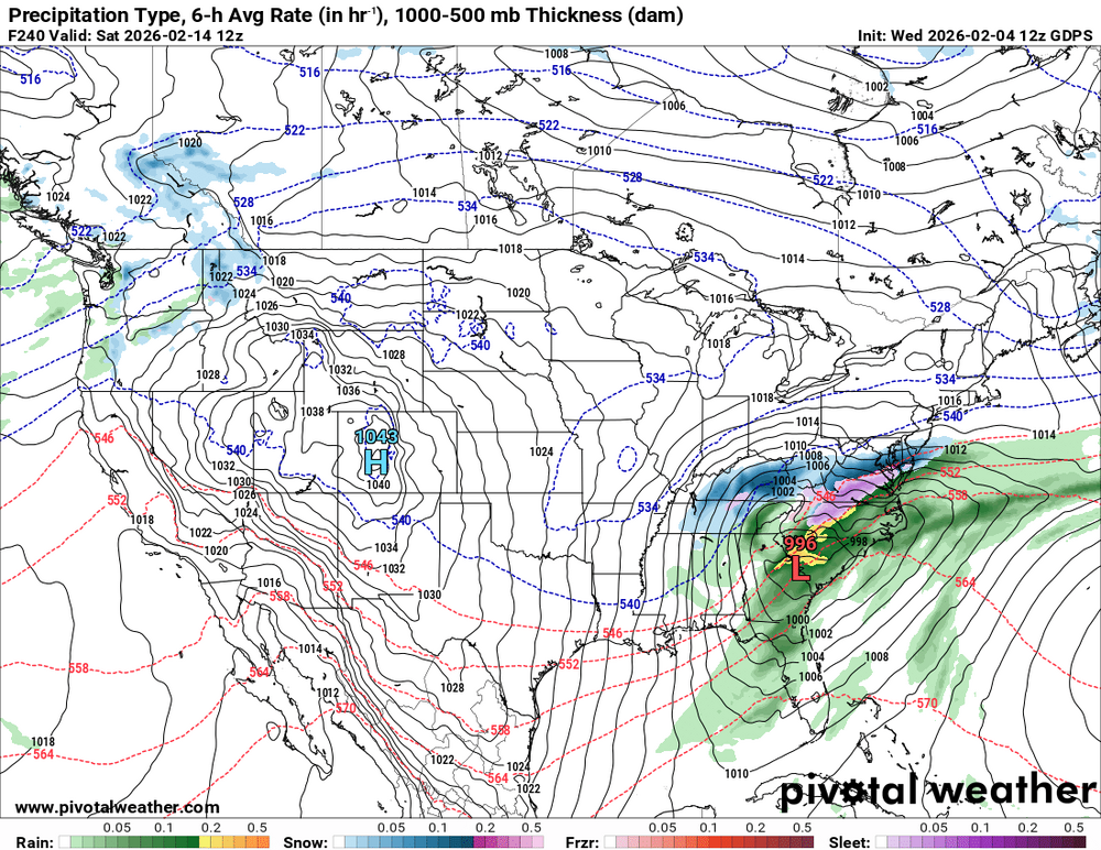
after all the complaining of a torch and end of snow threats it's going to be funny if we end up worrying about suppression and a NC snowstorm again. -
Maybe not..... This is our year. How many time have we seen long range torches get muted or replaced by cold? Happening a lot this winter as we get closer to verification time. It just wants to be cold in the east.
-
Yeah that’s later on post-Ides. I have no idea what’s going to happen during that late Feb/early Mar period. If you keep the Atlantic blocking during that period and then try and insert a -EPO, then we could get something exotic.
-

February 2026 Medium/ Long Range Discussion: Buckle Up!
WxUSAF replied to Weather Will's topic in Mid Atlantic
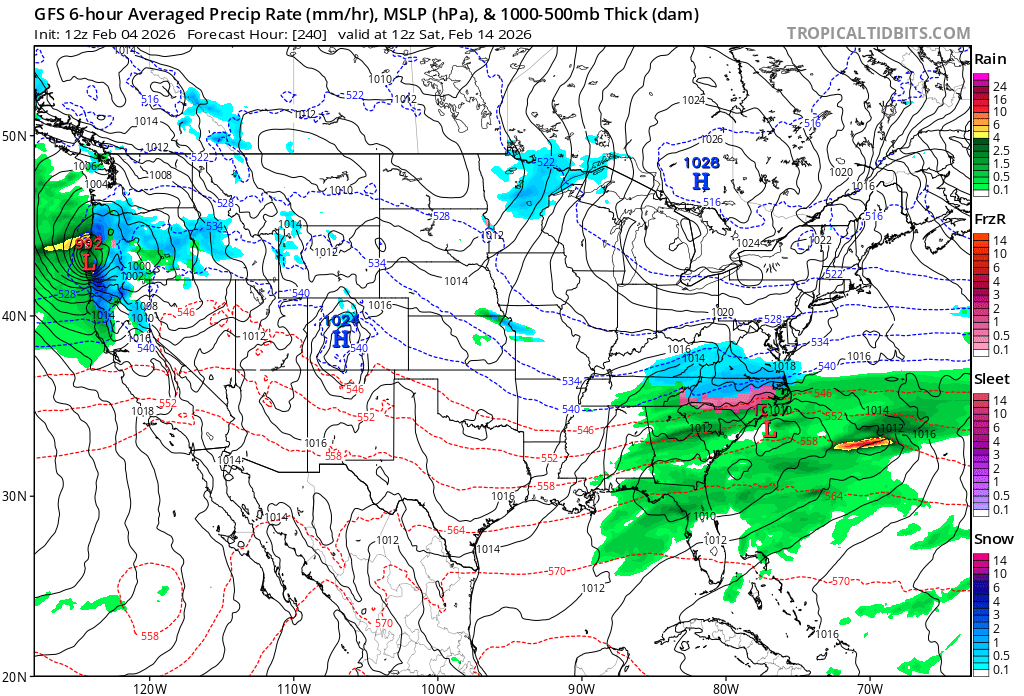
Maybe I just started paying any attention (likely, was focused on WWAW), but the front runner Tuesday-Wednesday sets the boundary to our south and then we want a decently strong wave to ride along it next Friday-Saturday. That’s a pretty classic order of operations for us. -
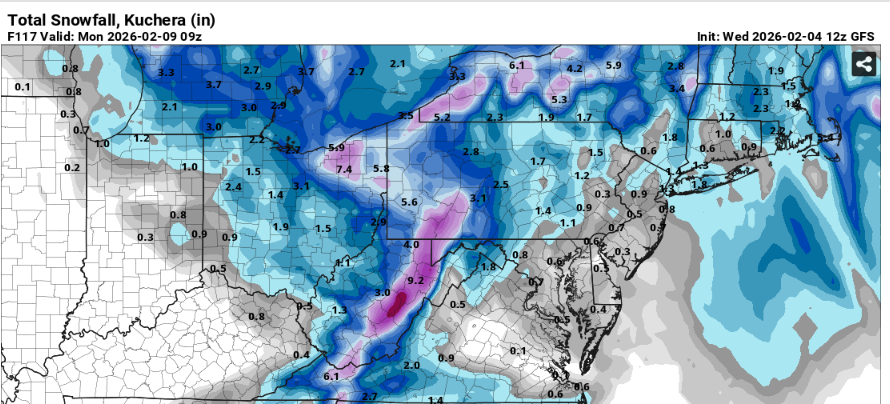
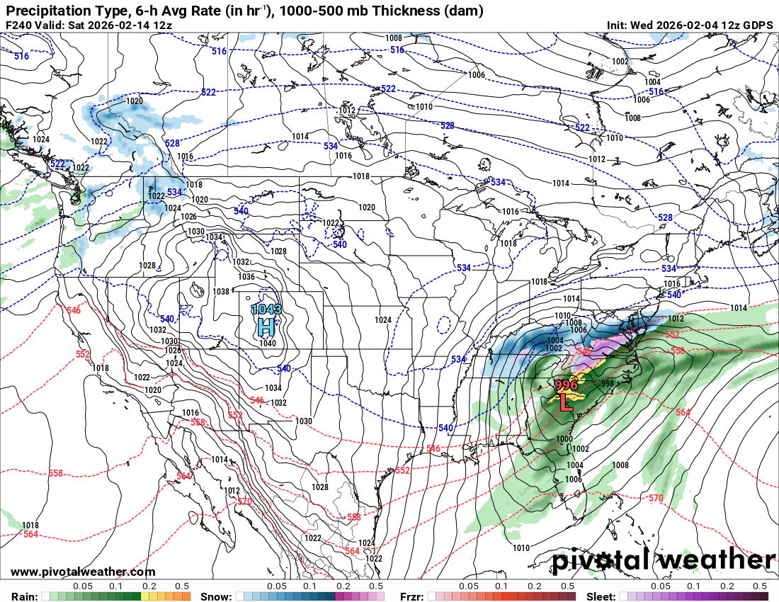
Gfs AI from best I can tell on pivotal based on qpf and temps has a moderate snowstorm and close to something bigger. .
-
Based on what was going around on social media I don't know where the idea came really of a "torch" or whatever you want to call it upcoming. I mean we were clearly going to moderate from what we've been experiencing. This is when anomaly maps get tossed around and are used and interpreted incorrectly. We are still in peak climo in terms of temperatures...orange and red shadings on anomaly maps don't necessarily indicate or mean warm...we can still be above average and its still relatively cold or chilly or whatever. The only areas where its clear there will be a significant warmup is within the central Plains. Even those temp anomaly maps from BAM or sham or whoever...+12 to +15 in the upper-Midwest this time of year is still chilly
-

February 2026 Medium/ Long Range Discussion: Buckle Up!
Terpeast replied to Weather Will's topic in Mid Atlantic
If I wanted to troll the forum, I would post this: Oh wait... (its an op run 10 days away, so don't take it too seriously)
-
Interesting look on the Canadian
-

Central PA Winter 25/26 Discussion and Obs
canderson replied to MAG5035's topic in Upstate New York/Pennsylvania
Yea, I have 3-4 shovels now for different types of snow but not really a great tool for chipping off and moving ice. A coal shovel is an interesting thought and might be perfect. -

February 2026 Medium/ Long Range Discussion: Buckle Up!
mitchnick replied to Weather Will's topic in Mid Atlantic
Don't forget the Kennedy inauguration storm. -
Happy birthday to me, I hope.
-
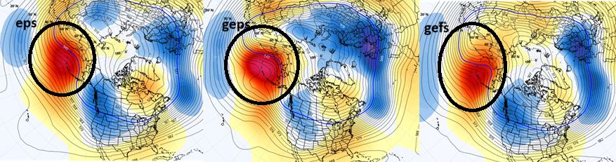
It's not the Atlantic that you gotta worry about as a spring/early warm enthusiast... Oh it's not helping, sure. But the biggest player is what everyone is either ignoring, or just haven't seen yet because it's bursting onto the ens means ( all three - ) over just the last 6 or so cycles... That's more than eerily similar to the -WPO/-EPO hybrid pattern that locked out late Nov to after Xmas and utterly dictated matters... it's identical. This is also coupled to the ridge showing up in the 100 hPa level in the Strat/Trop monitoring, which also did the same thing back whence and a lot of folks were fooled into believing it was an early season SSW... just like there are those thinking similarly now. But it's not clear to me because it is not, frankly, a true up--> down intrusion/propagating event. This is just a hemispheric shuffle... or re-shuffle... The ideas of a warm post mid month ( as I warned yesterday...) might be in trouble as these patterns repeat over longer periods.
-

Winter 2025-26 Medium/Long Range Discussion
Malacka11 replied to michsnowfreak's topic in Lakes/Ohio Valley
Yeah basically looks like the rest of the season can be written off at this point. First torch is already locked in and after that I'd rather just save the ol' climo luck points for next season -
It's not technically an under-measurement if the observer is following the standard that they are supposed too. The problem is that there are different standards for different types of observers. I'll never beat ISP in a big storm unless they rain and I don't because they are supposed to wipe the board every 6 hours and I am not. In the most recent storm, ISP reported 13.2" and I had 11.4". I don't think they had more snow than I did (plus we snowed heavily a little longer before changeover to sleet), but both measurements can be technically correct. I suspect the once in 24 hours max depth standard might be designed to make it easier for observers, plus in some instances (not all) it is a more accurate way to portray the snowfall. Wiping the board more often makes sense for airports because it relates more directly to wiping the snow from runways. It is frustrating that we can't do apples to apples comparisons, especially when doing projects like The 4 Seasons is doing. For my money, snow depth and LE of the snowpack are the best way to compare between sites.
-
Hope not. All set wasting weeks of peak climo.
-

February 2026 Medium/ Long Range Discussion: Buckle Up!
Heisy replied to Weather Will's topic in Mid Atlantic
12z cmc was a MECS in the making. Still at long range, just good to see -
Turn in you membership card !
-

Is we back? February discussion thread
40/70 Benchmark replied to mahk_webstah's topic in New England
GEFS probably won't. -

Central PA Winter 25/26 Discussion and Obs
Voyager replied to MAG5035's topic in Upstate New York/Pennsylvania
A regular flat garden shovel works well, but it sounds like you want a bigger scoop. Those, however, are usually aluminum. You want steel if you're going to get into chopping and digging ice. -
2025-2026 ENSO
40/70 Benchmark replied to 40/70 Benchmark's topic in Weather Forecasting and Discussion
I don't anticipate lights out in March, at least for the NE, anyway. -
Def colder look mid-month….on both GFS and Canadian suites. Always be weary of the big torch look when you get blocking like that in the Atlantic…esp when there’s been a lot of recent cold with deep snow pack over a large area. Hopefully we can score one of these. Usually we can if historical -PNA/-NAO is any guide. Usually our bigger concern is ptype and not suppression.
-

Is we back? February discussion thread
Damage In Tolland replied to mahk_webstah's topic in New England
We knew -
From rainstorm to blizzard to cold and suppressed in 3 runs
-
Its a dusting
-

Pittsburgh/Western PA WINTER ‘25/‘26
colonel717 replied to Burghblizz's topic in Upstate New York/Pennsylvania
Goofus still liking the 2 clippers. 2-3in each