All Activity
- Past hour
-

2026 Mid-Atlantic Severe Storm General Discussion
midatlanticweather replied to Kmlwx's topic in Mid Atlantic
Well here in Purcellville we may get a warning... and have it dropped as downslope of the Blue Ridge/Mount Weather (probably some Government experiment, but keep that a secret) splits it and then reforms exactly like you said! -
It will clear off at 12:52pm and be sunny for exactly one hour and 22 min. That will give enough time for one cell to form near Winchester to miss east coast npz and give a severe warning to leesburgtownville up to Frederick. Then a dc split will happen with one red box over laurel for broad rotation on radar
- 2,012 replies
-
- 1
-

-
- severe
- thunderstorms
- (and 7 more)
-
 cash advance no interest: CashBridgeConnect - payday loans online no interest
 -

Occasional Thoughts on Climate Change
Typhoon Tip replied to donsutherland1's topic in Climate Change
I think they got that wrong... The expansion of the Universe may only look entropic as the final consequence by our human limited observation/understanding, thus lack of vision. It's entirely possible, admittedly mere conjecture, that the expansion won't in fact stretch apart all actions until even the excitations of the quantum scale are forced to smooth to nothing. Imagine a tarp with wrinkles, and as we pull outward in all directions the expansion naturally forces it to flatten. That's cold entropic hell finish. What could really be happening is that the Universe is expanding because there is always an insertion of new excitation into the volume, happening at a faster rate than the existing one's cancel out. In which case, there are two implications that are interesting. One, Universe might necessarily be expanding to make room for the addition. Two, the amount of entropy is thus only increasing in the local scale, but is actually equal to the emergence of new excitation at the edge/boundary/whole volume of the Universe - such that in total, entropy is not actually increasing. -
I feel like your sentiment will age like milk.
-
Today shouldnt be as bad as this years great Aunt 1997 1997: One of the worst floods in history for parts of southern New Jersey occurred as heavy thunderstorms dumped torrential rain from Delaware into southeastern New Jersey. 11.12 inches of rain at Atlantic City, NJ shattered their record precipitation for the date and for any single date. The rains brought the total for the month to 15.74 inches which broke the old monthly record set in 1967. At the marina in Atlantic City, just 10 miles from the airport, only 2.60 inches fell. 3.17 inches of rain fell in one hour at the airport. The airport and almost every road in the area were closed. (Ref. AccWeather Weather History) https://www.nytimes.com/1997/08/22/nyregion/fast-moving-storms-flood-slice-of-southern-new-jersey.html https://nj.gov/infobank/circular/eow73.htm https://www.deseret.com/1997/8/22/19329753/n-j-towns-are-under-water-after-131-2-inches-of-rainfall/
-
Morning clouds and rain always bodes well for severe later
- 2,012 replies
-
- 1
-

-
- severe
- thunderstorms
- (and 7 more)
-

Central PA Summer 2026 Discussion/Obs Thread
Superstorm replied to Voyager's topic in Upstate New York/Pennsylvania
Great August temps! . -

Augdewst 2026: Summer's Last Stand
Lava Rock replied to Prismshine Productions's topic in New England
so goes the wknd. -

2026-2027 Record-breaking El Nino
40/70 Benchmark replied to Stormchaserchuck1's topic in Weather Forecasting and Discussion
We always talk about a lag with respect to ENSO....this may be a case where that logic can be applied on a grander scale....yea, yea....record coupling in the tropics, I get it...but we don't live there. -
2026-2027 Record-breaking El Nino
40/70 Benchmark replied to Stormchaserchuck1's topic in Weather Forecasting and Discussion
Yea, I'm with you on feeling as though the old regime isn't entirely washed out, even though it may appear as though it should be. -
2026-2027 Record-breaking El Nino
40/70 Benchmark replied to Stormchaserchuck1's topic in Weather Forecasting and Discussion
Good points. -
I find that hard to believe. I'm not sure these guidance have a very good clue there. Why? they are less reliable when climate is in fact in a state of aggressive d(C) so is unstable with the averages moving. Any climate inference is thus suss. I just think these seasonal tools with climatology baked into them when we have global temperature surges that were also, not predicted by climate-based modeling, whilst also we are at historically high global thermal state with no offsets apparent to the global system... I dunno I also am suss that the subtropics are going to lose the global thermal anomaly around those latitudes so readily. This is likely to fall on deaf ears ... because it's lowering the potency of d-drip, I know ... but I'd be cautious with that.
-
2026-2027 Record-breaking El Nino
40/70 Benchmark replied to Stormchaserchuck1's topic in Weather Forecasting and Discussion
If you were to fathom a scenario that would at long last, reposition that dreaded west-warm pool, this is it. -
-
Records: Highs: EWR: 97 (1983) NYC: 97 (1955) LGA: 98 (1955) JFK: 100 (1983) Lows: EWR: 52 (1949) NYC: 55 (1949) LGA: 58 (1949) JFK: 55 (1949) Historical: 1794: The "Battle of Fallen Timbers" took place on the Maumee River in northwestern Ohio at the sight of a windfall from a tornado. (Ref. Wilson Wx. History) 1816: The “Year Without a Summer” continued as hard frost occurred in much of New England. Frost was seen as far south as Connecticut. (Ref. Wilson Wx. History) 1863: A tornado struck Charlestown Navy yard, east Boston, MA. (Ref. NOAA Boston Weather Events) 1886 - The 1886 Indianola Hurricane destroyed the town of Indianola, Texas and as such had a significant impact on the history and economic development of Texas. The storm ended the rivalry between Galveston and Indianola as the chief port of Texas. With the abandonment of Indianola and the unwillingness of the former residents to rebuild close to shore, Galveston became the essential Texan port until the 1900 Galveston Hurricane led to the rise of Houston as a major port. It was the fifth hurricane of the 1886 Atlantic hurricane season and one of the most intense hurricanes ever to hit the United States. 1904: A destructive, estimated F4 tornado moved east-southeast from 7 miles west-northwest of Willow Lake, SD through the town, and on into Bryant, SD. All buildings on at least three farms were blown away. One woman died in Bryant, as the tornado swept across the residential west side of town. Another man was killed just west of Willow Lake, as his farm house was scattered for miles. (Ref. Wilson Wx. History) 1910 - The big blow up of forest fires finally came to an end in Idaho. A record dry August fueled 1736 fires which burned three million acres destroying six billion board feet of timber. The fires claimed the lives of 85 persons, 78 of which were fire fighters, and consumed the entire town of Wallace. The smoke spread a third of the way around the world producing some dark days in the U.S. and Canada. The forest fires prompted federal fire protection laws. (David Ludlum) 1928 - A tornado estimated at F4 intensity initially touched down in Winnebago County, Iowa, moved to Freeborn County, Minnesota, and hit the south side of Austin, MN. Five of the six deaths were in Austin with 60 injuries. 1939: On the 19th and 20th the remnants of a tropical storm dumped 14.81 inches of rain on Tuckerton, NJ on the 19th and 20th. That remains the state's greatest 24-hour rainfall at an official weather observation station. (Ref. Hurricane Map and NWS Monthly Weather Review ) 1950: Canadian high pressure brought record low temperatures for the date. The following locations reported record low temperatures for August: Owen, WI: 28°, Blair, WI: 33°, Cresco, IA 34°, Platteville, WI: 38°, Trempealeau, WI: 40°, Alma, WI: 42°, Quincy, IL: 42° and Lynxville, WI: 44°. (Ref. Many Additional Temperatures Listed On This Link) 1955: Diane flood highest in state since 1942; Wisconsin Ave. gauge at 8.75 ft Diane's Storm Track - NOAA. Gov.- National Hurricane Center 1969: Camille on the 20th had 27.00 rain in Nelson Co., VA. 24 hour record 113 drowned. No warning was issued but this would have made little difference since most were asleep as houses were destroyed. It was said that the rain was so heavy that birds, which have nostrils on the tops of their beaks, drowned while perched on trees. The James River in Richmond, VA at Westham crested at 24.8 feet or Richmond's 3rd worst flood. June of 1972 after Hurricane Agnes the crest was 28.62 feet which was Richmond's second worst flood, the worst flood was May 27th, 1771. After this event, the total damage from Camille was $1.4 billion dollars. Camille in Virginia - Wikipedia.org (Ref. More About Hurricane Camille)(Ref. for River level) 1983: The remnants of Hurricane Alicia brought heavy rain and flooding to parts of southern and central Oklahoma. Rainfall of 4 to 6 inches in less than 6 hours occurred in the Oklahoma City metropolitan area, the hardest hit part of the state. Major flooding occurred west of El Reno, while high water crept into a few buildings at the University of Oklahoma campus in Norman. (Ref. Wilson Wx. History) 1983: The temperature at Greenville, GA reached 112 °F to establish a state maximum temperature record for Georgia. (Ref. Lowest and Highest Temperatures for the 50 States) 1987 - Half a dozen cities in the Central Plains Region reported record high temperatures for the date, including Pueblo CO with a reading of 102 degrees, and Goodland KS with a high of 104 degrees. Hill City KS reached 106 degrees. (The National Weather Summary) 1988 - Sheridan, WY, reported a record hot temperature reading of 100 degrees. Evening thunderstorms produced golf ball size hail near Fortuna ND, and wind gusts to 70 mph near Webster SD. (The National Weather Summary) (Storm Data) 1989 - Early morning thunderstorms produced heavy rain in southeast Kansas and northeastern Oklahoma, with up to six inches reported around Tulsa OK. Some roads in the Tulsa area were closed by water 10 to 12 feet deep. Evening thunderstorms produced severe weather in northern Oklahoma and southern Kansas. Thunderstorms produced winds gusts to 75 mph in Major County OK, and hail two inches in diameter at Jennings KS. (The National Weather Summary) (Storm Data) 1992: Tropical Storm Andrew continued his struggle to maintain himself near 22N/63W as strong upper level winds from a cold upper low to its north sheared the convection. Despite Andrew's broad, poorly organized center with a lowest sea level pressure of only 1015 millibars or 29.97 inches of mercury, an Air Force reconnaissance plane still found sustained 80 mph winds at the 1500 foot level in the northeastern quadrant of the storm. Andrew managed to hold his own and once the wind shear abated late on the 21st, the storm began a rapid intensification curve. Andrew eventually became a strong category five hurricane that went on to devastate south Florida as a massive high pressure area built to Andrew's north and steered him westward. Temperatures fall into the 30s in some rural areas in Michigan during the coldest August on record at Grand Rapids. Record lows for the day include 42° at Muskegon, MI and 43° at Grand Rapids, MI. (Ref. Wilson Wx. History) 1997: One of the worst floods in history for parts of southern New Jersey occurred as heavy thunderstorms dumped torrential rain from Delaware into southeastern New Jersey. 11.12 inches of rain at Atlantic City, NJ shattered their record precipitation for the date and for any single date. The rains brought the total for the month to 15.74 inches which broke the old monthly record set in 1967. At the marina in Atlantic City, just 10 miles from the airport, only 2.60 inches fell. 3.17 inches of rain fell in one hour at the airport. The airport and almost every road in the area were closed. (Ref. AccWeather Weather History) 2001: Double jeopardy or triple jeopardy at South Carolina's Isle of Palms, lightning struck the CB antenna of a pickup. When the driver stepped out of the truck to check the damage another bolt hit the bed of the truck throwing him onto the highway but but he wasn't hit and survived. (Weather Guide Calendar with Phenomenal Weather Events 2007 Accord Publishing, USA) Two farmhands in a three-sided, metal, calf-feeding pen were killed by lightning on a farm near Remington in Fauquier County, VA. (Ref. Lightning - Virginia Weather History)
-

Central PA Summer 2026 Discussion/Obs Thread
pawatch replied to Voyager's topic in Upstate New York/Pennsylvania
66 degrees I guess we will see what the rain gods deliver. -
73 / 67 sunny. Clouds pushing into C/E PA and should move in between 9 - 1030 AM. The we watch for where the heaviest showers/storms and rain which looks like a widespread 1 - 4 inches locally. A brief reprieve from the unsettled weather tomorrow/Friday before a cloudier / stormy and potential 1-2 inch rain Sunday night into Monday. Beyond there below normal through the 26th/ Moderation to normal 8/27 to close the month.
-

2026 Mid-Atlantic Severe Storm General Discussion
RickinBaltimore replied to Kmlwx's topic in Mid Atlantic
Ok, so North Point by Kane will be flooded. Duly noted. -
0.01” shower to kick off the day
-

Augdewst 2026: Summer's Last Stand
Damage In Tolland replied to Prismshine Productions's topic in New England
south
-
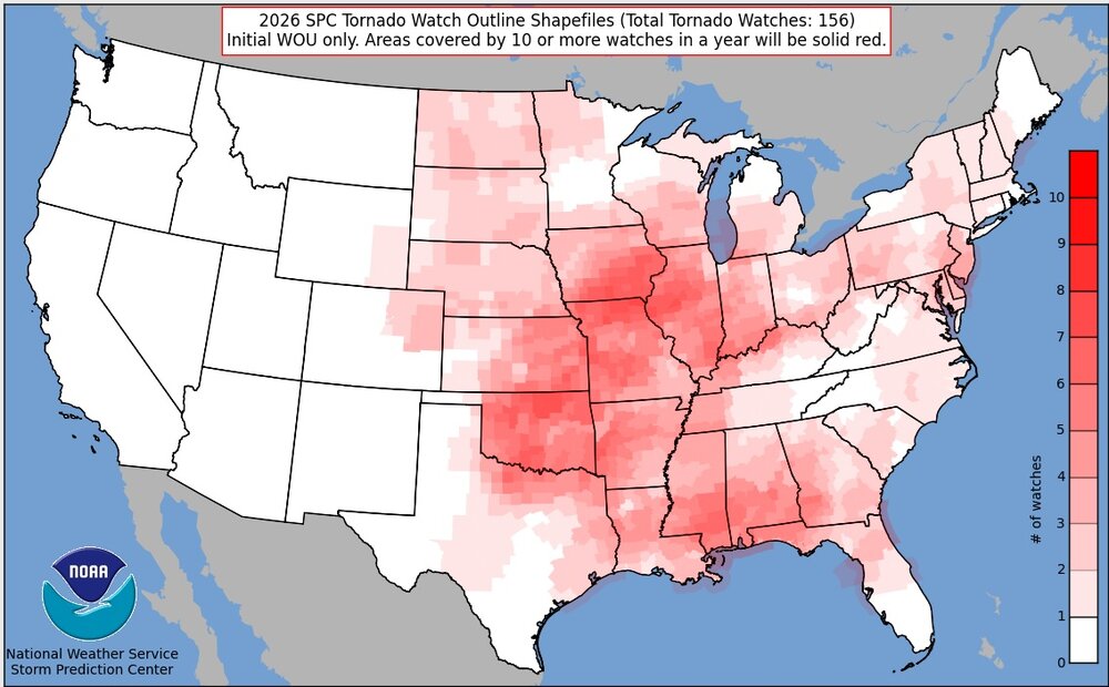
Kind of interesting that Illinois doesn't really stand out on the tornado watch summary map.
-
Sneaky shower complex caught even me off guard, looked at the radar and it was coming in from the West . I don't believe this was in the forecast I hope I get surprised by a few snow squalls doing the winter
- Today
-
This season is more conformation that the a long term regime shift occurred back in 2007. Thickness dramatically fell as the older sea ice melted. A June and July pattern like this season with deep low pressure north of Alaska before 2005-2007 would have resulted in a September minimum in the 6 to 8 million sq km range. But since the thickness was so low where the big Pacific side melt recently occurred, the area couldn’t hold the extent gains like it would have back in the colder climate era with thick multiyear ice more resistant to higher pressure and warmer recent conditions. https://www.nature.com/articles/s41586-022-05686-x Regime shift in Arctic Ocean sea ice thickness Manifestations of climate change are often shown as gradual changes in physical or biogeochemical properties1. Components of the climate system, however, can show stepwise shifts from one regime to another, as a nonlinear response of the system to a changing forcing2. Here we show that the Arctic sea ice regime shifted in 2007 from thicker and deformed to thinner and more uniform ice cover. Continuous sea ice monitoring in the Fram Strait over the last three decades revealed the shift. After the shift, the fraction of thick and deformed ice dropped by half and has not recovered to date. The timing of the shift was preceded by a two-step reduction in residence time of sea ice in the Arctic Basin, initiated first in 2005 and followed by 2007. We demonstrate that a simple model describing the stochastic process of dynamic sea ice thickening explains the observed ice thickness changes as a result of the reduced residence time. Our study highlights the long-lasting impact of climate change on the Arctic sea ice through reduced residence time and its connection to the coupled ocean–sea ice processes in the adjacent marginal seas and shelves of the Arctic Ocean The relationship between sea ice residence time in the Arctic Ocean and ice thickness distribution highlights the importance of coupled ocean–sea ice processes in the Alaskan and Siberian sectors of the Arctic (areas A and B in Fig. 3b). Several interrelated factors have become more prominent in the late twentieth century and have contributed to preconditioning the ocean–sea ice system before the stepwise changes in the ice formation areas: Arctic-wide rise of surface air temperature35, thinning of sea ice36, decrease of sea ice albedo37 concurrent with a reduction of multi-year sea ice38, increase of ocean heat flux through the Bering Strait39 and increase of the upper ocean heat content40. September sea ice concentration in the Siberian sector dropped below 40% in 2005 and the dramatic Arctic summer sea ice extent minimum occurred in 2007 (ref. 41). This series of events initiated intensive and widespread ice–albedo feedback in the Alaskan and Siberian sectors in the summer42,43, which resulted in a perennial increase of ocean heat content in areas of ice formation (Extended Data Fig. 1). After 2007, suppression of winter ice growth due to the accumulated ocean heat became conspicuous44 and the resultant thinner ice pack became more vulnerable to summer melt in the following year. Prolongation of the summer melt season promoted further ice–albedo feedback45 and has increased oceanic heat absorption in the summer7. Thus, summer ice extent and thickness in areas of ice formation has not recovered to the state before 2007 (Fig. 4c). In addition, continuing weakening of the cold halocline in the Siberian sector also influenced the upper ocean heat content46 and possibly slowed down ice growth offshore of the Laptev Sea in recent years17. Our analysis demonstrates the long-lasting impact of climate change on Arctic sea ice through reduced residence time, suggesting an irreversible response of Arctic sea ice thickness connected to an increase of ocean heat content in areas of ice formation. The large reduction of summer ice extent in the Alaskan and Siberian sectors in 2005 and 2007 triggered intensive ice–albedo feedback42,45 and initiated the perennial increase of ocean heat content in these areas44. This resulted in the stepwise reduction of residence time of sea ice in the Siberian sector of the Arctic, and hence a nonlinear response of the system. Before the shift, sea ice formed in and offshore of the Siberian shelves overwintered (spent about 15 months) in this area before entering the TPD (Extended Data Fig. 2), during which the ice thickened and increased its deformed fraction. After the shift, ice stayed in this area only about 6 months on average (Extended Data Fig. 2), resulting in recruitment of newly formed younger ice into the TPD and more sea ice formation during TPD transit to the Fram Strait26. The younger ice is thin, weakly linked and features ridges with more shallow keels; hence, it is more prone to wind forcing pushing the ice towards the Atlantic sector of the Arctic28,47. This process accelerated the TPD from 2007 onwards (Fig. 4d), while enhanced wind forcing after 2007 may also have contributed to the acceleration of the TPD (Extended Data Fig. 7). Because of the shorter residence time, the part of the ice that has thermodynamically grown is thinner17 (reduction of modal thickness in Fig. 1b) and the relative amount of the deformed fraction of ice has decreased (Figs. 1band 2). Impacts of this regime shift in Arctic sea ice on the pan-Arctic environment are extensive and require further investigation. Thinner and less deformed sea ice causes reduced momentum exchange between ice and ocean, contributing to reduced mixing in the upper ocean underneath areas that are fully covered with ice. This may affect entrainment of heat and nutrients from subsurface to surface ocean with a potential consequence on the biogeochemical cycles involving higher trophic levels. By contrast, however, sea ice retreat in marginal ice zones and continuing weakening of the cold halocline in the Atlantic sector allows for more turbulent mixing and winter convection in the upper ocean46. These counteracting effects can influence the regional contrasts of the ocean environment between fully ice-covered areas and marginal ice zones in the Arctic. In addition, habitat conditions of younger, level sea ice are different from those in older multi-year ice and might affect the sympagic (ice-associated) communities and their diversity48,49. Ridged sea ice supports higher biomass48 and represents safe havens for organisms to hide from predators50. The amount of ridges and deformed ice has also consequences for human activity. Thinner, more level ice is less challenging for ship navigation than in thicker, deformed ice and, along with less ice/shorter ice seasons in general, may allow for an increase in Arctic maritime traffic. Finally, interdisciplinary studies in the Atlantic sector of the Arctic and downstream of the Fram Strait outflow are needed to shed light on the consequences of the described sea ice regime shift and its impacts on physical and biogeochemical processes. Zack Labe @zacklabe.com · 3d It's time! Join me in tracking this year's #Arctic sea ice minimum! A new record is unlikely again this year. Sea ice melt substantially slows every September as solar energy decreases and temperatures drop in the far north. Follow along with the data at zacklabe.com/arctic-sea-i... ALT
-
http://cashbridgeconnect.com/# quickest payday loans online