All Activity
- Past hour
-

Feb 22nd/23rd "There's no way..." Obs Thread
ifindppl replied to Maestrobjwa's topic in Mid Atlantic
37.4 and steady rain in Olney. -

"Don’t do it" 2026 Blizzard obs, updates and pictures.
WinterWolf replied to Ginx snewx's topic in New England
Gonna be a good one bro…let’s do it. -
.thumb.jpg.6a4895b2a43f87359e4e7d04a6fa0d14.jpg)
Central PA Winter 25/26 Discussion and Obs
Yardstickgozinya replied to MAG5035's topic in Upstate New York/Pennsylvania
Good luck today fellows. Hopefully when I wake up your all out shoveling off your roofs. -

“Cory’s in NYC! Let’s HECS!” Feb. 22-24 Disco
SouthCoastMA replied to TheSnowman's topic in New England
NAM a few mb stronger, though a tick east early on as mentioned -

Is we back? February discussion thread
Baroclinic Zone replied to mahk_webstah's topic in New England

-
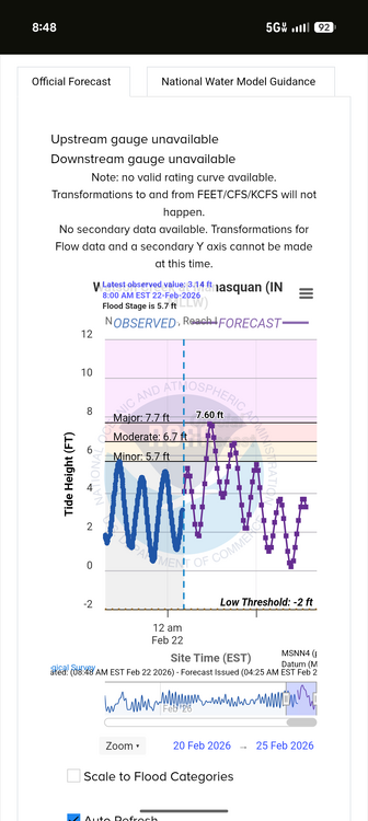
Tide predictions up a half foot since yesterday. Manasquan now touching major.
-
Temp has dropped a bit with the heavier rain but no snow flakes in sight despite my intense squints out the window
-
Wakefield for here. Seems optimistic but we will see. Quite windy now from the NE. Need to see it go NNE and North. Today Rain before 4pm, then rain, possibly mixed with snow. High near 44. North wind 13 to 16 mph, with gusts as high as 25 mph. Chance of precipitation is 100%. Little or no snow accumulation expected. Tonight Rain and snow, becoming all snow after 10pm. The snow could be heavy at times. Low around 32. Breezy, with a northwest wind 17 to 21 mph, with gusts as high as 34 mph. Chance of precipitation is 90%. New snow accumulation of 1 to 3 inches possible.
-

Feb 22nd/23rd "There's no way..." Obs Thread
mitchnick replied to Maestrobjwa's topic in Mid Atlantic
I would be too, but who knows if it will. -
Western parts of the area aren't far from of a 4-6 inch snowstorm if she were to wobble a bit further east, so it's really a nowcasting, watch the radar time. I am confident some areas will get 18+ and really jackpot, and it will be interesting to overlay actuals with the models when all is said and done.
-

Feb 22nd/23rd "There's no way..." Obs Thread
Eskimo Joe replied to Maestrobjwa's topic in Mid Atlantic
70/30 snow rain now. Temp down to 33 degrees! -

Feb 22nd/23rd "There's no way..." Obs Thread
Solution Man replied to Maestrobjwa's topic in Mid Atlantic
Just look outside now -
Here in Bensalem I’m hoping I’m far enough east to clip the edge of the extreme banding that sets up later today/tonight. Here is 12z NAM h7, can see it’s trending farther E After the NAM I’m turning off the models though so I don’t stress myself out lol
-
Not for those that understand climo, dynamics, and history. Writing has been on the wall for many days that this was not going to be a big double digit storm for anyone west of the bay. Aside from areas east of 97 or in isolated elevation favored areas, this was having the look of a 2-6” storm. It helps to not believe the pretty maps.
-
What a great mountain when the conditions are right! I’m happy to see they are doing well and pissed they aren’t gonna open tomorrow. .
-
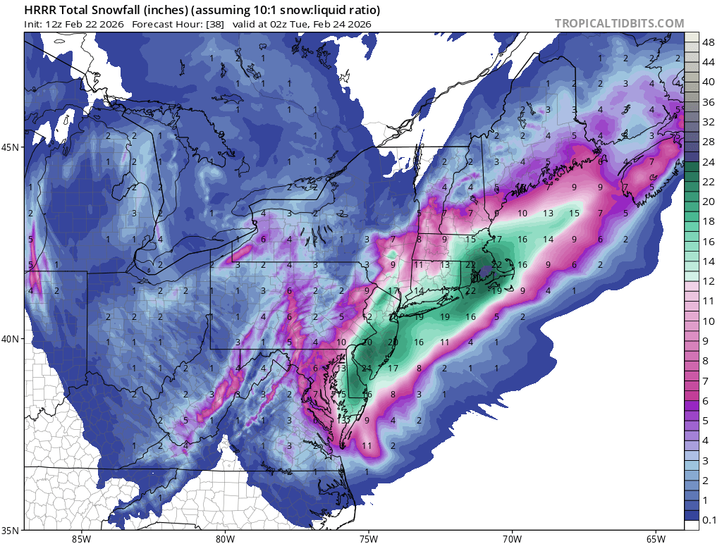
Tt looks the same? https://www.tropicaltidbits.com/analysis/models/?model=hrrr®ion=neus&pkg=asnow&runtime=2026022212&fh=1 I always use the 10:1 maps especially with these systems. You’re using the snow depth maps which again haven’t changed from 6z for those areas.
-
It was sick!
-
Yeah after you choose your photo click the “…” then choose options…the size choices will be there.
-

"Don’t do it" 2026 Blizzard obs, updates and pictures.
Sey-Mour Snow replied to Ginx snewx's topic in New England
Surprised by how steady the snow is, small flakes -
The reason it does tht is because the upper level low is capturing it and hooking it back twards the coastline. The is the so-called loop.
-
What fantastic timing for the boiler for or baseboard heating to blow. Going to be at least a week or two before the new boiler arrives. Oh what fun!
-

Central PA Winter 25/26 Discussion and Obs
pasnownut replied to MAG5035's topic in Upstate New York/Pennsylvania
Im in it as well. Starting to fill. Gonna start soon USA USA USA!! -

Feb 22nd/23rd "There's no way..." Obs Thread
davidjd1114 replied to Maestrobjwa's topic in Mid Atlantic
That I would be ok with/seems more likely to happen? . -
You can see the Great Lakes system interacting with the developing low near the OBX https://cyclonicwx.com/radar/us/ Once those two get together and party = obscene snow weather in the DMV then points north and east.


.thumb.png.991e09c19c25af7391ed569a205a5136.png)


.thumb.jpeg.f5c6ba9d911ec96b3b124f8606aee58e.jpeg)


