All Activity
- Past hour
-
AI models are shifting north with thermals. Folks in western and central NC should think about getting a generator.
-
Just for posterity.
-

Possible Record Breaking Cold + Snow 1/25 - 1/26
CPcantmeasuresnow replied to TriPol's topic in New York City Metro
The January 1996 blizzard dropped 21 inches on JFK airport with 1.1 qpf. This storm would have similar temperature profiles at least, don't know about the other dynamics involved. -

January 2026 regional war/obs/disco thread
wxsniss replied to Baroclinic Zone's topic in New England
Quick glance and thoughts, sorry if posted earlier: • GFS / AIGFS alone in terms of timing of stream interactions, too little too late for SNE... can't be certain it's wrong, but I favor this having impact on SNE, and potentially very big impact if we can get northern stream interaction sooner rather than a later infusion of trailing energy at exit • some similarities to Feb 15-18 2003 aka PD2 at H5... https://www.meteo.psu.edu/ewall/NARR/2003/us0217.php • interesting that AI-GFS vs. AI-EC very different from each other compared to their strong consensus for Jan 18 event • lost in the trenches of forecasting an upcoming event... this definitely feels like we're turning a corner in SNE compared to last 4 years -
True. Sleet might be underrated. Big FZRA storms I can do without, though.
-
MKE URGENT - WEATHER MESSAGE National Weather Service Milwaukee/Sullivan WI 1240 PM CST Tue Jan 20 2026 WIZ046-047-051-052-056>060-062>072-210245- /O.NEW.KMKX.EC.A.0001.260123T0600Z-260124T1800Z/ Marquette-Green Lake-Fond du Lac-Sheboygan-Sauk-Columbia-Dodge- Washington-Ozaukee-Iowa-Dane-Jefferson-Waukesha-Milwaukee- Lafayette-Green-Rock-Walworth-Racine-Kenosha- Including the cities of Endeavor, Germantown, Benton, Markesan, Oxford, Shullsburg, Muskego, Cedarburg, Oostburg, Portage, Jefferson, Belmont, Waupun, Reedsburg, Columbus, Watertown, Waukesha, Berlin, Fond Du Lac, Dodgeville, Fort Atkinson, Madison, Beaver Dam, Princeton, Montello, Grafton, Argyle, Whitewater, Mequon, Barneveld, Baraboo, Darlington, Brookfield, Sheboygan Falls, Janesville, Beloit, Lake Geneva, Plymouth, Mayville, Menomonee Falls, Elkhorn, West Bend, Delavan, Lake Wisconsin, East Troy, Prairie Du Sac, Racine, Kenosha, Howards Grove, New Berlin, Sauk City, Monroe, Westfield, Milwaukee, Mineral Point, Lodi, Neshkoro, Hartford, Blanchardville, and Brodhead 1240 PM CST Tue Jan 20 2026 ...EXTREME COLD WATCH IN EFFECT FROM LATE THURSDAY NIGHT THROUGH SATURDAY MORNING... * WHAT...Dangerously cold wind chills as low as 40 below possible. * WHERE...Portions of east central, south central, and southeast Wisconsin. * WHEN...From late Thursday night through Saturday morning. * IMPACTS...The dangerously cold wind chills as low as 40 below zero could cause frostbite on exposed skin in as little as 10 minutes. PRECAUTIONARY/PREPAREDNESS ACTIONS... Dress in layers including a hat, face mask, and gloves if you must go outside.
-
Are you allowed to share this? .
-
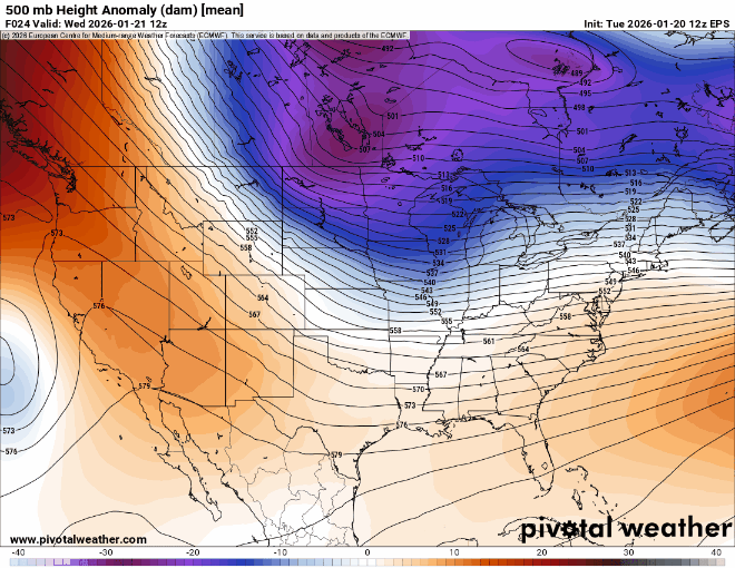
SREF looks north
-

Richmond Metro/Hampton Roads Area Discussion
Conway7305 replied to RIC Airport's topic in Mid Atlantic
Safe to say we are in a good spot at moment

-
North shift bay-bee
-
Looks like 0z runs tomorrow night.
-

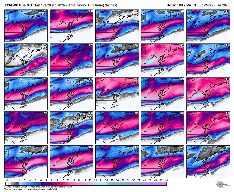
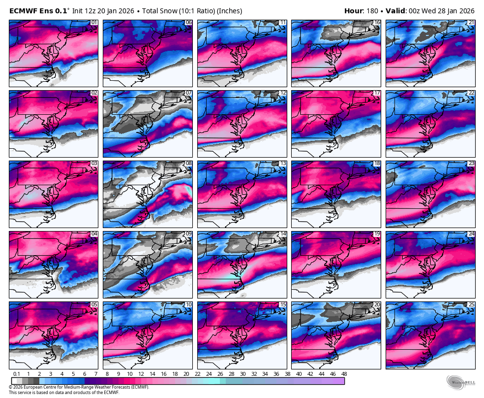
Possible Record Breaking Cold + Snow 1/25 - 1/26
donsutherland1 replied to TriPol's topic in New York City Metro
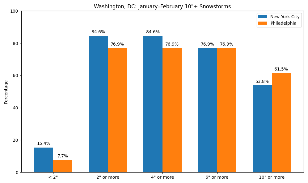
At present, it appears very likely that Washington, DC will see 6" or above snowfall during the January 24-26, 2026 snowstorm. Since 1950, below is the distribution of outcomes based on 6" or above and 10" or above January-February snowstorms in Washington, DC for New York City and Philadelphia. In theory, guidance with the higher-skill initialization (4dVAR)/better resolution (ECMWF, GGEM, and UKMET) should have a better handle at the current lead time. One can't fully dismiss the GFS, especially as there are ensemble members that support its solution. However, if one also weighs the historical outcomes while waiting for the guidance to reach higher skill levels in resolving the synoptic details (usually within 3 days of the event), it seems plausible that New York City and Philadelphia are possibly in line for at least a 3"-6" snowfall with upside potential if full phasing takes place and the storm tracks closer to the coast.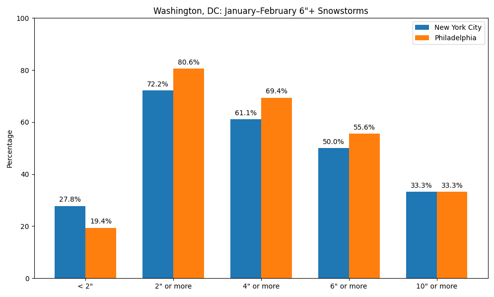
-
Anyone know when this will be integrated into the models @high risk @MillvilleWx @WxUSAF
-
-
@WxWatcher007id sell my soul to you for minimum 2 years if this verified. Let the Reaper come back!
-
That is my greatest memory of Bob Ryan. I used to “argue” with him on tv and loved watching him increase the forecast.
-

1/23/26-1/25/26 Winter Storm Thread
Holston_River_Rambler replied to AMZ8990's topic in Tennessee Valley
Looks like the para CMC jumped about 200 miles south with its snow line since 0z. 40 north now instead of central KY -
Well, evidently the Scooters groundhog has some kind of Puxatony Phil powers. Didn't seem overly scared of his shadow, but maybe that is what happens when good folks slip you a cake bite now and then - got to stay visible.
-

Possible Record Breaking Cold + Snow 1/25 - 1/26
Krs4Lfe replied to TriPol's topic in New York City Metro
If this pans out as forecast, its a winter saver for DC-Philly, which has been hurting in snow department this year. DC had average snow in 2019, 2024, and 2025. Philly had average snow in 2021 but baltimore has been snowholed since 2018. Baltimore has missed out on almost every big snow over past 10 years. Overall, entire I-95 corridor has been hurt by the 2020s, lowest snowfall average of any recorded decade. Boston can always get the late blooming blizzard, but wow has I-95 been lacking -

Central PA Winter 25/26 Discussion and Obs
canderson replied to MAG5035's topic in Upstate New York/Pennsylvania
The perfect storm amount imo. Not too much to absolutely destroy a week, but enough to kill a a day or two. Fluffy snow makes it even better since it’s easier to clear! FAIW Broadway show runners are already messaging about potential snow impacts. -
6hrs snowfall off latest Sref. Pretty far north. https://www.pivotalweather.com/model.php?m=srefens&p=sn10_006h-mean-imp&rh=2026012015&fh=87&r=conus&dpdt=&mc=&pwplus=1
-

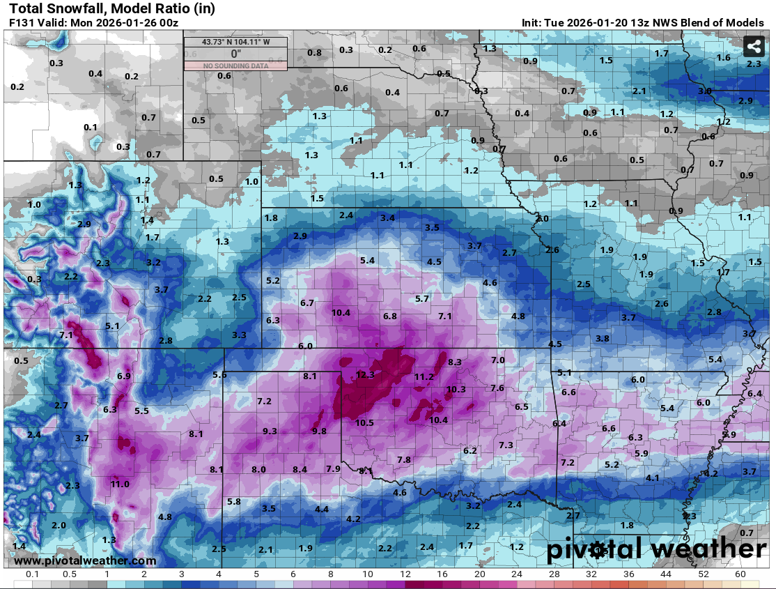
MO/KS/AR/OK 2025-2026 Winter Discussion
RocketWX replied to stormdragonwx's topic in Central/Western States
Here is the most recent run of NWS Blend of Models through Sunday evening. I haven't done a ton of research on it, but essentially it combines multiple numerical weather models and post processed data in hopes of giving an accurate and reliable starting point for NWS forecasts. I will say this most recent run is the most bullish with amounts across the board so far. Previous runs had ICT in the 3-5" range. This is probably due to a few factors. Models becoming more aligned as we go (confidence) and/or trends in the models. I'd still expect some fluctuations as we progress through the week, but I'd expect them to become smaller by the day. I'll be curious how this does as I don't have much history with it.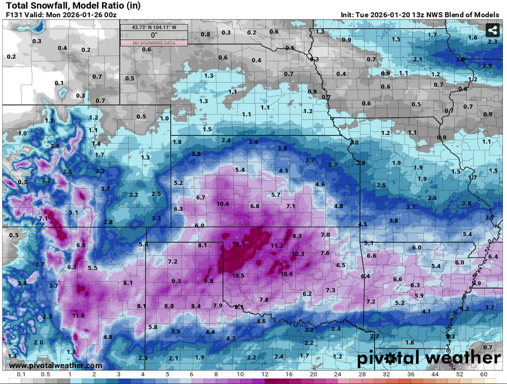
-

Possible Record Breaking Cold + Snow 1/25 - 1/26
eduggs replied to TriPol's topic in New York City Metro
On the EPS individuals I count 13 misses and 11 big hits out of 50. The rest are light to significant hits. ~25% miss rate is still pretty high. Still plenty of variability. -
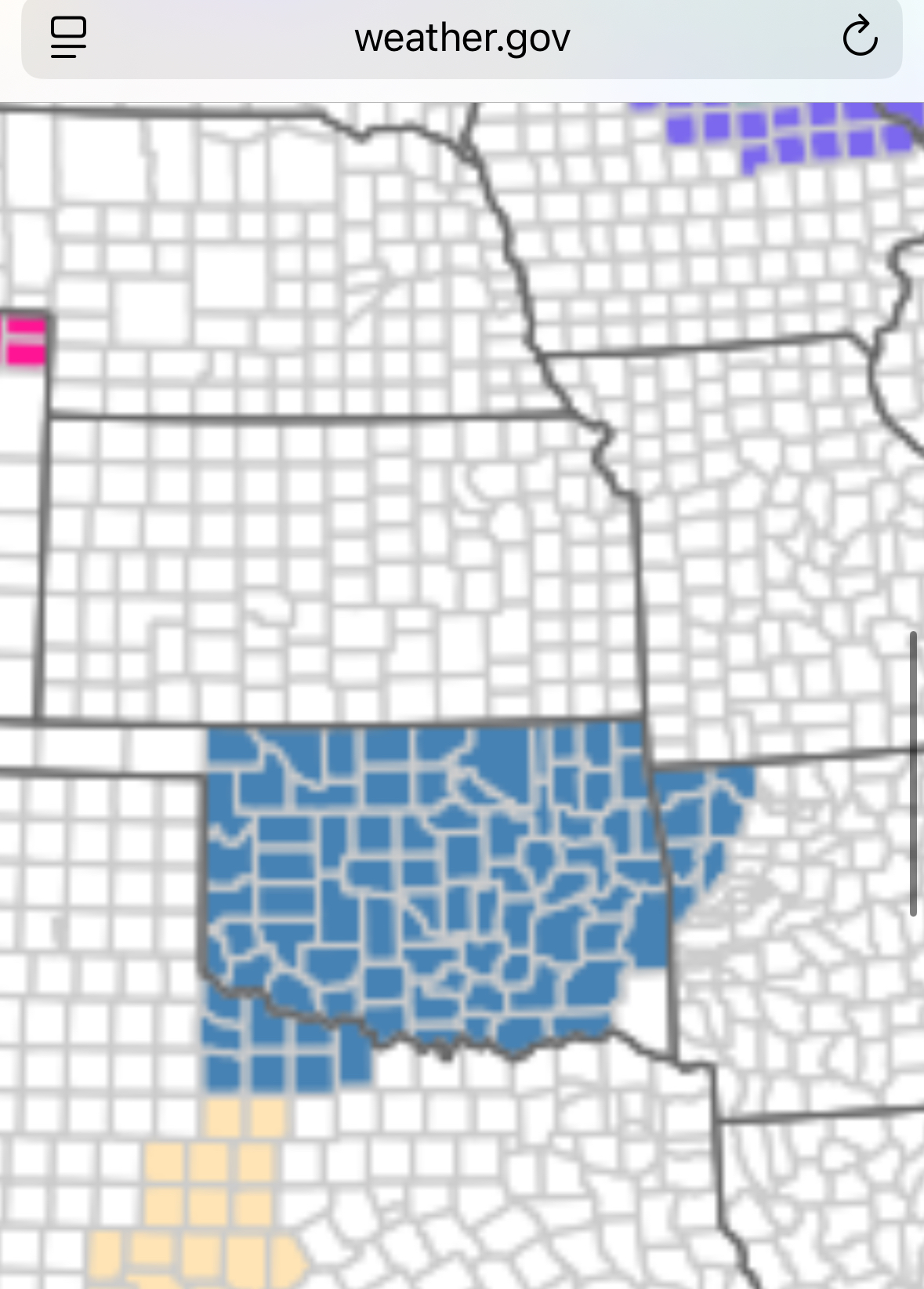
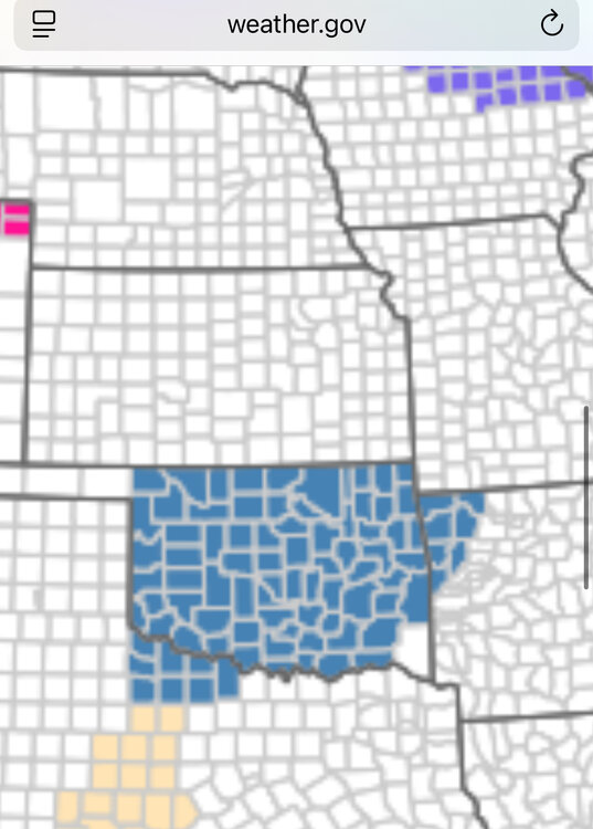
The first watches for the storm have gone up out west.
-
It’s beautiful