All Activity
- Past hour
-
The snowfall departures have actually been similar from DC to Boston last 7 years. I never mentioned any point of no return. Just that a warmer storm track and winter background temperatures will mean less snow than we used to get. Even in this much warmer climate we have still managed in NYC to avoid a shutout season. But places like Philly and DC have come close in recent years.
-
remember when october 2007 felt shocking
-

2025-2026 ENSO
40/70 Benchmark replied to 40/70 Benchmark's topic in Weather Forecasting and Discussion
We agree on that...ceiling is still higher than that for Boston. -

Occasional Thoughts on Climate Change
TheClimateChanger replied to donsutherland1's topic in Climate Change
And it's kind of surprising too, when a lot of empirical data supports warming in that era. This blog suggests a systemic early warming bias in the instrumental temperature records that predate the adoption of the Stevenson Screen, and questionable SST data... although I'm not sure how that would impact proxy-based reconstructions. It looks to me like a lot of proxy data (e.g., the above) would support warming, but I'm not sure if empirical data like this enters into the proxies since such data does not exist for earlier years. Early global warming -
.thumb.png.4150b06c63a21f61052e47a612bf1818.png)
Spooky Season (October Disco Thread)
HIPPYVALLEY replied to Prismshine Productions's topic in New England
Yeah, it’s going to suck if we lose Sunday and Monday to rain. -
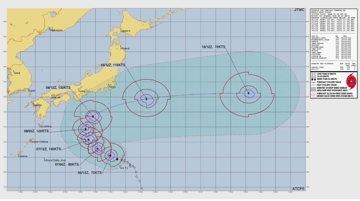
 Japan really lucking out with Typhoon Halong’s forecast track:
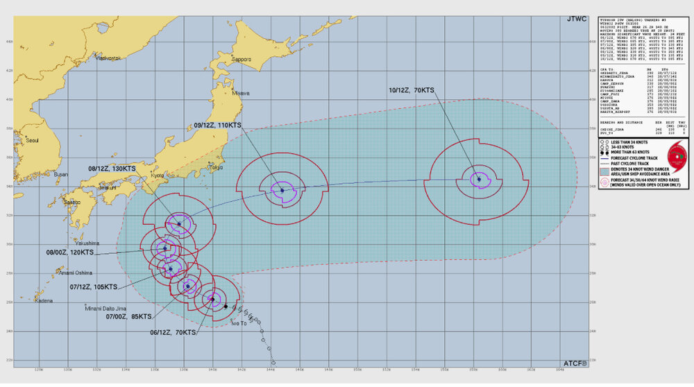
-

Spooky Season (October Disco Thread)
Damage In Tolland replied to Prismshine Productions's topic in New England
Do you still work night shift at grocery ? -
Occasional Thoughts on Climate Change
TheClimateChanger replied to donsutherland1's topic in Climate Change
I think the weirdest thing is how it was there was a general consensus that the late 19th century and turn of the 20th century was unusually warm among period scientists, but a lot of bogus "reconstructions" today try to tell us it was the coldest since the early Holocene. See, e.g., below, that period is shown as nearly the coldest in the past 1,000 years, surpassed only by a cooler interval in the 15th century. Makes a big difference with how the present looks compared to the past. If there was already say 0.2 or 0.3C warming by 1900, then we're even further off the charts then commonly supposed. It makes VERY little sense to say these very smart people were investigating the cause of the observed warming trend, when, in fact, it was unusually cold. But if you buy the reconstruction below, that's exactly the implication to be drawn. -

Spooky Season (October Disco Thread)
ineedsnow replied to Prismshine Productions's topic in New England
I'm working so wont make working so bad for me -
You'd need a very cold air mass to get locked in to our n/nw and those kinds of air masses have been rare in recent years. WX/PT
-
The polar jet/cold air source is way north in Canada and this low would entirely be a product of the subtropical jet. It would be cold rain or a mix like what we had in 97-98 or 23-24. But that’s if it even develops.
-

Spooky Season (October Disco Thread)
Typhoon Tip replied to Prismshine Productions's topic in New England
One could drive from Caribou ME ot Pittsburgh PA and never see a cloud today -
I also find a reverse correlation in Oct but it’s for the first half and for temps
-
Obviously I meant if this was occurring in January or thereabouts.
-
Last winter was torture here-nothing worse than freezing with some cirrus while watching the Deep South get slammed, then when a storm can finally make it here it turns into a SWFE (we had one decent 4-6” SWFE in Feb but that’s the exception around NYC) or cutter. I’d rather have the 22-23 scenario where like you said it was clear way out in time our window is slammed shut.
-
Good luck with the move. Hopefully, you will get some good snowfall this coming winter.
-

E PA/NJ/DE Autumn 2025 Obs/Discussion
Mikeymac5306 replied to PhiEaglesfan712's topic in Philadelphia Region
October typically has that long duration slow moving rain system where it is windy, and miserable for a few days. Not necessarily a tropical system, more of a noreaster hybrid... That being said. The 6z runs are showing it for late next weekend. -
Spooky Season (October Disco Thread)
Typhoon Tip replied to Prismshine Productions's topic in New England
Put some thoughts down re that coastal system the Euro/GGEM/GFS are hard selling over in the tropical thread. Little suspect that it's being over-amplified at this range. we'll see - -

Central PA Fall Discussions and Obs
Jns2183 replied to ChescoWx's topic in Upstate New York/Pennsylvania
It's not a big game so of course it will happen Sent from my SM-G970U1 using Tapatalk -
This will be my last winter for a chance for a 40" snowfall in the NYC metro area. I'll be moving to Morristown Tennessee in late Spring...
-
The EF-5 drought has been broken. .
-
You described verbatim what will happen. I do like a cold winter but it is frustrating to have a january 25 type scenario where you know it's cold enough to snow but you just keep getting unlucky. At least if its a january 23 type thing you know there's no chance anyway.
-
Wow! Well the streak ends I guess
- Today
-
@weatherwiz
-
The Enderlin tornado in ND was upgraded to an EF5. First one since Moore 2013