All Activity
- Past hour
-

Central PA Summer 2026 Discussion/Obs Thread
mahantango#1 replied to Voyager's topic in Upstate New York/Pennsylvania
Monday COULD be a severe weather day, according to NWS State College afternoon discussion. We will know more tomorrow. -
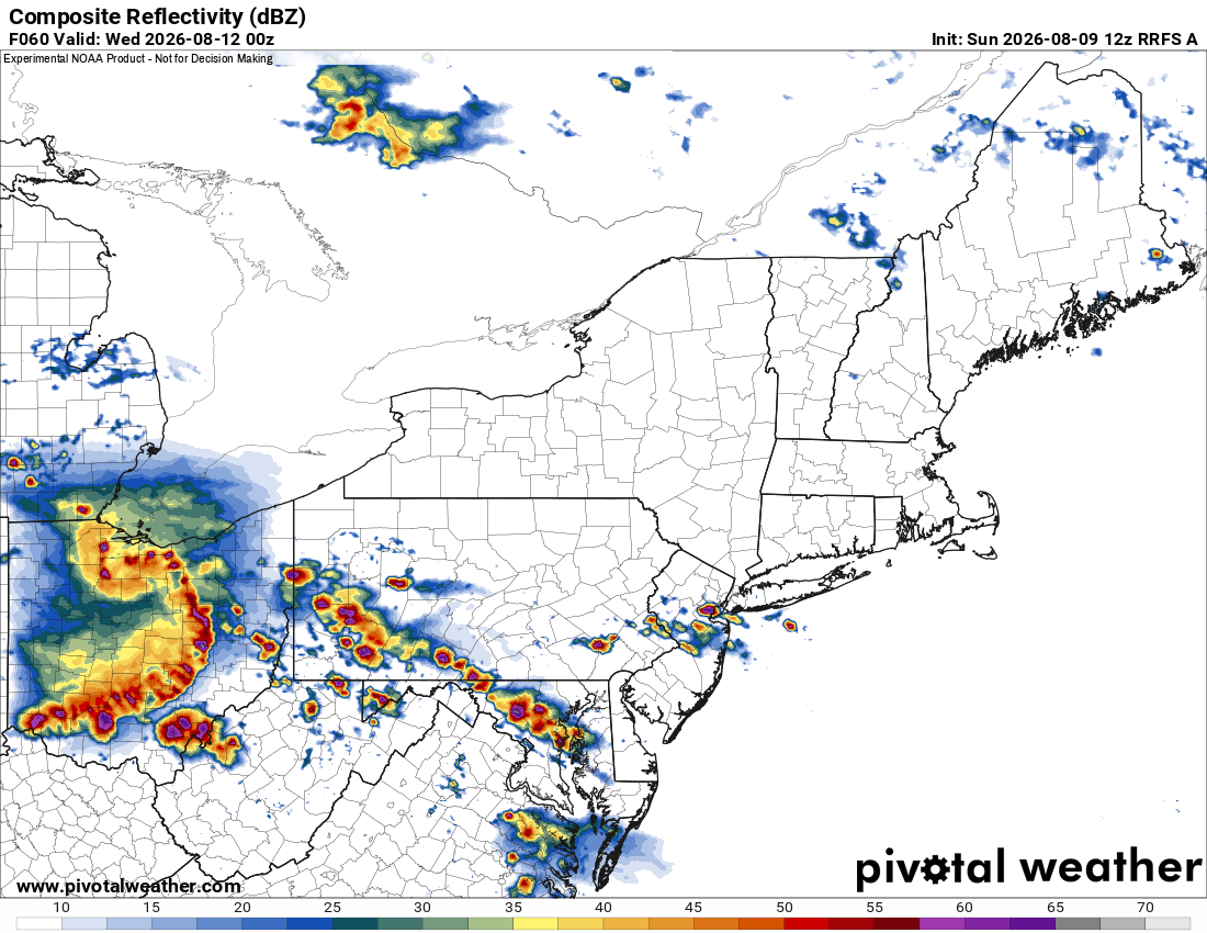
Looks active Mon-Wed here. HRRR/RRFS suggesting multiple waves of tstms and derecho potential. Seems like there will be one in the OH Valley Tue, and the 12z RRFS is hitting that very hard. Attached is the RRFS valid 00z Wed. Wow. And you have storms firing on the front WNW to ESE right into the DMV area, like a large warm advection wing seen on many derechoes. HRRR through 48 hr seems to have the same idea. Pattern is favorable for derechoes/long-lived bow echoes. The issue typically is though, can an OH Valley derecho make it over the Appalachians intact? It's hard to do. The June 2012 did, but that was the exception. SPC also has the region outlooked for svr DY4 (Wed).
-
In what world does it make any sense for Gunner to bat lead off. At this point he is what he is which is a below average hitter. He should be in the bottom half of the order but Albernaz is void of any balls.
-
Augdewst 2026: Summer's Last Stand
78Blizzard replied to Prismshine Productions's topic in New England
Another day failing to make it to 90 here. That makes it 1 out of 5 days so far that the GFS has us 90+. Today we were supposed to hit 94 here. The high was 88. Currently 86. We hit 90 for about 1 hour on Friday. Just your typical summer period with high humidity. -
2026 Severe Wx - General Thread
CheeselandSkies replied to largetornado's topic in Lakes/Ohio Valley
Looks like a swing and a miss for a peak heating supercell threat today. However 5 years ago OTD was a different story. I remember @Chicago Storm being super gung ho about this setup on here which was one of the reasons I went for it despite SPC only having a 2% (later upgrade to 5%). He nailed the longer-lived/more photogenic Sycamore-Virgil tornadoes. I saw the storm I was on go HP on the next cycle and started for home, thinking it would have worked over the atmosphere. However I still consider the Kirkland EF1 my first "official" tornado since it's the first one I was actually able to stop, tripod and watch for a few minutes instead of frantically driving to get either closer to (such as the Esmond EF0 at the beginning of the video) or out of the way of it. -
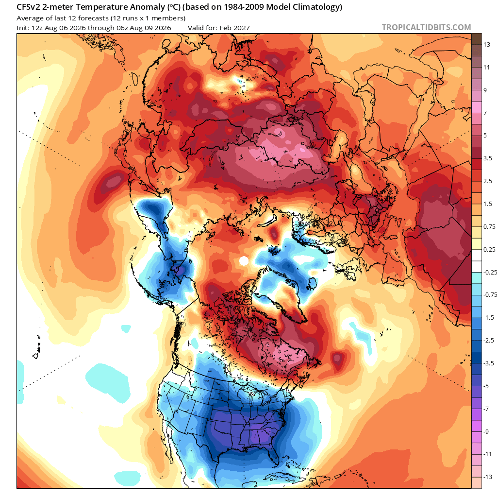
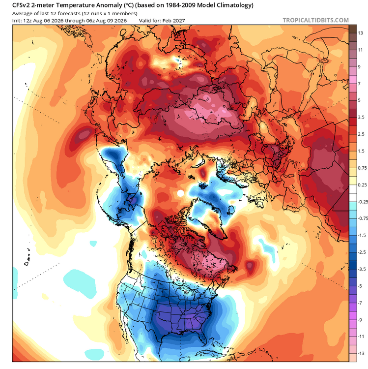
Surface temps for Feb-
-

Augdewst 2026: Summer's Last Stand
WxWatcher007 replied to Prismshine Productions's topic in New England
Day four of 90+. August heat wave of yore. -
CFS continues to advertise a favorable look at h5 and at the surface for late winter. This model is generally not known to be consistent run to run(lol shocker) but it has been pretty steadfast with this look for many runs. Giga? March looks just as good and Jan is pretty acceptable.
-
-

Augdewst 2026: Summer's Last Stand
jbenedet replied to Prismshine Productions's topic in New England
not typical by climate standards but I do expect this now. Another 90+ degree day here -

Augdewst 2026: Summer's Last Stand
CoastalWx replied to Prismshine Productions's topic in New England
I care more about that since winter is too long for 45 and mud for months. -
March 2026 in the American west seemed absurd too until it happened.
-

Augdewst 2026: Summer's Last Stand
dendrite replied to Prismshine Productions's topic in New England
Definitely some smoke/haze aloft this afternoon. -
Augdewst 2026: Summer's Last Stand
dendrite replied to Prismshine Productions's topic in New England
I picture him screaming this when he’s at 10” on the season entering March. -

Augdewst 2026: Summer's Last Stand
vortex95 replied to Prismshine Productions's topic in New England
- Today
-
The squall line looks good over the Lake. Starting to darken up here. Warnings already up just to my north for 60 mph winds. I think those 60 mph gusts will be isolated but I’m ready for a healthy storm.
-
 Cialis over the counter Tadaliko - Buy Tadalafil 5mg
 -

Central PA Summer 2026 Discussion/Obs Thread
canderson replied to Voyager's topic in Upstate New York/Pennsylvania
It’s hot as f out. -
Cialis 20mg price Buy Tadalafil 20mg - Tadaliko
-

Augdewst 2026: Summer's Last Stand
SouthCoastMA replied to Prismshine Productions's topic in New England
85/75, a quintessential Cape beach day that said, I'm in Portsmouth NH now and it's about 90/65 -
some rain and small hail in the Chicago area. Possible 1" hail by Aurora.
-
http://sildoliko.com/# viagra without prescription
-
Should see another 1-2 inches here, our new standard summer rainfall
-
Maybe one of these years Minneapolis will get mcs after mcs while the rest of the sub droughts. At least it’s been a good year for ORD diversions. Love all the different heavies we’ve been getting this summer.