All Activity
- Past hour
-
I just got back from Sarasota a couple days ago from a family wedding and mini vacation and man this is a tough adjustment. 80 nearly everyday with a gentle breeze in the evening and walking around in shorts everywhere is hard to beat. I did get a bit of a burn on my upper back and shoulders but it’s totally worth it just having that nice change of pace for a while!
-

January 25-26th, 2026 Final Storm Totals
Baroclinic Zone replied to The 4 Seasons's topic in New England
Ahhh, reminiscing. 1 of 2 20”+ storms this year. -
by the way, this large hail storm was right at Springfield MO
-
Tomorrow will see temperatures reach the lower 60s. Another shot of rain will arrive. A general 0.50"-1.00" rainfall appears likely tomorrow into Thursday. Following the rainfall, temperatures will top out in the lower 60s through Saturday. May will likely open with cooler than normal conditions. Sunday could be especially cool with highs only in the upper 50s. The ENSO Region 1+2 anomaly was +1.5°C and the Region 3.4 anomaly was +0.7°C for the week centered around April 22. For the past six weeks, the ENSO Region 1+2 anomaly has averaged +1.47°C and the ENSO Region 3.4 anomaly has averaged +0.27°C. El Niño conditions will likely develop during late spring or early summer. The SOI was -15.07 today. The preliminary Arctic Oscillation (AO) was +0.394 today. Based on sensitivity analysis applied to the latest guidance, there is an implied near 100% probability that New York City will have a warmer than normal April (1991-2020 normal). April will likely finish with a mean temperature near 55.2° (1.5° above normal). Supplemental Information: The projected mean would be 2.2° above the 1981-2010 normal monthly value.
-
18z HRRR is insistent on //some// rain for everyone, but it really tries to run a few decent thunderstorms north of I-66 that drop localized 1" amounts.
-
Drove the pike to Lee today, still full stick season at 1,700 feet in Becket
-
Let’s make a plan together to “MYLGA”
-

The "is it ever going to rain again?" discussion.
JenkinsJinkies replied to JenkinsJinkies's topic in Mid Atlantic
-
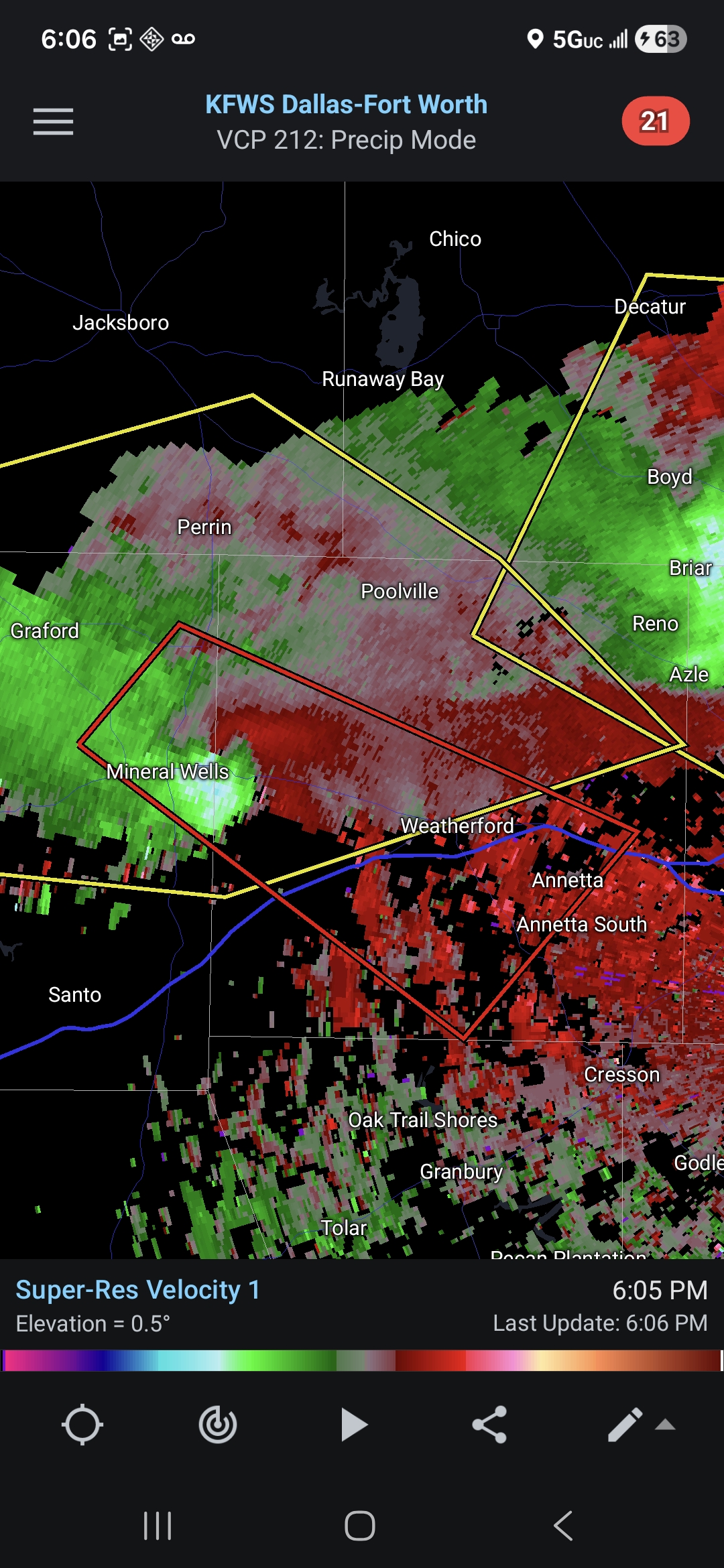
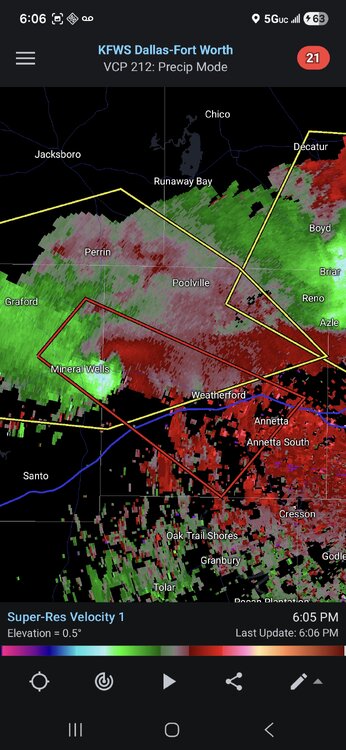
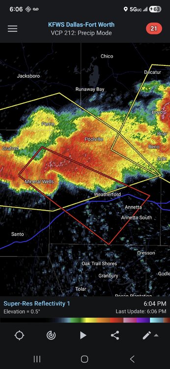
Decent couplet on the cell near Mineral Wells TX. Solid radar presentation as well.
-
dangerous supercells near Fort Worth
- Today
-
Peak wind gust of 67MPH at ARR yesterday afternoon with the wake low, just down the road from home. Had isolated to scattered branches down around town. ORD had a peak wind gust of 54MPH.
-
I won't trigger your OCD with a picture of my "lawn". It is, unfortunately, mostly weeds.
-
Looks frieken fabulous!
-

E PA/NJ/DE Spring 2026 Obs/Discussion
RedSky replied to PhiEaglesfan712's topic in Philadelphia Region
It was a record late freeze in many areas -

E PA/NJ/DE Spring 2026 Obs/Discussion
Birds~69 replied to PhiEaglesfan712's topic in Philadelphia Region
Isn't this around normal (last freeze) around these parts? What makes this year especially bad? AI Overview The average last spring freeze (32°F) in Philadelphia usually occurs between late March and mid-April, with central city areas often seeing their last frost around April 4th–5th and suburban or outlying areas frequently experiencing frost as late as April 15th–20th. A safe, conservative date to avoid damage to sensitive plants is often considered mid-May. The Old Farmer’s Almanac +4 Average Last Frost Dates: Central Philadelphia/Franklin Institute: ~April 4-5 Suburban/Higher Elevation: ~April 15-20 Risk Period: A 30% chance of frost remains up until April 25 in some areas. -

Central PA Spring 2026 Discussion/Obs Thread
canderson replied to Voyager's topic in Upstate New York/Pennsylvania
Ugh. Last I heard was they were think a 30-40% crop reduction. Very sad. -

Spring 2026 Pattern Discussion Thread
Carvers Gap replied to Carvers Gap's topic in Tennessee Valley
It rained like crazy here overnight. Very thankful. I do think we are heading towards a pattern w/ more rain, and much cooler weather. I would not be shocked to see snow at higher elevations(above 5000') during early May if things work out correctly. AT hikers need to pay attention. Big weather changes under way as we speak. I am not saying the drought gets busted(those often take months to eradicate), but we should get some relief. -
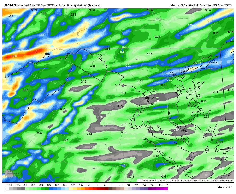
WB 18Z 3K NAM

-
Since you noted the errors first (a triple play), I'm responding your way. Average: 88.4" 2025-26: 86.8" Deficit: 1.6"
-
Brad P mentioned the possibility of very isolated strong/severe storms tomorrow. Obviously dont care for damage or anything, but im honestly craving a good evening thunderstorm.
-
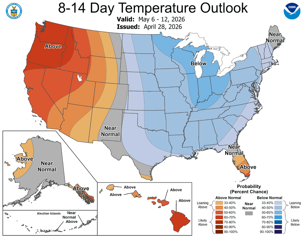
April is just about in the books, so we turn our attention to May flowers and the prospects of thunderstorms. CPC says cool and wet may be in order first.
-

Texas 2026 Discussion/Observations
Stx_Thunder replied to Stx_Thunder's topic in Central/Western States
Primary threat today around DFW still looks to be svr/large hail, once again. Significant Hail Index Parameter on special 19Z UA obs this afternoon is even higher than it was on Saturday evening's 0Z UA obs that was 3.4 At 4.0 this afternoon. Definitely high for that hail parameter, no doubt. I have not seen it go that high anywhere before in the state. As far as I can remember. -
Oak buds are starting to swell here. Things will probably slow down through the weekend. There's still a couple of freeze chances here Sun-Mon.
-
Take them apples-
-
Interesting. Now the Ravens have a third string QB. Why does he look like he is 35?