All Activity
- Past hour
-

2025-2026 ENSO
michsnowfreak replied to 40/70 Benchmark's topic in Weather Forecasting and Discussion
We are not in a completely different climate than we were in 2010. -
Cool and breezy. Another Fall like day to end May.
-
pushing 1.4" here and coming down at a good clip atm. nearing 9" for the month
-
Storms beginning to fire up near Hagerstown and North of State College. All moving SE .
-
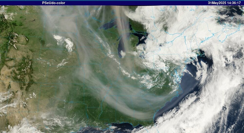
Still nasty smoke plume rotating southeast out of Canada. For the most part it is rotating under us today around base of trof / upper level low. As that lifts out we will likely see some affects from it tomorrow and Monday but bulk of it will be directed south and then east so mainly to our south.
-
Sure is. What a captivating image of the present storm system departing and the Manitoba smoke all interacting.
-
Getting a gusty shower with the temp falling to 60°. Doesn’t feel like June is a day away. 0.90” from yesterday which pushed me above 9.00” for the month.
-
https://www.weather.gov/wrh/TextProduct?product=pnsphi Latest rainfall numbers from latest PNS out of PHI.
-
My brother in Sussex County also said there’s localized flooding near Franklin.
-
It’s windy. 35 mph stuff
-
That tight little vortex spinning southward in SD is interesting
-
Parts if Orange County, NY experiencing flooding from upwards of 5 plus inches of rain.
-
Great news! I'm sure everyone enjoyed the weather.
-
wow it sounds like a big and heavy branch !!
-
That November snowstorm dropped a branch on my car that dented the roof and broke off my driver's side door mirror. Somehow by some miracle it didn't break any glass.
-

2025 hurricane season forecast contest -- enter by June 1st
GaWx replied to Roger Smith's topic in Tropical Headquarters
14/9/3 ACE 139 -

E PA/NJ/DE Spring 2025 Obs/Discussion
LVblizzard replied to PhiEaglesfan712's topic in Philadelphia Region
Big CME headed towards Earth with a possible G4 solar storm. If this were to put on an aurora show it would be tomorrow night when skies are clear. Fingers crossed! - Today
-
and Thursday and Friday too!
-
We also had this kind of situation here on November 7, 2012 in the snowstorm after Sandy (the first snowstorm TWC ever named: *Athena*-- great name!) 8-10 inches of snow and hazardous driving conditions with tree branches down everywhere. 14 inches south of us in Freehold, NJ. A very different winter from 2002-03 of course.
-
You mean 2002. That wraparound was amazing. I had about 8 inches but like 2 miles east were reports of almost 10 inches. I was driving a rear wheel drive stick shift car with performance tires not equipped for winter conditions. That evening was a crash course in winter driving lol. Car actually got stuck in the parking spot that I somehow managed to get it into.
-
Lets roast Tuesday and Wednesday. Bring it on!
-
A few normal days with warm temperatures then back down to low 80’s & chances of rain. Sat outside under our lights on the porch last night. No skitters or bugs. Quite cool & loved it. Have also been sitting on our screen porch a lot. These temps are fantastic & everything is so green! Winning summer so far!
-
If they're tent caterpillars you'll see webs in the v of trees.
-
Upton’s AFD for today, NEAR TERM /UNTIL 6 PM THIS EVENING/... Winds have been increased with this update to account for gusts that have occurred higher than expected. Moderate to heavy rainfall is beginning to taper with the low moving into the Lower Hudson Valley and SW CT. A Flood Watch remains in effect for the Lower Hudson Valley through 11 am. This area has racked up 1-3" inches of rain with many of the higher amounts in Orange county. Some wrap-around precipitation will move through mid to late morning through much of the area as the low exits north and east. As we get into late morning and early afternoon, the low will continue to exit northeast of the area. This brings in drier air & cuts off most of the more intense precip. Spotty to isolated showers may still occur into the early afternoon. Another chance for brief downpours with showers and thunderstorms may occur with a frontal passage behind the departing low late this afternoon into early tonight. Instability is marginal, so only a few rumbles of thunder are expected. Flood impacts will be minimal given the quicker progression of these showers with the front and given coverage will be less compared to this morning. Ahead of and with the front, a LLJ with move through west to east, which could lead to a spike in winds, leading to gusty conditions.
-
The 500mb low closed off in the right spot. The front end was ruined because the storm hugged the coast, but the closed off low kicked the low east and wrapped moisture around to the west to create the backlash heavy snow band.


